


The Kanderfirn is an icefield at the head of the Gastern Valley, between the Blümlisalp range on its northern side and the ice dome of the Petersgrat on its southern side. It feeds the Kander River, and on hot summer days contributes to the Kander's notably strong and cold flow through Kandersteg village.
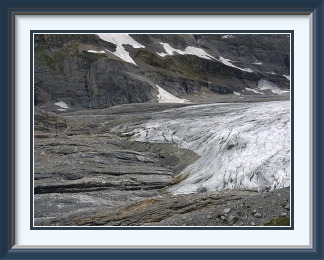 The Kanderfirn is a large, placid glacier lying between the Blümlisalp
Range to the north and the entirely snow-covered Petersgrat to the south.
It was a bold move to choose it as the first walk of the season, since it
could only be approached by walking the entire length of the strikingly
beautiful and very long valley called the Gasterntal, a distance of not much less than
fifteen Km. each way, but July 2014 had so far been extremely wet, and this
was a way to test conditions before venturing onto more exposed tops.
The Kanderfirn is a large, placid glacier lying between the Blümlisalp
Range to the north and the entirely snow-covered Petersgrat to the south.
It was a bold move to choose it as the first walk of the season, since it
could only be approached by walking the entire length of the strikingly
beautiful and very long valley called the Gasterntal, a distance of not much less than
fifteen Km. each way, but July 2014 had so far been extremely wet, and this
was a way to test conditions before venturing onto more exposed tops.
There is a one-way-at-a-time toll road to the hamlet of Selden, more than half the way up the valley, but driving it would miss the sensational scenery of the lower Gasterntal, the most impressive walled valley in the whole of the Alps. Also, the Congenial Swiss Lady was coming along for the trip, and would not want to see the Gasterntal through the window of a car.
The walk begins up the narrow road into the gorge through which the Gasterntal drains, at times hewn from the vertical rock. Beyond the gorge, the surprisingly level floor of the valley stretches away to the east, hemmed in by the precipitous walls of peaks like the Balmhorn and the Doldenhorn. Here there is a mixture of alpine pastures and light forest; none of the trees are very old, however, probably because avalanches too frequently obliterate them. At a bend near Selden, the valley narrows and we began to see efforts to repair the damage caused by a very wet month. Only fragments remained of the path I remembered from the last visit six years earlier. Fortunately there was another track further away from the water. Soon the Doldenhorn's SE face presented an imposing line of pinnacles far above. A thousand-ton boulder had somehow made it down from the heights unscathed, and some enterprising people had affixed a climbing rope to it, just visible on the left, and installed a bench on top.
Not much later, the track finally ended at the Alpetli viewpoint. A solitary cairn with "summit" book and half-baked cross marked the spot. From this point, a route continued up the Kanderfirn to the Mutthorn Hut on the crest of the ice at nearly 3000 metres, not something for walkers. Here at last we had a commanding view over the Kanderfirn, hidden as we climbed by a band of cliffs over which it once flowed. The Blümlisalp range behind had a fair amount of fresh snow above its hanging glaciers, evidence of July's poor weather; these faces would normally have been bare by this time of year. As we munched our sandwiches, we could also enjoy the view of the upper Gasterntal, with our path visible as it snaked up from the river to the old moraine it had used to gain height quickly.

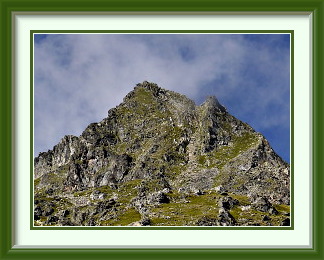
The Jolitaler Schwarzhorn is a mountain in the Bernese Alps between two two side valleys of the Rhône valley near the village of Raron, the Jolital and the Bietschtal. It is the southernmost point on a ridge which gains in height towards the north and the high peaks along the Lötschental.
 A terrible July continued; thunderstorms wrought havoc in the Emmental,
and the Emme River through Burgdorf was a chocolate-coloured torrent half
the time. Days of rain or just thick cloud alternated. I used one of the
latter kind to go up the Moléson in the western Prealps, but it was
photographically useless. It was now the last day of the month; while the drizzle
was fading away early in the morning, conditions north of the Alps were still
grey. Not the sort of weather where a walk was the first thing to come to
mind, but I wanted to squeeze one more in before the month ended.
A terrible July continued; thunderstorms wrought havoc in the Emmental,
and the Emme River through Burgdorf was a chocolate-coloured torrent half
the time. Days of rain or just thick cloud alternated. I used one of the
latter kind to go up the Moléson in the western Prealps, but it was
photographically useless. It was now the last day of the month; while the drizzle
was fading away early in the morning, conditions north of the Alps were still
grey. Not the sort of weather where a walk was the first thing to come to
mind, but I wanted to squeeze one more in before the month ended.
With hope springing eternal, I threw my stuff in the car and set off for Kandersteg. Not a chance... gloom hid everything above the valley floor, and the raging Kander River was barely contained within its banks. All that was left was to drive onto the tunnel train and see what things were like on the other side of the Bernese Oberland. They were better; the road was dry and clouds of a less threatening sort clothed the slopes. A walk would be safe, though the views might be limited.
I wasn't just heading blindly into the Valais; my SAC guide1 listed a peak in the area that looked practical even in less than ideal conditions. The Schwarzhorn overlooked the Rhône Valley as the southernmost eminence of a long ridge extending southwards from the high Lötschental peaks. It's called the Jolital Schwarzhorn here to distinguish it from the two dozen other Schwarzhorns in Switzerland.
The roadhead was at Hohtenn station on the Lötschberg line, where I got the last of the five places in the tiny parking area. Heading up the uniformly sloped mountainside, I soon had a view down to the railway and the heavily developed valley far below. Perhaps because of the wet summer, the path was briefly obscured by lush undergrowth and there was a glimpse here of an Apollo Butterfly (Parnassus Apollo), a threatened species declining everywhere. This one had only warmed up enough to show one of its four red spots. Rising but harmless cloud for the rest of the journey up the mountain made for comfortable walking, but unrewarding photography, and there were few other walkers around.
The cloud was everywhere as I reached the summit alone, with the usual cross joined this time by some pointless bits of extra timber. This was another summit with not inconsiderable fouling from sheep, currently nowhere to be seen, that were not deterred by the steepness. It only looked prominent from below; a break in the clouds revealed the ridge to the north, barely descending at all before sweeping once again upwards to higher tops quite close by. The weather was clearing, and as I enjoyed a late-afternoon lunch, the annoying fog was replaced by decorative cumulus giving at least partial views of the neighbouring ranges. A bit late, however; as I descended the rubble belt, much of the scenery was still hidden.
By the time I was back below the forest belt at Alp Joli, the last of the clouds were disappearing and the Schwarzhorn and its neighbours were completely clear. Not long before I reached my car, there were fine views of the Rhône Valley in the evening light, including the hamlet of Niedergesteln and the ruins of the Gestlenburg, destroyed in 1384.