


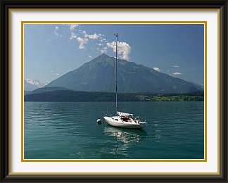
The Niesen is a prominent peak on the shores of Lake Thun in the canton of Bern. It forms the northern end of a ridge that stretches some twenty kilometres from the Albristhorn near Adelboden. Its pyramidal shape makes it a popular calendar subject and its summit is accessible by funicular.
 July's walks having gone quite well, the aim in August had to be to build on
the fitness achieved by aiming to do bigger vertical ascents every
time the weather allowed.
July's walks having gone quite well, the aim in August had to be to build on
the fitness achieved by aiming to do bigger vertical ascents every
time the weather allowed.
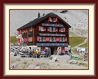
A good one to start the month, and one I had done often enough before was the Niesen, which had the advantage of being less than an hour's drive from Burgdorf. In addition, it is a relatively "quick" peak because of its conical shape extending all the way down to the plains, so that the trails climb steadily without any level bits. This is particularly true of the one which starts from the base station of the funicular railway and roughly follows it to the summit, a little over a vertical mile above. After parking in the car park of the Niesenbahn (nobody checks if you are using the train...), you ascend fairly monotonously through a few steep pastures, then a long spell of pine forest, then stonier low bush before rounding a ridge to zigzag alongside the railway below the summit. Mülenen village, where the car is parked, lies half hidden far below. Because of the long-established railway, this is a much visited peak, with plenty of walkers on the trail (including the lazy ones using the train one way), and hordes of grockles1 around the summit terrace and its restaurant. Needless to say, a summit shaped like this one has magnificent views in all directions, like that down to the village of Wimmis (here taken with a telephoto lens), from which another less frequented trail also leads to the top.

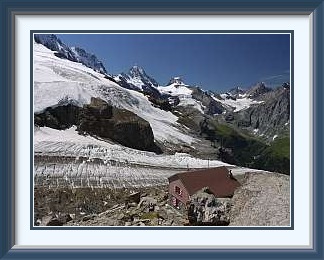
The Rottal Hut belongs to the Interlaken Section of the Swiss Alpine Club. It lies in very wild surroundings above the ice-filled bowl called the Rottal, "Red Valley", beneath the southern precipices of the Jungfrau.
 Regular sunny intervals in a summer warmer than average (like so many now...) meant that
conditions in the mountains were good. With the snow beaten well back and
the best weeks of the year for walking at hand, it was time to look
at much rougher trails.
Regular sunny intervals in a summer warmer than average (like so many now...) meant that
conditions in the mountains were good. With the snow beaten well back and
the best weeks of the year for walking at hand, it was time to look
at much rougher trails.
One that had always been on my to-do list over the years was that to the Rottal Hut. Lying in a glacier bowl under the western shoulder of the Jungfrau, the hut could hardly have a more different atmosphere from that of the Niesen. It's an ascent of more than 1800 metres from the village of Stechelberg in the Lauterbrunnen Valley.
After the usual hour or two through steep mountain forest, the path reaches more open ground where the track to the distant Silberhorn Hut forks off, a notably long and dif ficult path which for once really is as exposed as it looks from a distance. The scale of the cliffs can be judged from the two walkers in that last picture. They can just be made out, exactly at half height and 54% of the way across from the left. Not far above the fork, the Rottal path has been diverted west to avoid icefall, and now ascends an unusually long secured stretch up a cliff called the Bärenfluh. The steel cable doing the securing runs all the way to the skyline, but is hardly visible in the picture. The big blue arrow is, I suppose, designed to stop those who think there must be an easier way from continuing further along the foot of the cliff until they end up under the Rottal glacier and get flattened by the aforementioned ice. For the first time in the season, the path was high enough to cross a snowfield on the way into the lifeless Rottal ("Red Valley"), the bowl which collects the snow falling from the Jungfrau and the ridges to the west, all of which lie near 4000 metres. To the northeast of the hut, the Jungfrau's summit icefields hang over the cliffs a dizzy kilometre above and there are fine views westwards to the Doldenhorn and Blümlisalp. I enjoyed a couple of hours exploring around the hut before beginning the long trek back to the valley.
The Büttlassen is a mountain in the Bernese Alps. It lies just below the much better known Gspaltenhorn and can be climbed from the saddle called the Sefinenfurgga, in turn reachable from the Kien Valley to the west or Mürren to the east. Access to the summit is dif ficult and may depend on snow conditions in some years.
 Next on the menu was a place I had had my eye on for a long time, the peak known as the
Büttlassen. The drive to the starting
point is an adventure in itself, leading through the splendid Kien Valley and up
the world's steepest road to a parking place at Griesalp. Though there is a toll to be
paid2
beyond Kiental village, the road is well worth it.
Next on the menu was a place I had had my eye on for a long time, the peak known as the
Büttlassen. The drive to the starting
point is an adventure in itself, leading through the splendid Kien Valley and up
the world's steepest road to a parking place at Griesalp. Though there is a toll to be
paid2
beyond Kiental village, the road is well worth it.
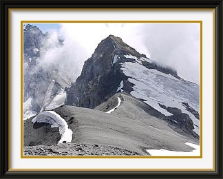
From Griesalp, it's a conventional walk along a private road at first, then on gradually steepening territory to a notch called the Sefinenfurgga. Shortly after that, you leave the marked path and ascend increasingly wild slopes until you reach a couloir, which I discovered years ago was the most practical way to get to the forepeak of the Büttlassen. That big slice of rock overhead in the middle of the couloir sways rottenly when you catch hold of it; if you are in company, you had better climb side-by-side, as it is hard to advance without sending chunks of rock bounding down the mountain. In my case, some of them were reaching the Gspaltenhorn Hut path four hundred metres lower down, fortunately at a time when there was nobody there to get clobbered. The forepeak has fine views of lower peaks nearby, and a day of thick but harmless cumulus made for picturesque views of the Schilthorn. I'd never gone any further in previous years, since the snowfield visible in the picture of the main peak looked as if it needed the crampons left behind in NZ, but this time I was feeling fit, and the snowfield seemed to have shrunk back from the ridge just a little. Climate warming, anyone? It was indeed just possible to skirt the hard old snow and reach the summit knoll at 3192 metres, which is made of frost-shattered rock like everything else around. The glaciation on the nearby Tschingelspitz is an indication that you are nearly as high as you can get without equipment in the Bernese Alps. Despite the altitude, it wasn't cold and, having left all the tourists behind at the Sefinenfurgga, I was able to enjoy a couple of peaceful hours in the clouds.
The Stockhorn is a peak at the northern edge of the Prealps in the canton of Bern. Its sheer northern face is prominently visible from the nearby town of Thun. It can be climbed most easily from Erlenbach village in the Emmental, from where a cable car runs to the restaurant just below the summit.
 After a short trip to Ireland it was time to try an old favourite, the
Stockhorn above the town of Thun.
Another peak which looks straight out over the lowlands, it has two approaches, one from the
Simmental on the south side and one from the villages near Thun on the north. The former is
the "tourist route" complete with cable car, so I picked the latter, an ascent I had done
more than a dozen times in the past.
After a short trip to Ireland it was time to try an old favourite, the
Stockhorn above the town of Thun.
Another peak which looks straight out over the lowlands, it has two approaches, one from the
Simmental on the south side and one from the villages near Thun on the north. The former is
the "tourist route" complete with cable car, so I picked the latter, an ascent I had done
more than a dozen times in the past.
Although once fully marked as a mountain path, this way up the Stockhorn is little frequented and parts have become hard to trace in recent years. After the usual stretch through the woods, you pass a summer alp hut where the farmer has always offered mountain cheese for sale. Higher up, there is one more alp hut, this time with loud but harmless dogs in the season, before the path winds its way onto the little Baachegg saddle and the final steep ascent to the peak. The view from the summit terraces over the plains is as fine as you would expect. I could see Niederstocken village a mile below, where my car was parked; in the exact centre of the picture, it's the second one above the little bus shelter. Looking the other way, you see the Hinterstockensee and the cable car down to Erlenbach in the Simmental. Some seven kilometres away, the Gantrisch could be seen in the early afternoon haze. From this distant perspective, the summit meadow and the network of paths leading to it can be made out easily. The conventional way up from the Gurnigel approaches from the left hand side under the skyline.
The Lämmeren Hut belongs to the Angenstein Section of the Swiss Alpine Club. It lies in the canton of Valais, in a stony valley to the west of the Gemmi Pass, with fine views to the pass and the Rinderhorn behind. It can be reached from Leukerbad in the Valais or from Kandersteg (much longer).
 The weather forecast was questionable when I decided to vary the menu
a little by going to the Lämmeren Hut
from Kandersteg. This isn't a particularly big ascent,
barely over 1300 metres, but the hut lies on the other side of the Bernese Oberland from
Kandersteg, so the total walking distance there and back is roughly 35 Km.
The weather forecast was questionable when I decided to vary the menu
a little by going to the Lämmeren Hut
from Kandersteg. This isn't a particularly big ascent,
barely over 1300 metres, but the hut lies on the other side of the Bernese Oberland from
Kandersteg, so the total walking distance there and back is roughly 35 Km.
After parking at the Sunnbüel cable car station, there's a slog through steep forest past the old Stockbahn cable car station six hundred metres higher up. This was closed in 1991 and its valley station was upgraded for a new lift terminating further into the valley towards the Gemmi Pass. The old one was tiny; from memory, it could only take about ten people. I remember sometime in the eighties arriving at the car park and seeing no queue at the ticket office. Good, I thought, I'll be lazy for once and use it. That idea lasted only until I got close enough to read the sign saying that tickets were being sold for the thirteenth next ascent. I walked up, as I should have done anyway.
The track continues for a time, now level, with dizzying views to the floor of the Gasterntal below, until it emerges into the Spittelmatte, a pleasant upland valley complete with jeep track. Such vehicles as there are must have been carried up suspended from the cable car, as there is no road access from either end. They service a hostel a few Km. further on which was once a customs post between two cantons. Beyond the hostel, a normal walking track continues ascending moderately for quite a distance until it reaches the Gemmi Pass at 2300 M. There you leave the crowds behind and head west through a valley of streams and gravel plains before the final short climb to the hut at 2500 M. It's a busy one, servicing a fairly large area of barren peaks and small glaciers, like the one nearest the hut, appropriately enough named the Lämmeren Glacier. It used to be the preserve of mountaineers with equipment, but the ice has retreated so much in the last few years that a sign at the hut now points to a blue hiking route up the middle of the picture to the summit behind. Climate warming again, and I fear we've seen nothing yet.
What really distinguishes this hut, though, is the nearby collection of dozens of cairns in a range of sizes and styles the likes of which I have never seen before... styles like the smurf, the art nouveau, the Tinguely, the phallic, the Tibetan and the Wizard of Oz. I was at this hut six years earlier, when I don't remember noticing any cairns, so it is all recent work.
On the long walk down the valley, the clouds thickened and brief rain fell, the only time in the whole season I had to don my rain gear.
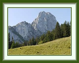
The Ärmighorn is a mountain on a ridge separating the Kien and Kander Valleys in the canton of Bern. Its prominent rocky summit is approached from the ridge to the north called the Giesegrat. Access to this from the Kien Valley is easy, but the summit is more dif ficult. It has splendid views in all directions.
 By the last day of August, mornings were getting a little cooler as I set off once again
to the Kien Valley to try another peak I had often wondered about, the
Ärmighorn, to the left
background in the picture. Conspicuously
visible from the tourist road to Kandersteg, its rocky upper faces never looked easy, and
the maps show no walking tracks to the top.
By the last day of August, mornings were getting a little cooler as I set off once again
to the Kien Valley to try another peak I had often wondered about, the
Ärmighorn, to the left
background in the picture. Conspicuously
visible from the tourist road to Kandersteg, its rocky upper faces never looked easy, and
the maps show no walking tracks to the top.
Viewed in the early morning light from the car park in Kiental village, the route goes up to the right of the prominent smaller peak to the barely visible ridge called the Giesigrat more than a thousand metres above. That smaller peak came in handy... it kept the sun off all the way up to a pretty and almost totally isolated alpine settlement in a bowl just below the ridge. The chalet and stalls were already closed for the winter. From the whaleback ridge, the peak looked easy, but on closer inspection, it wasn't. After the scree from hell, walking gave way to light climbing for the last stretch to the summit, which is a magnificent viewpoint with great views of most of the destinations already reached, like the distant Rottal Valley for example. In the photo, the Rottal Hut and the patch of snow below it, some 18 Km. away, are just discernible to the left of centre. Apart from the first couple of hundred metres above the village, I met not a single walker all day, so had plenty of peace to munch my sandwiches on the narrow summit ridge. In the clear upper air, Eiger, Mönch and Jungfrau were splendidly visible, and the weather remained perfect as I set off back down to Kiental village 1800 metres below.
Notes:
- grockle n. West Country (UK) term for tourist. ↑
- Subsequently abolished. See this report. ↑