


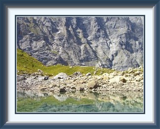
The tiny lake called the Oberhornsee lies in the upper reaches of the Lauterbrunnen Valley, well beyond the road end. It is shaded by the huge and forbidding Lauterbrunnen Wall, the range of ice-hung summits stretching south and west from the Jungfrau. A good path reaches it from the parking place in Stechelberg.
 At the beginning of the month, the weather forecast was a jumble, with
showers expected after sunrise, then sunny weather in the middle of the
day before the continuing warmth built up thunderheads by late afternoon.
The wife's friend, a Congenial Swiss Lady with some experience of
hillwalking, had been suggesting an outing, so this looked like a day
to avoid summits because of the lightning and pick instead a high
valley destination and a path which wouldn't presume unfairly on the
CSL's abilities.
At the beginning of the month, the weather forecast was a jumble, with
showers expected after sunrise, then sunny weather in the middle of the
day before the continuing warmth built up thunderheads by late afternoon.
The wife's friend, a Congenial Swiss Lady with some experience of
hillwalking, had been suggesting an outing, so this looked like a day
to avoid summits because of the lightning and pick instead a high
valley destination and a path which wouldn't presume unfairly on the
CSL's abilities.
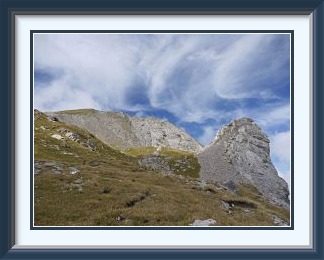
The choice fell almost immediately on a small lake called the Oberhornsee in the hindmost reaches of the Lauterbrunnen Valley. It was just about the only suitable place in the whole region to which I had never been, and there were a couple of mountain hotels on the way which would serve as refuges if a storm threatened. So it was that we parked the car at the end of the road in Stechelberg (tip: you can set the car park fee off against a drink in the hotel owning it afterwards) and set off. The lower stretches of the path run through some pretty pine woods before the Schmadribach Falls come into view, while at the head of the valley the Lauterbrunnen Breithorn dominates the landscape. Higher up, the track winds through mixed stony terrain alongside the upper reaches of the White Lütschine stream.
Arriving at last at the Oberhornsee, the first impression is of disappointment; it is tiny. However the towering rock walls and hanging glaciers of the peaks from the Breithorn to the Jungfrau give it a setting worth the trip. Flat stones in and around the lake provided plenty of picnic spots which the CSL and I duly enjoyed. The thunderheads never materialised, and the walk back down was in bright sunshine. The Obersteinberg Hotel at about 1800 metres was the occasion for a beer stop with a magnificent view from the Jungfrau to the Breithorn across the valley.

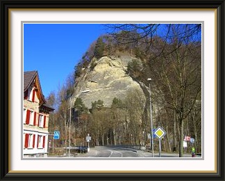
Just across the Emme River from the town of Burgdorf rise the near-vertical sandstone cliffs of the Gysnauflue. A pleasant walking track along their tops gives fine views across the town a hundred metres below.
 What, only 632 M? A typo, surely? No, a brief rainy interlude was just
ending and the wife wanted the car. A good day to hand it over, as
conditions even on the lower peaks wouldn't have been great. Fortunately,
a training hill lay not ten minutes from the apartment where we were staying.
The first of a row of crags overlooking the Emme as it flows through Burgdorf
collectively called the Gysnauflue,
it rises 94 metres directly from the road
at the edge of town. After an early and rather uncomfortable
stretch up a cobbled jeep track, the rest of the way is a
proper walking path making seven
pleasant zigzags up through the woods to a top with a
near-vertical (and totally unprotected!)
view down to the road where you
started. A dozen back-to-back ascents made for a total ascent of more than
eleven hundred metres and a pleasant three hours.
What, only 632 M? A typo, surely? No, a brief rainy interlude was just
ending and the wife wanted the car. A good day to hand it over, as
conditions even on the lower peaks wouldn't have been great. Fortunately,
a training hill lay not ten minutes from the apartment where we were staying.
The first of a row of crags overlooking the Emme as it flows through Burgdorf
collectively called the Gysnauflue,
it rises 94 metres directly from the road
at the edge of town. After an early and rather uncomfortable
stretch up a cobbled jeep track, the rest of the way is a
proper walking path making seven
pleasant zigzags up through the woods to a top with a
near-vertical (and totally unprotected!)
view down to the road where you
started. A dozen back-to-back ascents made for a total ascent of more than
eleven hundred metres and a pleasant three hours.
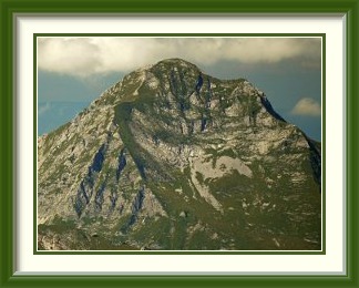
The Dent de Brenleire is a mountain in the Fribourg Prealps. It is approached from the town of Charmey via a narrow road to a parking place at the Gros Mont. Its upper slopes are open and steep.
 While I had over the years visited most of the prominent tops facing
out over the plains from the Bernese part of the Prealps, I had done
fewer of their cousins off to the southwest in the canton of Fribourg.
These are typically rockier and steeper, and the
Dent de Brenleire
and its even steeper twin the Dent de Folliéran are among the
most difficult. They had often caught my eye from the motorway north
of Bern as a pair of tiny pyramids on the horizon. Time to knock one
off, I thought.
While I had over the years visited most of the prominent tops facing
out over the plains from the Bernese part of the Prealps, I had done
fewer of their cousins off to the southwest in the canton of Fribourg.
These are typically rockier and steeper, and the
Dent de Brenleire
and its even steeper twin the Dent de Folliéran are among the
most difficult. They had often caught my eye from the motorway north
of Bern as a pair of tiny pyramids on the horizon. Time to knock one
off, I thought.
This Dent de Brenleire is usually accessed from the Gros Mont, not a mountain, but one of those quiet alpine valleys whose serenity is protected by an access road steep and narrow enough to deter the less confident motorist. At the parking place where the public road ends at Haut du Mont, there was a signpost to the peak. It was to be the only one, and the white-red-white marks along the whole path had not been repainted in a long time.
After a stint through pleasant, leafy forest, the path emerged into steep meadow just below the chalet of Croset Dessous. Here it became unfindable; the solution was to walk straight up about ten metres of grass to the chalet, then continue upwards on jeep tracks to two more chalets called Gros Croset and Brenleire Dessus. Above the latter, the track once more petered out on sloping alpine pastures until, fifty metres higher, it was suddenly discernible again. There were no more such dif ficulties as it crossed the grassy bowl between the two main ridges descending from the summit and headed for the leftmost skyline ridge, joining this just above its steepest point behind the chalet and the pine trees in the picture. Here a problem became evident. The track was now ascending smooth grooved knuckles of stone protruding from a very steep grassy ridge. There had been rain the previous day, and the ground had not dried out. Very soon, I encountered a step where my wet boots could get no purchase at all. On a sixty-degree slope, there was little chance of arresting a fall if I lost my footing.
Exceptionally, I decided to abandon the attempt not just for the day, but for the rest of the year. This was a path best done in dry summer conditions.
From my unsteady perch on the ridge, I could photograph most of my route past the three chalets below. Heading down again with time on my hands, I searched for the missing bits of the path. Sure enough, in the grass here and there where the path had once been well formed were some orphaned marker stones with faded paint. On the LK 1:25000 map for the area, the path is marked with the standard dotted line, interrupted for precisely the two short stretches where I couldn't find it. Hats off! Before the path reached the forest, there were fine afternoon views across the Gros Mont to the Dent de Savigny and its satellite peaks.
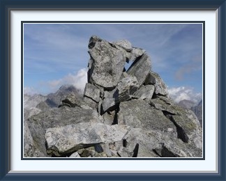
The Gross Schinhorn is a peak in the Lepontine Alps on the Swiss-Italian border just south of the Binn Valley. Access from the Geisspfad Lake is over trackless and stony terrain, not inordinately dif ficult. The summit is a Jenga tower of oblong boulders which looks as if it could topple into the valley at any moment.
 With another cold front looming, and the ever-increasing risk that
it would be the one to put snow on higher elevations which would
last into the next year, it was time to pick a reasonably high peak
while I still could. I chose the
Gross Schinhorn for no better
reasons than that it has a distinctly odd summit and I had not been
in the area before.
With another cold front looming, and the ever-increasing risk that
it would be the one to put snow on higher elevations which would
last into the next year, it was time to pick a reasonably high peak
while I still could. I chose the
Gross Schinhorn for no better
reasons than that it has a distinctly odd summit and I had not been
in the area before.
Unfortunately, it was a very long way from Burgdorf. As the Walking Friend was up for the expedition, it was necessary to take the car train across the Lötschberg, then drive down to Brig and pick him up from the train station before driving up the narrow Binn Valley road to its end at a hamlet called Feld. Even with perfect conditions, this took more than three hours, and we were only ready to start after ten o'clock. After the obligatory stint up steep pine forests, the cover grew thinner and there were views across the Rhône Valley to the high peaks of the Bernese Oberland. These views expand as the path becomes rougher in a landscape where the surrounding peaks were shedding boulders like dandruff. The path takes you as far as the Geisspfadsee before it continues over the low Grampielpass into Italy. This is the point where conventional walking turns into routefinding, as the peak is trackless and unmarked.
Going along the path to the back of the lake close to the pass and heading north avoided the steepest grass slopes. The grass soon came to an end below a row of impressive pinnacles and was replaced by the rubble which was to continue all the way to the summit and provide a considerable test of the knees. Despite finding no more than a couple of cairns in locations of no obvious significance, I arrived without much ado at the little Mittelbergpass and the first good view of the peak itself. The WF arrived at the pass minutes later but, unable to see me on the slopes above it, began to retrace his steps, leaving me to complete the ascent alone.
On top at last, the unusual nature of the summit was clear. One can only surmise that a few lucky boulders survived a collapse which removed everything else around; to the left and right, the drop is not far off vertical for hundreds of metres. One thing is clear... this summit "cairn" wasn't put up through human agency. The bigger stones weigh of the order of ten tons each. A nice touch is that the top two stones lie quite level, so that is is not dif ficult to stand or sit on the true summit. The view is as precipitous as one might expect, including the implausibly steep Klein Schinhorn nearby.
Back once again at the Geisspfadsee, I was reunited with the WF, who had made his way down the steeper grass slopes the ascent was designed to avoid. The late start and the time spent looking for the best way up meant that we descended from the lake near sunset, and the last part of the walk down through the pine forests had to be done flat out to reach the road before the light failed completely.
The Bunderspitz (also sometimes Bonderspitz) is a peak on the range separating Adelboden from Kandersteg, from either of which it is easily reached.
 In the second half of September the inevitable first cold
snap of autumn had happened. A cold front from the northwest had dumped snow
as low as 1500 metres; the question now was how fast that snow would
melt again. In the event, settled weather returned fairly quickly,
though with temperatures not as warm as before. The Congenial
Swiss Lady had a last free day before her work restarted and was
eager to get out, so a good, safe peak with no more than a little
summit snow would be required.
In the second half of September the inevitable first cold
snap of autumn had happened. A cold front from the northwest had dumped snow
as low as 1500 metres; the question now was how fast that snow would
melt again. In the event, settled weather returned fairly quickly,
though with temperatures not as warm as before. The Congenial
Swiss Lady had a last free day before her work restarted and was
eager to get out, so a good, safe peak with no more than a little
summit snow would be required.
Adelboden was a place I hadn't been back to in a few years, and the Bunderspitz, with a summit looking down both on Adelboden and Kandersteg, seemed about right. Driving up the main road below the town, we couldn't find a place to park the car at first. Then opposite a restaurant a row of spaces without any obvious restrictions loomed. As we were putting on our boots, I noticed a lady outside the restaurant glaring at us and muttering. The CSL went over to investigate; the parking spaces were indeed restricted, but the sign had been partly covered by a hedge. After an emollient conversation, the proprietress relented "since we had asked" and we could set off unworried.
Soon the view behind opened up to reveal Adelboden's mountain setting, with the Albristhorn on the left and the Gsür on the right; had the snow been a little higher, we would have chosen the Albristhorn for the trip. A longish slog up grassy slopes took us to the saddle between the Bunderspitz and the Klein Lohner, with patches of melting snow still dotted the sunless sides of the latter. In the other direction, virtually no snow remained on the sunny approach to the summit. There we encountered a handful of other walkers enjoying the magnificent panorama of the Blümlisalp chain and the Doldenhorn, with the distant Jungfrau at the extreme left.
The summit boasts as fine an example of the cairn fairy's work as you could wish for.
In a long string of fine, calm autumn days, this was the cloudiest. By afternoon, Adelboden was obscured below, but the ridge to the First was spared. As we prepared to descend, the clouds were draped artfully around the forbidding precipices of the Lohner and the distant Wildhorn,
Back at the car, we went across the road to the restaurant for a beer as a return for the free parking and ended up spending half an hour in pleasant conversation with the once hostile proprietress.
The Windegg Hut belongs to the Bern section of the Swiss Alpine Club. It lies in the canton of Bern, near the border with Uri. The easiest track to the hut starts from above Nessental on the road to the Susten Pass, but it can also be reached from Guttannen on the Grimsel Pass road.
 It was time for a break in the peak bagging, and a look at
something still out of the ordinary in the Alps. The
Triftbrücke suspension bridge
below the Windegg Hut was built in 2005 for mountaineers needing to
get to the much more remote Trift Hut. The old path
crossed the lower stretches of the Trift Glacier, but these
have now melted entirely, leaving a substantial lake in their place.
Where a glacier tongue once squeezed between walls of rock, a bridge
more than a hundred and fifty metres long has been constructed, soaring
nearly a hundred metres above what is now the Triftwasser stream.
It was time for a break in the peak bagging, and a look at
something still out of the ordinary in the Alps. The
Triftbrücke suspension bridge
below the Windegg Hut was built in 2005 for mountaineers needing to
get to the much more remote Trift Hut. The old path
crossed the lower stretches of the Trift Glacier, but these
have now melted entirely, leaving a substantial lake in their place.
Where a glacier tongue once squeezed between walls of rock, a bridge
more than a hundred and fifty metres long has been constructed, soaring
nearly a hundred metres above what is now the Triftwasser stream.
There was space to park the car at the terminus of the tiny Triftbahn cable car on the Susten Pass road. With cabins holding only eight people, this provides a means for walkers who don't mind queueing to reach a small dam about halfway to the bridge. Walking up instead provides views of those tiny Triftbahn cabins as they skirt the deep cleft cut by the Triftwasser along its lower reaches. This part of the path has its tame and wild sections, but ascends about 150 metres above the upper cable car station before dropping down to it, a debt which has to be repaid later.
As the path approached the bridge, there was more evidence of the cairn fairy at work, though not very durable looking work in this case. The bridge itself is well worth the trip, with fine views of it from the rocky terraces at the eastern and the western ends. It is a very popular destination, with something of a picnic atmosphere around the supports on both sides.
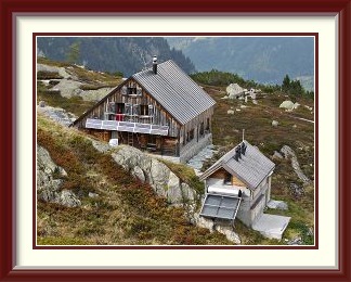
From the bridge to the hut, there is a choice of paths. I chose the steeper option, the "Chetteliweg", which has a chain for security on bare rock slopes. This looks worse than it is, but does require at least a T3 rating; all the rest of the walk, though quite steep at times, is no worse than T2. The Chetteliweg crests a final rise, and you look down at the Windegg Hut surrounded by autumn colours. This hut probably does well from the numerous daytrippers coming to see the bridge; seen from the north, it has a splendid backdrop of the Tierberg peaks.
After a brief snack stop by the hut, it only remained to take the steep direct path called the Stotziger Weg down to rejoin the main bridge track and then, after the cable car station, repay those 150 metres on the way back to the car.
The Trient Hut belongs to the Diablerets section of the Swiss Alpine Club. It lies in the canton of Valais near the French border, at the eastern end of the Mont Blanc Chain and enjoys spectacular views across the ice-filled Plateau du Trient to the pinnacles along the border. A spectacularly unsympathetic concrete extension was added to the original stone hut in the 2000s.
 At the end of the month there had been ten consecutive days of calm
autumn weather, with morning fogs, occasional outbursts of cumulus and
abnormally warm daytime temperatures. The snow from that first cold snap
would be all but completely gone again now. It was a matter of regret for
the Walking Friend that he had missed the ascent of the Wasenhorn in August, so I
looked for walking paths above three thousand metres in the Valaisian Alps.
There weren't that many within easy reach, but the one to the
Trient Hut, with its upper reaches all south-facing, looked promising.
At the end of the month there had been ten consecutive days of calm
autumn weather, with morning fogs, occasional outbursts of cumulus and
abnormally warm daytime temperatures. The snow from that first cold snap
would be all but completely gone again now. It was a matter of regret for
the Walking Friend that he had missed the ascent of the Wasenhorn in August, so I
looked for walking paths above three thousand metres in the Valaisian Alps.
There weren't that many within easy reach, but the one to the
Trient Hut, with its upper reaches all south-facing, looked promising.
A predawn start meant that the WF was picked up and we were parked at the start of the trail in the village of Champex just after eight a.m. The path began by hairpinning steeply up through forest and a rockslide, so that we had gained seven hundred metres in the first hour and a quarter. That was to be the end of the quick ascent, however. The path entered a long horizontal stretch across slopes of grass and boulders towards the peak of Le Portalet on the horizon. When the path began to climb again, one of the peaks of the Arpettes Chain to the north revealed a hitherto unsuspected cubist side to the Alps. After the last grassy bowl had been left behind, the Orny Hut came into view, perched majestically above the tongue of the Orny Glacier and its lateral moraine.
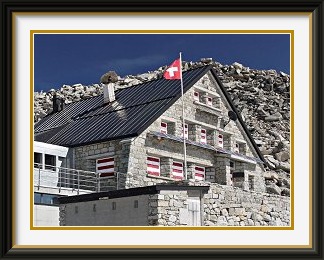
Beyond this first hut, the landscape is one entirely of rubble and ice. The path is now of ficially a route, with blue paint markings instead of the white-red-white ones. It once went onto the glacier, but this has shrunk so much that the way has been rerouted exclusively through the boulder fields. Here and there, it involves clambering over rocks like these, but one rock step has had iron steps and handholds installed to simplify things. Arrived at last at the Trient Hut, we were able to contemplate the least harmonious hut extension either of us had ever seen. Tearing our eyes away at last, we were able to enjoy a spectacular alpine panorama across the Trient Ice Plateau, including the Aiguille du Tour and the Aiguille du Chardonnet, the latter entirely in France. Frost shattering on nearby tops produced some spectacular horizons like this and this.
The length of the return journey meant that we could only remain at the Trient Hut for an hour; it had closed for the winter anyway. On the way down, there was a fine view of the Grand Combin, one of Switzerland's more remote 4000ers. As we descended the original steep stretch, the sun was setting and it was dusk by the time we reached the car.
This walk brought to a close another rewarding season in Switzerland, where the weather didn't prevent a single one of fourteen outings in two months and was excellent for most of them1. This success rate is, of course, only available to those who can choose their days freely!