


Piz Minschun is a mountain in the Silvretta Alps overlooking Scuol in the Lower Engadine. Access from the village of Ftan is over farm tracks to Alp Clünas, after which a more conventional path leads past the tiny Lai (Lake) da Minschun up to the summit ridge. The peak has fine views in all directions, extending to the southeast as far as the 3905-metre Ortler over the border in Italy.
 The decision last year to go straight to the Upper Engadine as soon as
we arrived and start walking there had worked well, so we decided to
repeat the exercise in 2019, but in the Lower Engadine instead of the
upper part. With a trip to Ireland already booked for the last two days
of the month, there would be at most a week available, so I would be
pushing my luck to get three walks done, but two were certainly on the
cards. So, just four days after we had arrived, we were duly set up in
our capacious new tent in the TCS campground in Scuol. The old one had
finally started to disintegrate at the end of our stay in San Moritz last
year after 28 years of faithful service, and the new one promised a more
comfortable life, being easier to put up and having more head space.
With another heatwave in progress, we looked forward to escaping the worst
of it at 1300 metres.
The decision last year to go straight to the Upper Engadine as soon as
we arrived and start walking there had worked well, so we decided to
repeat the exercise in 2019, but in the Lower Engadine instead of the
upper part. With a trip to Ireland already booked for the last two days
of the month, there would be at most a week available, so I would be
pushing my luck to get three walks done, but two were certainly on the
cards. So, just four days after we had arrived, we were duly set up in
our capacious new tent in the TCS campground in Scuol. The old one had
finally started to disintegrate at the end of our stay in San Moritz last
year after 28 years of faithful service, and the new one promised a more
comfortable life, being easier to put up and having more head space.
With another heatwave in progress, we looked forward to escaping the worst
of it at 1300 metres.
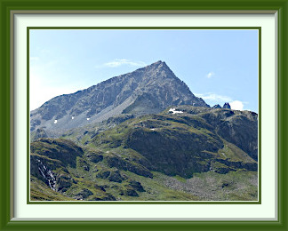
On a fine, warm morning, it was a pleasantly short drive to the little village of Ftan at the foot of Piz Minschun, a good starter peak, being high enough to be interesting, but not particularly difficult. There I found plenty of parking at the base station of the Prui lift. The first eight hundred metres of the ascent were up farm roads and tracks, closed to public traffic or I would have driven them. It was a somewhat tedious two hours before I finally reached a more congenial Alpine track, where summer flowers refreshed the spirit. Here at last, Piz Minschun came into view, though its summit (near the middle of the picture) was still out of sight. White-red-white markings led to a tarn, Lai da Minschun, still half covered with winter snow. Beyond this, the track, no longer marked, led more steeply up to a saddle where the panorama to the north burst into view. From here, the Lai da Minschun was visible far below and the way to the summit was clear.
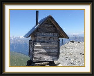
Despite the altitude, conditions on the summit were not at all refreshing, perhaps close to 20°C. Now and then a brief gentle breeze gave momentary relief, but what was noticeable was the number of frequent twisters, little mini-tornadoes flinging the fine scree around harmlessly. There must have been half a dozen while I was there. On this clear day, there were splendid views in all directions. Not far to the north the Fluchthorn on the Austrian border looked like quite a challenge. The most distinctive thing about Piz Minschun, however, was the nicely crafted miniature hut holding the summit book. How does it weather the winter storms? Back at the saddle, under a sky filling with aircraft trails, the distant bulk of the Ortler (3905 M.) in Italy was framed between the peaks on the south side of the Lower Engadine near Scuol.
Soon I was back below the lake and starting the long and tedious walk down those farm roads. The farmers had mown their grass for silage while I was on the summit and were busy loading it from the road onto their transporters. Beyond the last of them, there was the sound of a noisy petrol motor more familiar from city gardens. Sure enough, a farmer's wife was using a leaf blower to clear the last cuttings from the gravel road, raising a huge cloud of dust in the process. Only in Switzerland!

The Flüela Schwarzhorn is one of a pair of peaks (the other being the Flüela Weisshorn) which flank the Flüela Pass road at its summit. The track to the summit begins from the road a little east of the pass. With a Postauto stop for it, the track is very popular, and a relatively easy way to ascend a mountain of considerable height with good views in all directions. The track is also used by mountain bikers.
 The day before this walk, the temperature in Scuol reached the highest value
ever measured there... 33.8°C. So much for our intention to escape the
heat on the plains!
The day before this walk, the temperature in Scuol reached the highest value
ever measured there... 33.8°C. So much for our intention to escape the
heat on the plains!
The weather remained warm, but with an increased threat of rain, acceptable conditions to drive almost to the top of the Flüela Pass and ascend yet another Schwarzhorn. This was a somewhat lazy option, as the high start meant an ascent of barely over 800 metres, but the mountain was tall enough to be interesting anyway. After a drive of about 45 minutes, I secured one of the last two places remaining in the roadside car park dedicated to the track; with its own Postauto stop also, this would not be a lonely walk.
The track skirted a bluff and headed up the Radönt Valley, with the peak enticingly visible in the clear morning light. Higher up, walkers were inconvenienced (as mountaineers' jargon would put it) by numerous snow patches, rather more than I would have expected at the altitude. Perhaps this part of Switzerland had had a particularly snowy spring.
From the Schwarzhornfurgga saddle, there was a steeper track for the final 250 metres or so to the summit, with fewer snow patches along the way. Luckily, however, a couple had survived right on top, so that I was able to chill my lunch drink. From the summit, there is an excellent view down to the installations of the Flüela Pass and the road descending to the NW. There was the regulation summit cross; this one had been struck by lightning and nearly half its mass had been blasted away. The remains of the crossbeam had been tied back on with old climbing rope.
As expected, I was far from alone on the summit. Apart from a smattering of local walkers, there were people from nearby Austria and two from Norway. No fewer than three couples brought large dogs with them. Then, as I was munching my sandwiches on one of the last comfortable spots left, one of these arrived. While it was not the first time I had seen people carrying bicycles, (...see the Mettelhorn or the Augstbordhorn), it still seemed like a lot of work to enjoy the scenery that way. On the other hand, serious skiers often carry their gear up and have even less time to enjoy the view on the way down, so everyone to his own, I guess!
As time wore on, thundery-looking cloud moved in over the choppy sea of peaks to the northeast, and it was time to descend. In the event, the journey down the softer scenery of the lower valley remained pleasant, and though a few drops of rain fell as I reached the car, it is unlikely that those still on the summit were "inconvenienced".