


The Widdergalm is a mountain in the Fribourg Prealps lying between Boltigen in the Simmental and the Schwarzsee in Canton Bern. The most straightforward approach is from the Simmental side, where a motorable road leads from near Boltigen to a valley head called the Chlus offering a good parking spot at the end of the public road. The mountain is not much visited, and tracks on the upper slopes are a little vague at times.
 The Covid-19 years were over at last, and international travel from New
Zealand was once again possible. While I had had some exercise on a 500-metre
ascent within easy reach of my home, I was not getting any younger, and my
fitness would certainly have suffered. The challenge would be to find some moderately
easy peaks in the Bernese Oberland which I had not already done. Of the few such
peaks, the Widdergalm had the advantage of being in a familiar area not too far
from home.
The Covid-19 years were over at last, and international travel from New
Zealand was once again possible. While I had had some exercise on a 500-metre
ascent within easy reach of my home, I was not getting any younger, and my
fitness would certainly have suffered. The challenge would be to find some moderately
easy peaks in the Bernese Oberland which I had not already done. Of the few such
peaks, the Widdergalm had the advantage of being in a familiar area not too far
from home.
The weather had been hot and sunny since our arrival in Switzerland at the start of the month. Now some cooler air was moving in, and there was a chance of thunderstorms by afternoon, but I judged that the risk was small enough; a little rain might even be preferable to the baking afternoon sun. The journey from Burgdorf was uneventful, and the road leading off the Simmental towards the mountain was easy enough, with only the last few hundred metres along the valley head called the Chlus a little rough. At its end was an ample parking area right by the start of the track.
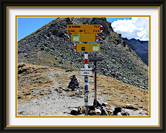
The first five hundred metres of the ascent led up a well-defined but stony track out of the Chlus to a saddle at Uf Egg. The slopes faced directly into the morning August sun, and the heat was exhausting. Beyond the saddle, the path joined a jeep track which scarcely descended at all as it passed above a small and not very picturesque lake, the Walopsee. Continuing along this path would have taken me to the Kaiseregg. A short distance along this stretch, I nearly missed the marker stone for the much less well-defined track leading up to the farm chalet at Buufel. The track skirted this chalet on three sides, with the last turn being easy to miss, before resuming its ascent to Vortel (two nondescript chalets) and a signpost just above two thousand metres at a place called Langel. There was no pointer to the Widdergalm, the closest point of note around; one arm of the signpost had been covered up, but it was not pointing towards the peak.
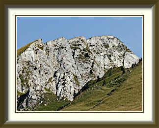
There was no reason for concern, though, as the Widdergalm's summit was unmistakable across the grassy slopes. Oddly, there was no detectable track leading from the signpost in that direction, but as I crossed the grass towards a fence with its stile and guard dog warning sign (the small white rectangle in the picture), one slowly took form. As ever, this was correctly represented in the LK with a break in the track line at just the right place. Beyond the fence, there was a stretch through thick, low vegetation before the final pleasant ascent to the summit.
Like so many of its neighbours, the mountain had a big summit cross, but this one had a small shrine affixed to it, with rather tired-looking contents. There was lusher grass growth around the top than on most of its peers. Perhaps farm animals were unable to reach it, for there was a welcome absence of droppings, unlike on its neighbour, the Schafberg. The tall grass gave way abruptly to near-vertical drops on the mountain's eastern side overhanging remote alpine meadows in a narrow corner of Canton Fribourg that projects into Bernese territory.
The weather had threatened thunder earlier, but in the end there was nothing more than cloud and momentary drizzle. The Widdergalm is near enough to the edge of the Prealps that there are views to the lowlands and the city of Fribourg, with the Jura mountains on the horizon, but the summer haze defeated photography.
Descent was by the same route. The track back down into the Chlus managed still to be in the sun, and was even hotter than in the morning. I found myself wishing for some of those thundery showers, though without too much emphasis on the thundery part.

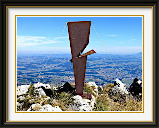
The Homad (or Hohmad) is part of the Stockhorn Chain, about halfway between the Stockhorn and the Gantrisch. A modest, grassy summit, it is distinguished mainly by an iron sculpture at its summit. While it can be approached from the valley on either side, it is best reached from the starting points for the Gantrisch, giving a walk which is more horizontal than vertical.
 A brief thundery period after the first walk had quickly given way to fine and
stable weather. The Congenial Swiss Lady was up for a walk; as neither of us
was particularly fit yet, a fairly easy peak was required. With most of these
for miles around already done, we settled on the Homad. Though a fairly modest top
in the chain extending from the Stockhorn westwards to the Gantrisch, it would still
have worthwhile views. We set off early for the big car park at the foot of the
Gantrisch.
A brief thundery period after the first walk had quickly given way to fine and
stable weather. The Congenial Swiss Lady was up for a walk; as neither of us
was particularly fit yet, a fairly easy peak was required. With most of these
for miles around already done, we settled on the Homad. Though a fairly modest top
in the chain extending from the Stockhorn westwards to the Gantrisch, it would still
have worthwhile views. We set off early for the big car park at the foot of the
Gantrisch.
The track began as a motorable road towards the farm settlement at Obernünenen. From here, the Homad's northern side was visible; however, our path would not approach it directly on its way to the Stockhorn, but head to the right of the view in the photograph and over the Leiterenpass in order to traverse the southern side of the range.
Over the pass and on the sunny side of the range, there was a fine view back to the two neighbours. Compared to the same view twelve years earlier, not much had changed... there was perhaps a little more erosion in places, and the pines had grown a bit. Ahead of us, the track meandered amiably across the sunny slopes, with fewer walkers than one might have expected on such a sunny day.
Less than an hour later, we left the track towards the Stockhorn and turned up easy grassy slopes towards the summit. The summit furniture here was most unusual, an iron sculpture, a modernist take on a cross perhaps, although crosses are not usually present in this part of Switzerland. We could sit at its foot and munch our sandwiches in the still perfect weather. To the east, the track we had left could be seen wending its way towards the Stockhorn, with the Niesen visible beyond it and the usual Bernese Oberland suspects lining the horizon.
As we descended from the Leiterenpass back to the car, there were some striking views in the afternoon light of the Nünenen's cliffs. A next-door neighbour of the Gantrisch, it has no easy ascent; all routes to the summit are rated T6.
Piz da l'Ova Cotschna is an outlier of the Rosatch Chain above San Moritz. It affords good views of the town directly below and of the Rosatch summits in the opposite direction.
 A few days after the last walk, I decided for old times' sake to go camping with the wife;
a place with good walking opportunities would add to the experience. So we set off on the
longish drive to the Upper Engadine, where we knew of a camping ground just outside
San Moritz with lots of peaks nearby. The weather the next day was looking dubious, and
I decided not to try anything, since our base was already at 1800 metres, and heading for
summits around 3000 metres could be challenging in a storm. In the event, conditions
improved somewhat before midday, so I decided to try Piz Mezdi, which was part of the
Rosatch Chain rising steeply from the edge of San Moritz Bad, the southern part of the town.
Changes of mind so late in the day are usually a bad idea, but with no driving
involved, I reckoned that the downside of any failure was small.
A few days after the last walk, I decided for old times' sake to go camping with the wife;
a place with good walking opportunities would add to the experience. So we set off on the
longish drive to the Upper Engadine, where we knew of a camping ground just outside
San Moritz with lots of peaks nearby. The weather the next day was looking dubious, and
I decided not to try anything, since our base was already at 1800 metres, and heading for
summits around 3000 metres could be challenging in a storm. In the event, conditions
improved somewhat before midday, so I decided to try Piz Mezdi, which was part of the
Rosatch Chain rising steeply from the edge of San Moritz Bad, the southern part of the town.
Changes of mind so late in the day are usually a bad idea, but with no driving
involved, I reckoned that the downside of any failure was small.
The track to the peak began immediately after the last buildings of the town, and in its lower stretches was at times nicely laid out with paving stones through some surprisingly lush vegetation for the altitude. I did not have to ascend far before there were good views of the wealthy lakeside part of San Moritz and the ranges to its north, including the familiar Piz Ot.
It was after two o'clock by the time I came to a fork in the track at 2600 metres, with a signpost pointing left towards Piz Mezdi and right to Piz da l'Ova Cotschna, a good two hundred and fifty metres lower. That late in the day, and with the weather still looking unstable, it seemed wise to settle for the latter; it would still have excellent views.
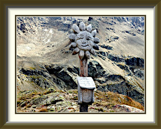
The track then crossed flattish ground with attractive russet colours on its way past the little Lej (lake) da l'Ova Cotschna to the nearby summit, barely a hundred metres higher. A few metres below the summit, there was a stout bench cut from massive tree trunks, facing a view along the highest part of the Upper Engadine Valley to its head at Lake Sils. On top, I was greeted by a welcome change from the usual crosses, a carved wooden sunflower with the wooden summit book holder attached.
The summit was a pleasant place to eat sandwiches and enjoy views of the Engadine in both directions. Down the valley to the northeast, still more than a mile above sea level, were the villages of Celerina and Samedan (with the latter's airport for the rich and famous). Dominating the horizon was the great flat stump of Piz Kesch, and just in front of it was the less rugged top of Piz Blaisun. Not far below, the track wound its way past the Lej and its smaller reddish sibling. Perhaps the colour of the smaller tarn is what gave the mountain its name, which means Red Water Peak in English.
By mid afternoon, the weather towards the Maloja Pass was becoming gloomier, so I didn't dally and was back in San Moritz Bad before six. In the event, the rain did not arrive until the early hours of the following day.
Piz Lunghin is a mountain in the Albula Alps. It overlooks Maloja Village and the pass of that name at the head of the Upper Engadine Valley. The saddle to the north of the summit is the location of the triple watershed from which rivers flow to the North Sea, the Adriatic and the Black Sea.
 A couple of damp days after the last walk were followed by a slow improvement, and by the
Sunday, a little morning fog gave way to locally cloudless conditions. It was just a short
drive to the very head of the magnificent Upper Engadine Valley and a parking spot at
the southern end of Lake Sils, where the track to Piz Lunghin promised an interesting day.
A few other parked cars indicated that I would not be alone.
A couple of damp days after the last walk were followed by a slow improvement, and by the
Sunday, a little morning fog gave way to locally cloudless conditions. It was just a short
drive to the very head of the magnificent Upper Engadine Valley and a parking spot at
the southern end of Lake Sils, where the track to Piz Lunghin promised an interesting day.
A few other parked cars indicated that I would not be alone.
I didn't need to go far up the track before the view stretched in the morning sunshine over the buildings of Maloja to the Cima da Murtaira and the distant Bergell Range. The latter was the site of a tragedy when eight walkers disappeared under a huge fall of rock from its highest peak, Piz Cengalo, in 2017. A mudflow reached the village of Bondo on the road south from the Maloja Pass and caused extensive damage. Experts were at first puzzled how a rockfall could turn into a flow of mud and it was some time before they concluded that three million cubic metres of rock had struck the Cengalo Glacier with such force that more than half a million tons of water had been pressed out of it.
A conventional ascent up grassy slopes followed until the track crossed a small stream an hour later. This small stream is in fact the very beginning of the Inn river, which flows for more than five hundred kilometres through Austria and Germany to join the Danube at Passau as its seventh longest tributary.
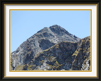
After another half an hour or so Lake Lunghin, the source of this stream, came into view. From here, Piz Lunghin's summit and its slopes of rubble were visible above.
A short ascent from the back of the lake took me to Pass dal Lunghin, the saddle to the north of the peak. Unexceptional in itself, this place is notable for being one of only a handful of triple watersheds in Europe, with rainfall around this spot flowing to the North Sea, the Black Sea and the Adriatic. The signpost at the pass made sure that walkers were enlightened.
From the saddle, the track became rougher through at times steep rubble, and a couple of big steps on the steep ground justified a rating of T4. This didn't last long, and soon it was time to crack open the bubbly, or at least the energy drink. There were others on the summit, though most people were content to reach the saddle. One couple had even brought a dog all the way.
Piz Lunghin is, not unnaturally, a great viewpoint for the highest part of the Upper Engadine Valley, with its two uppermost lakes, Silvaplana and Sils. Right at its foot lies Maloja Village, where the grandiose Upper Engadine ends, not in a circle of mountains, but in a sudden drop over the Maloja Pass towards the Swiss border and the town of Chiavenna in Italy, some twenty-five kilometres away. I had taken the wife there for lunch just the previous day. It lies nearly fifteen hundred metres lower than Maloja and has a very different atmosphere to that of the Engadine towns.
Below the summit, a shortcut over steep shale let me skip the saddle and go straight down to Lake Lunghin. In the perfect weather, the views were delightful alongside the baby Inn on the descent to the roadside car park.
Fuorcla Sesvenna is a pass between the remote hamlet of S-charl near Scuol in the Lower Engadine and the Schliniger Tal or Valle Slingia in Italy. It offers walking of no great dif ficulty in a landscape of stony peaks reaching above three thousand metres.
 After a week enjoying San Moritz's high prices, we had moved down to the Lower
Engadine for a change of scenery. Scuol is my favourite town in Graubünden,
flanked by particularly striking peaks on its southern side and with a less
aggressive tourist scene than its more expensive neighbour. Its well-equipped campsite
lies near the beginning of a road up a side valley along boulder-filled river flats
between towering walls of rock. At the end of this road lies S-charl, one of the
remotest hamlets in Switzerland and a jumping-off point for walks towards the nearby
border with Italy.
Its village centre consists of a
handful of buildings with the thick walls and small windows that indicate that
winters are really cold.
After a week enjoying San Moritz's high prices, we had moved down to the Lower
Engadine for a change of scenery. Scuol is my favourite town in Graubünden,
flanked by particularly striking peaks on its southern side and with a less
aggressive tourist scene than its more expensive neighbour. Its well-equipped campsite
lies near the beginning of a road up a side valley along boulder-filled river flats
between towering walls of rock. At the end of this road lies S-charl, one of the
remotest hamlets in Switzerland and a jumping-off point for walks towards the nearby
border with Italy.
Its village centre consists of a
handful of buildings with the thick walls and small windows that indicate that
winters are really cold.
An early start guaranteed freedom from oncoming traffic on the narrow road, and soon I was setting off along one the two exits from S-charl into the mountains. The first hour or so was up a farm track heading north-east along the young Sesvenna River between pine forests, not my favourite type of walking route. Just after the last habitation at Alp Sesvenna, the track turned east and crossed the dry bed of a stream draining the high plateau near Piz Lischana above. The crude bridge of tree trunks across the dry bed didn't inspire confidence. What would it be like to cross it with the stream in spate?
Beyond the bridge, the track wound its way through patches of low forest and then bush before the last of the vegetation gave way to a wide, grassy valley in the upper part of the Val Sesvenna. For a couple of kilometres, the track rose only gently before a modest rise led to one more grassy terrace. Then a steep and rocky section exited to a tiny mountain tarn with the rather grandiose name of Laj da Sesvenna below the rubble fans coming down from the higher slopes of Piz Sesvenna and its satellites.
The rest of the ascent up once again partially grassy slopes led fairly quickly to the Fuorcla Sesvenna itself, a broad saddle between Piz Rims and Piz Sesvenna. There were a few other walkers there, as it is also reached by an easy path from the Italian side. Being the border between the two countries, the pass has one of the sporadic marker stones which dot the border every few kilometres in this part of the world.
A short distance away to the south lies Piz Sesvenna, the highest point of the extensive Sesvenna Group, which consists of essentially all the mountains on the south side of the Lower Engadine. Piz Sesvenna is walkable with some difficulty, but despite its prominence is not visited that often because of its remoteness. From the Fuorcla, the view eastwards over a nameless tarn extends as far as the distant Weisskugel, at 3738 metres, the highest point on the Italian-Austrian border. Looking back the other way over the approach route, S-charl was far out of sight, but there was a fine view of the numberless stony summits of the Western Sesvenna Group. Its highest summit, Piz Pisoc, is just about doable by experienced walkers, but I suspect that many of the others are not.
There was no mobile phone reception at the pass, nor was there any as I headed back down the way I had come. Indeed, this walk was notable in 2022 for having no trace of a mobile phone signal anywhere along its length.