


The Wittenberghorn is a mountain in the Vaudois Prealps lying between Gstaad and the town of Les Diablerets. Walkers can approach it from above Feutersoey to its east on the Col du Pillon road. There are no paths on its western slopes.
 After our stay in the Engadine, a brief holiday in nearby Tyrol had brought no
walking opportunities due to poor weather. A shame, as the Ötztal offers
endless peaks and walks nearly as well marked as in Switzerland. Back in Burgdorf,
changeable weather suppressed the urge to get out for a while, but by the middle
of the month I felt that I needed to get back in gear. But where to go? With so many
of the nearby summits done, some many times, the decision was becoming ever more
difficult. Perusal of my walking maps led after a while to a peak I for once knew
nothing about, the Wittenberghorn. Lying south of Gstaad off the road to the Col du
Pillon, it would require a slightly tedious drive, there being no fast routes from
the Bern area to Gstaad. On the other hand, as I had walked in the area only about
twice in the last twenty years, there would be some novelty value.
After our stay in the Engadine, a brief holiday in nearby Tyrol had brought no
walking opportunities due to poor weather. A shame, as the Ötztal offers
endless peaks and walks nearly as well marked as in Switzerland. Back in Burgdorf,
changeable weather suppressed the urge to get out for a while, but by the middle
of the month I felt that I needed to get back in gear. But where to go? With so many
of the nearby summits done, some many times, the decision was becoming ever more
difficult. Perusal of my walking maps led after a while to a peak I for once knew
nothing about, the Wittenberghorn. Lying south of Gstaad off the road to the Col du
Pillon, it would require a slightly tedious drive, there being no fast routes from
the Bern area to Gstaad. On the other hand, as I had walked in the area only about
twice in the last twenty years, there would be some novelty value.
The journey via the Simmental to the hamlet of Feutersoey and the side road towards the mountain took an hour and fifty minutes. This side road, like many of its kind, is maintained by the local Gemeinde, and there is a charge for non-residents towards its upkeep. Most of these are paid by buying a day ticket either at a roadside machine or in the nearest small shop, but this one had a novelty, an automatic barrier which lifted on insertion of the required five francs into the machine. The fee bought me access to a narrow but decent road leading to the Arnensee Reservoir. Half a kilometre before the reservoir, a farm track leading towards the mountain turned off at Schüpfenweid, and there was enough space at the junction to park the car.
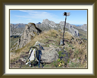
The first four hundred metres of the ascent led up a farm track of no great interest through patchy woodland until it reached the last farm buildings below the peak at Ussere Witteberg. With its location at the lip of a grassy bowl extending all the way down from the summit of the Wittenberg, the farmer had built an impressive avalanche barrier to part the snow just above the house. The track did not head up the bowl, but instead skirted it on the right, becoming rather stony for a time. Above the stony bit, it doubled back towards the east ridge of the mountain, and had two stretches that were unmarked (as ever faithfully represented in the LK), but the way to the summit was obvious. Just below the top, the track became briefly exposed and tricky when it left the ridge to sidle across the mountain's northeast face, barely managing to reach the T3 rating I have given it.
The Wittenberghorn's grassy summit was quite narrow, but there was space enough to sit down and enjoy the view, and a very fine view it was. To the south, it extended over the Arnensee to the Oldenhorn on the other side of the Col du Pillon. To the west, the view extended over the hamlet of L'Etivaz on the Col des Mosses Road to the curiously flat-topped Rochers de Naye above Montreux. Behind the Rochers, the distant crests of the Jura Mountains along the French border were gratifyingly visible; they are usually lost in haze during the warmer months. Far off to the southwest, Mont Blanc reared its enormous bulk behind the peaks lining the Rhône Valley.
With time to spare, I took the summit book out of its holder, expecting little beyond endless boilerplate remarks about the track and the weather. In fact, it was better than most, with quite a few charming illustrations by walkers who had evidently had at least much time as I did on the summit.
Heading back down the east ridge of the mountain, I encountered something still a bit surprising in Switzerland, a ruin with a view. Storm damage? Roof crushed by snow? Something to speculate about on the way back to the car.

The Moléson is a mountain in the Fribourg Prealps which overlooks the lowlands north of the eastern end of Lake Geneva. With a cable car running up its north side, its walking tracks are well frequented.
 A week of mixed weather had given way to a series of sunny days, and the month was
advancing. It was time to notch up another walk. A search through the usual suspects
didn't turn up any inspiring options until it occurred to me that there was one
mountain where I had been quite a number of times over the years without ever
catching a day of really good weather. Except, that was, for one memorable day when
I forgot to bring my camera! Despite its modest height, this peak overlooks the
Mittelland1
more prominently than any other in the Prealps; it is visible from as far away as
the motorway north of Bern. Its name is the Moléson.
A week of mixed weather had given way to a series of sunny days, and the month was
advancing. It was time to notch up another walk. A search through the usual suspects
didn't turn up any inspiring options until it occurred to me that there was one
mountain where I had been quite a number of times over the years without ever
catching a day of really good weather. Except, that was, for one memorable day when
I forgot to bring my camera! Despite its modest height, this peak overlooks the
Mittelland1
more prominently than any other in the Prealps; it is visible from as far away as
the motorway north of Bern. Its name is the Moléson.
From the large car park for users of the mountain's tourist facilities, the way initially follows a jeep track leading to farm buildings and the cable car station high above. So far, so familiar, but a short distance up this track, I was confronted by a sign directing walkers off to the left over meadows. Somewhat baffled, I took this route, thinking that normal service would resume shortly. It didn't, and it became clear that the path was heading for the eastern side of the mountain, not the western one I was used to. I passed a perfectly clear farm track leading over to Plan Francey and the lower cable car station, but the Wanderweg signs pointed insistently the other way. Cut across, or obey the signs? I chose the latter.
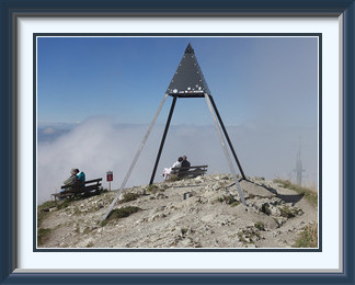
Beyond the farmhouse at Gros-Moléson, I was soon on a pretty woodland path running almost level across the southeastern slopes of the mountain. This continued for some time before a fork turned suddenly and steeply northwards towards the ridge between the Moléson and its neighbour, the Teysachaux. At last, I was sure I was heading the right way, and an hour later, I was standing on the summit of the Moléson with its lightning shelter. The summit area is a little disfigured by a tall telecoms tower built in recent years just below, but, given the Moléson's commanding position over the plains, the imposition is understandable.
As so often on this peak, rising cloud was partly obscuring the view. Much of the length of Lake Geneva should have been visible, as in this older photograph, but it wasn't this time. Visibility towards the Moléson's lower summit cross and the town of Bulle was much better. The big white cross in the picture marks the top of two difficult via ferrata ascents on the mountain's north face. To the east, twin peaks, the Dent de Brenleire and the even steeper Dent de Folliéran partly hid the snowy Bernese Oberland summits. Serried ridges, blue under the sun's glare, led to the Grand Muveran and the Dent de Morcles to the south. It was twenty years since I had ascended the latter.
The last fifty or so metres from the cable car station to the summit are moderately steep, so that most of the tourists are weeded out, and it was easy to get one of the seats by the lightning shelter to have my sandwiches in very pleasant conditions. Then I began the descent. With the signposts for the old way still in place, I chose it instead of the way I had come; there was unlikely to be much of a problem. The journey down was entirely familiar until near Plan Francey, when the path was blocked by a small rockfall. That must have been the reason for the diversion, but it was quite safe to cross and the rest of the walk was as in the old days.
Monte Gridone (also called Monte Limidario) is the tallest of the many peaks lining the shores of Lake Maggiore. It lies on the border with Italy west of the town of Brissago. Though not a particularly big mountain, its summit rises two kilometres above the lake, whose shores are the lowest point in Switzerland.
 The month was nearing its end; the week since the last walk had had a mixture of fine
and wet days north of the Alps, but conditions were better on the southern slopes. I was
due to take the wife and her sister for a few days' break in Locarno. There would most
likely be an opportunity there.
The month was nearing its end; the week since the last walk had had a mixture of fine
and wet days north of the Alps, but conditions were better on the southern slopes. I was
due to take the wife and her sister for a few days' break in Locarno. There would most
likely be an opportunity there.
Sure enough, the first full day of our stay was clear and mild. As soon as practicable after breakfast, I said goodbye to the ladies and set off along the lakeshore road toward Brissago, the last town before the border with Italy. After Ascona, the topography was the typical kind for the north Italian lakes. The highway was pressed tightly against Lake Maggiore by uniformly steep slopes, dotted by small hamlets at various heights up narrow, hairpinned side roads. The walk was to start from the roadhead at Cortaccio, one of those hamlets. I breezed through Brissago without seeing any signposts at any of the two or three junctions I passed, and had almost reached the Italian border post when I turned around. No problem, I thought, the GPS will provide the solution. The GPS did indeed give a route for Cortaccio, but a Cortaccio that was more than fifty kilometres away. My local map was too crude to be of help; I was on my own. The last of the side roads before the border looked to be the one I needed, so I would try it.
There ensued a harrowing hour creeping up and down steep, narrow roads, looking for a signpost, hoping not to encounter oncoming cars in the wrong places and making difficult U-turns in driveways and at road ends. After what seemed like an age of this somewhat dangerous driving, I was forced to give up and return to Brissago. For once, Murphy's Law failed and the local tourist office was open when I needed it. Asked how to get to Cortaccio, the girl at the desk was at first nonplussed, but then had a bright idea. There was a well-known restaurant on the road there, and it ought to be known to the GPS. Back at the car, I was relieved to see that it was, and soon I was driving past the Osteria Borei on my way to Cortaccio. The parking spot for visitors is a fairly rough spot in the woods more than a kilometre before the roadhead at the village itself. The burghers of Cortaccio have a fine and level parking area at their collective door, but they keep it to themselves with threats of towing; it was almost empty when I passed it.
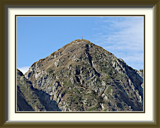
The signpost at the start of the walk included Monte Gridone and waypoints I expected to pass. That was very reassuring in an area I was not familiar with, but it was midday; I was seriously late, and it was no longer summer. I would need to focus on getting down before the light failed. No time to take photographs as I ascended the steep and at times rough Vantarone Valley before the track crossed easier ground to the Capanna Al Legn. This tiny hut has a peerless view over the upper lake from its terrace and must be a wonderful place to spend the night. Beyond the hut, the track ascended moderate grass slopes to a saddle called the Bocchetta di Valle, from which there was the first good view of Monte Gridone's summit. After the saddle, the track became steeper as it led up a stony couloir to reach the summit ridge. Conditions eased up on the ridge itself, a mixture of coarse grass and exposed rock, and soon I was looking at the big summit cross just above.
The summit was a pleasant enough place to eat a late lunch, but I didn't stay there as long as I would normally do. Nevertheless, there was time to take out the camera. Far off to the west, the Pennine Alps lined the horizon, including Monte Rosa, at 4634 metres the second highest peak in the Alps. The Gridone isn't a great viewpoint for the central parts of Lake Maggiore, as some subsidiary tops get in the way, but the southern end of the lake around Arona can be seen, along with the Appenine Chain across the northern Italian plains when the visibility is really good, which it wasn't on this occasion. Those who have taken the Centovalli tourist train from Domodossola in Italy to Locarno will likely remember the Gridone as the peak which towers over the line on the right as they enter Switzerland. The view from the summit down to the western end of the Centovalli and its hillside villages is correspondingly impressive.
The shadows were lengthening as I descended towards the Capanna Al Legn. With time becoming ever more of a concern, I had a chat with the hut guardian. Sure enough, a track heading straight down the slope offered a quicker way back to Cortaccio. Though steep, it was well enough marked and signposted that getting lost wasn't likely. A knee-testing descent took me first into scrub and then the woodland typical of the area. There was little of particular interest except for one lone, giant example of the cairn fairy's work in what seemed like a random spot in the woods. Not long after that I was back at the junction with the track I had used on the ascent. "Sentiero molto ripido" said the sign pointing back the way I had come, "very steep path", and it was fairly steep, though I didn't think it steep enough to merit a special warning. The sun was already gone at this stage, and in the remaining half-hour or so it took to get to the parking spot the light failed almost completely, so that I was only just able to see the car in the dusk. A close-run thing!