


The Männlichen is a mountain in the the canton of Bern at the fork of the White and Black Lütschine rivers, flowing down from Lauterbrunnen and Grindelwald respectively. Cable cars from both sides ensure that the summit area is busy in summer and winter. There are good views towards the high Oberland peaks.
 The walks in August having gone even better than those of July, the hope in September had
to be that the weather would play ball long enough for an effort to do at least some bigger
and more dif ficult walks
before going home. From this time on, an unlucky snowfall on the
heights could mean the end of the higher walks if the weakening sun failed to melt it fast
enough.
The walks in August having gone even better than those of July, the hope in September had
to be that the weather would play ball long enough for an effort to do at least some bigger
and more dif ficult walks
before going home. From this time on, an unlucky snowfall on the
heights could mean the end of the higher walks if the weakening sun failed to melt it fast
enough.
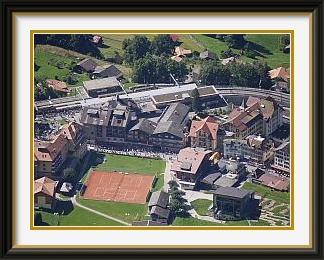
That was just how it was looking as I set out for the first walk of the month and the only one-way walk of the whole season, from the valley up to the finishing point of the Jungfrau Marathon, where an old friend was taking part. Fortunately for the runners, a couple of cool days with some heavy rain had finally replaced the summer heat. Having stayed overnight in his family's chalet near Interlaken (...always nice to stay in a place where you have this view from your bedroom in the morning), I caught the Grindelwald train to a handy starting point at Burglauenen station. From this insignificant hamlet, a somewhat unexciting track slants upwards along the forested slopes back in the direction from which the train has come, before rounding a corner into the main Lauterbrunnen Valley. Not long before the track reaches Wengen, at that moment full of marathon runners and onlookers, I turned off onto a track which ascended nearly a kilometre to the summit of the Männlichen in more or less continuous hairpins. On the last three hundred metres, as the track snaked between numerous avalanche barriers, traces of wet snow became more and more common. It augured badly for the rest of the season. Far below the summit, the runners made their agonising ascent towards the Wengneralp. The summit of the Männlichen is tourist territory, with lifts and restaurants nearby, and a more or less level footpath skirting the eastern slopes of the Tschuggen all the way to Kleine Scheidegg. This is one of the best places to see Grindelwald and its Wetterhorn backdrop. I was able almost to trot the four kilometres to Kleine Scheidegg, where the thousands of runners reached the finishing line to the accompaniment of a hideously loud broadcast commentary from loudspeakers lining the course. Of the journey down in the packed Wengneralpbahn train, the less said, the better. Standing room only, and some of the standing was by others on my toes.

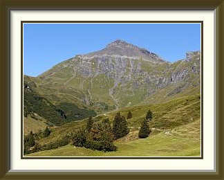
The Schilthorn is the highest ice-free mountain in the Lauterbrunnen and Grindelwald area before the main glaciated chain of the Bernese Oberland. As "Piz Gloria", it was the scene of a battle in the James Bond film "On Her Majesty's Secret Service". It can be reached by a long and expensive cable car ride from the Lauterbrunnen Valley, or by a correspondingly long (but not dif ficult) walk. The views are magnificent, the crowds less so.
 The threat of an early onset of autumn weather rapidly abated, so the door was open for a
longer walk, this time on familiar territory. I had been to the summit of the
Schilthorn a number of times over the years.
At just over 2100 M. from the starting point at the Schilthornbahn car
park, it's the biggest commonly done ascent in the Bernese Oberland. Despite the height,
it is frequented by crowds off the cable car in good weather,
and needs no more than a T2 rating. On arrival this time,
I noticed that they were now charging for car parking. This trend has been progressing in
Switzerland in recent years, presumably to force at least some income out of
visitors who don't use the (expensive) facilities.
The threat of an early onset of autumn weather rapidly abated, so the door was open for a
longer walk, this time on familiar territory. I had been to the summit of the
Schilthorn a number of times over the years.
At just over 2100 M. from the starting point at the Schilthornbahn car
park, it's the biggest commonly done ascent in the Bernese Oberland. Despite the height,
it is frequented by crowds off the cable car in good weather,
and needs no more than a T2 rating. On arrival this time,
I noticed that they were now charging for car parking. This trend has been progressing in
Switzerland in recent years, presumably to force at least some income out of
visitors who don't use the (expensive) facilities.
The early ascent is in the shadow of the big Oberland peaks until the last chalets above Gimmeln catch the first rays below the Eiger and Mönch. The trail continues along the high pastures of the Schilt Valley before a long and somewhat steep ascent up grassy slopes to the little Grauseeli lake and the final stretch over barren rocks to the summit. I checked my watch... four hours and thirty minutes from the car park, exactly half an hour longer than it took me when I first did the same walk, thirty-two years almost to the day earlier. No lonely eyrie this, with hordes of tourists ferried up on the long cable car run via Gimmelwald, Mürren and the Birg, some of the more active ones venturing off the observation terraces for the view down to the upper Kiental. A Bollywood crew was filming some fatheaded takes; with temperatures around 5°C, the actress didn't stay dressed like that for long. The Büttlassen was not far away, the recent snow having probably closed it to walkers for the rest of the year.
I had passed cattle being herded down from their summer pastures as I ascended, and now, on the way down, I watched Mountainy Man dismantling fences while the sun still shone. In the clear September light, the high peaks remained splendidly visible until the path finally descended into the shadowy Lauterbrunnen Valley once more.
The Stockhorn is a peak at the northern edge of the Prealps in the canton of Bern. Its sheer northern face is prominently visible from the nearby town of Thun. It can be climbed most easily from Erlenbach village in the Emmental, from where a cable car runs to the restaurant just below the summit.
 By mid September, dull and calm weather had set in, with high-altitude cloud above a motionless
layer of greasy murk on the plains.
A familiar but longer walk was indicated, so I chose to do an afternoon trip up the Stockhorn,
this time via the "tourist route" from the Simmental. I parked in the big park
opposite the cable car station in Erlenbach (free here!), and sped up the steep village streets
towards the start of the path.
By mid September, dull and calm weather had set in, with high-altitude cloud above a motionless
layer of greasy murk on the plains.
A familiar but longer walk was indicated, so I chose to do an afternoon trip up the Stockhorn,
this time via the "tourist route" from the Simmental. I parked in the big park
opposite the cable car station in Erlenbach (free here!), and sped up the steep village streets
towards the start of the path.
Passing a school where classes had ended and kids were heading off in all directions. I suddenly noticed that one, a boy of eight or nine, was speaking to me... something about Dad often not driving down to pick him up, so he would accompany me up to his house up the hill if I didn't mind. Er, was the house near the path to the Stockhorn (my Schwyzerdüütsch extends just far enough to talk to children)? I didn't want to have to make a big detour if not. Oh yes, close by! So off we set for twenty minutes of quite pleasant conversation about school, the names of the surrounding hills and so on until, some two hundred metres higher, the house was indeed visible a little off the trail, with Dad in the garden. "What's your name?", I asked as we parted. "Caroline"... the perky boy-cut hair had had me fooled. I thought sadly as I continued upwards that such an encounter would probably not be possible any more in New Zealand or Britain, where the precautionary approach towards protecting children now transcends all sense.
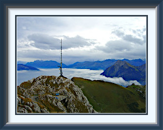
Between the murk below and the high cloud, the view from the summit over the plains was clear enough. Interlaken and the lakes were completely hidden and the views in other directions were too leaden for ordinary photographs to be interesting, so I turned the camera's artistic functions on for a posterised shot of the Stockhorn's telecoms tower and another of the Hinterstockensee and the trail down to Erlenbach. Weak rain towards Grindelwald never reached the peak as I sped back down through the dullness. A season's exercise was clearly showing results, with the whole walk, including looking after kids and forty minutes' rest at the summit, taking only a hair over the signposted time for the ascent.
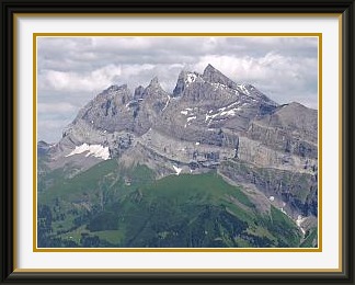
The Dents du Midi are the seven summits of a massif in the Chablais Alps in the canton of Valais. The easternmost summit overlooks the nearby Rhône river more than 2700 metres below, but only the highest summit, the Haute Cime at the other end, is walkable. The relatively isolated massif is a favourite postcard subject, often as a backdrop for Château Chillon on the shores of Lake Geneva.
 The stay in Europe was drawing to an end and the indifferent weather continued, frequently dull, with
occasional drizzle and no longer warm. Crucially, however, there were no stormy intervals and no real
cold yet. This meant that conditions on the high peaks were still likely to be good,
especially on southern aspects. So for the final act of the season I settled on the
Dents du Midi, whose multiple summits loom above
the Rhône Valley in an area where the climate is slightly milder than that of the Bernese Oberland.
As the "Haute Cime", the highest summit and the only one accessible to walkers,
is well above 3000 metres, I rang the the hut at
its foot the day before to check conditions before setting out on an
expedition which would involve more than 300 Km. of driving on top of everything else. No problem at
all, said the patronne of the Cabane de Susanfe. No snow, no ice. Yay!
The stay in Europe was drawing to an end and the indifferent weather continued, frequently dull, with
occasional drizzle and no longer warm. Crucially, however, there were no stormy intervals and no real
cold yet. This meant that conditions on the high peaks were still likely to be good,
especially on southern aspects. So for the final act of the season I settled on the
Dents du Midi, whose multiple summits loom above
the Rhône Valley in an area where the climate is slightly milder than that of the Bernese Oberland.
As the "Haute Cime", the highest summit and the only one accessible to walkers,
is well above 3000 metres, I rang the the hut at
its foot the day before to check conditions before setting out on an
expedition which would involve more than 300 Km. of driving on top of everything else. No problem at
all, said the patronne of the Cabane de Susanfe. No snow, no ice. Yay!
I was on the way from Burgdorf at five thirty the next morning to set out from Champéry as the sun rose. The first thousand metres of ascent take one through the woods above the town and the Pas D'Encel with its secured passages on a cliff leading into the enclosed, grassy Susanfe Valley where the hut lies. Beyond the hut, the Haute Cime comes into view as the grass fades away on the approach to the Col de Susanfe, where the unmarked summit track begins. On the way up, there are views of the other Dents and the little Plan Nevé glacier. If the scree is already bad above the Col, it becomes truly horrendous after the Col des Paresseux (where lazy walkers are said to give up), and it was at times quite dif ficult to identify the "path" at all. On top, at last, the tilted strata made it something of a struggle to find a comfortable resting place. The summit would in any case be a great viewpoint, but its isolation makes it exceptional. Down the north face, the whole of the Val d'Illiez is visible, including Champéry. The views into France are particularly good, including the Dru and the Dent du Géant and the Aiguille du Midi téléphérique station silhouetted against the snows of Mont Blanc. The hour spent alone on the summit was a time of exceptional quality in a day in which everything went right.
Back down in greener surroundings after the last, best walk of the season, I could be thankful for a year when the weather never seriously interfered with my plans. I broke the return journey for dinner in Montreux and was home by midnight.
Two days later, I was on the plane to New Zealand. That's the way to do it!