


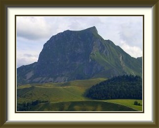
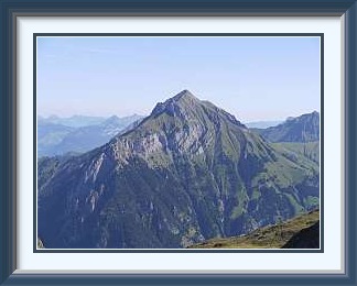
The Gantrisch is a mountain at the edge of the north-western Bernese Alps, overlooking the Aare River Valley and the flatter country to the north around Bern. It is a popular ascent from the Gurnigel Pass.
 Just two days after flying in from New Zealand, I attempted to shake
off the jet lag by doing my favourite quick and easy walk, the
Gantrisch. Hard to say what ascent this was
going to be, number 50, number 75...? I haven't kept records well enough
over the years. From the plains, it's just a quick drive over the Gurnigel Pass
(1584 M.) and down a little again to a handy parking spot at the foot of the
peak.
Just two days after flying in from New Zealand, I attempted to shake
off the jet lag by doing my favourite quick and easy walk, the
Gantrisch. Hard to say what ascent this was
going to be, number 50, number 75...? I haven't kept records well enough
over the years. From the plains, it's just a quick drive over the Gurnigel Pass
(1584 M.) and down a little again to a handy parking spot at the foot of the
peak.
Seen from the road, the peak looks quite a bit more impressive than it really is. The initial slog is up a jeep track, before the mountain path proper leads to the little Morgetepass, where it turns sharply to the east. After passing an abandoned military pillbox, the track heads up steepening grass slopes before a short and easy scrambling section brings you out onto the surprisingly large meadow on top. A dark-roofed mountain restaurant can be seen in the upper centre of this view from the summit; the car park visible just to its right is where the walk began. The jeep track can be seen running down towards the lower left. It's less than 700 M. from there to the top, but the walk is greatly enhanced by the way the track doubles back on itself, so that you look precipitously down on your starting point. There were already a few people at the summit; it's uncommon to be alone there unless the weather is really poor or you go at an odd hour.
This wasn't the only time in 2009 I ascended this most familiar of summits. When I had built up some fitness, the whole trip could be done in less than two hours from the road, a time short enough to obviate the need for rucksack, food or drink. As the season advances, it provides an enjoyable way to get above the layer of stratus which often covers the plains, and it is then a great place for people to photograph one another above the clouds.

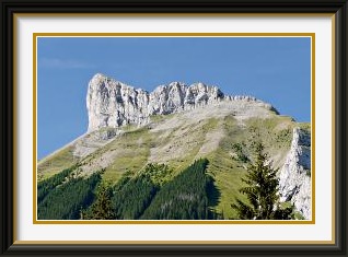
The Schibengütsch is a mountain in the Prealps in the canton of Lucerne. It forms the southwestern end of the karst limestone ridge called the Schrattenflue. It is most easily approached from Kemmeribodenbad in the adjacent canton of Bern.
 I was putting some emphasis on filling in local peaks I hadn't done before,
so the next choice was something called the
Schibengütsch, lying to
the north of Lake Brienz and looking down on the Emmental. The public road ended
with a fine new covered bridge,
not yet officially opened, across the very young but flood-prone Emme at Kemmeribodenbad,
where I parked the car and set off up through sunny woodlands and alpine meadows.
I was putting some emphasis on filling in local peaks I hadn't done before,
so the next choice was something called the
Schibengütsch, lying to
the north of Lake Brienz and looking down on the Emmental. The public road ended
with a fine new covered bridge,
not yet officially opened, across the very young but flood-prone Emme at Kemmeribodenbad,
where I parked the car and set off up through sunny woodlands and alpine meadows.
It's rare that a new walk has nothing unexpected, but this one had a major surprise. It negotiates a cliff using an abandoned military emplacement dug into the rock; with nobody else around, I had to climb its vertical exit shaft in pitch darkness. All you can do in these circumstances is take it really slowly. I've only come across this once before in the Swiss Alps. In that case, it was a stretch of natural cave, and if somebody coming out as we arrived hadn't given us his disposable flashlight, we would have had to turn around. Not far from the summit, a wonderful opportunity for boulder trundling presents itself1. However, it's not reachable by walkers, even those with very powerful boots. On top at last, there is a fine view along the ridge as far as the Hengst. You can see your car park here too, but in this case the height difference is more than a thousand metres.
Back in Kemmeribodenbad, you can reward yourself for a successful walk with a meringue if you like them, as the restaurant beside the car park is said to have the best for miles around.
The Col de Cou is a non-motorable pass on the French-Swiss border south of Lake Geneva. It links Morzine in the French department of Haute-Savoie and Champéry in Switzerland.
 This walk was the only one I did with company this year. The name seems to be popular;
there is a somewhat higher pass of the same name south of Sierre,
and another motorable one south of Thônon-les-Bains in France.
I collected a Walking Friend of long standing who lives near Montreux, and we drove
to Champéry in the Val d'Illiez on the Swiss side of the French border south
of Lake Geneva.
This walk was the only one I did with company this year. The name seems to be popular;
there is a somewhat higher pass of the same name south of Sierre,
and another motorable one south of Thônon-les-Bains in France.
I collected a Walking Friend of long standing who lives near Montreux, and we drove
to Champéry in the Val d'Illiez on the Swiss side of the French border south
of Lake Geneva.
Though we had done some quite serious stuff in the past, the WF wasn't feeling fit, so this time it was just an easy path climbing about 900 M. from Champéry to a pass called the Col de Cou. There was a border post at the pass, half hidden by a knoll in the picture, but it was unstaffed. Not surprising really, as Switzerland had joined the Schengen Area just a year earlier. A tempting track led southwards towards the Dents Blanches, but time and condition were lacking. Having not yet exhausted our energies, we followed a path upwards along the border for a while, but it petered out in the middle of a very steep grassy slope which dropped off vertically into Switzerland just to the right of us. Things were getting T4ish, with little to hold onto in case of a slip, so we turned back at around 2130 M, there being no tempting destination in view anyway. Path traces can be seen in the last picture, but they may just have been worn by chamois or ibex.
The Hohgant massif in the canton of Bern lies between Lake Brienz to the south and the upper Emme Valley to the north, which it overlooks prominently. Its highest summit is the Furggengütsch.
 A few days later, it was the turn of the Furggengütsch,
the highest summit of the Hohgant Massif.
This was an easy option in one sense, because although I hadn't done this peak before
either, all I had to do was drive to the same parking place as for the
Schibengütsch
to walk it; it lies on the other side of the same valley.
A few days later, it was the turn of the Furggengütsch,
the highest summit of the Hohgant Massif.
This was an easy option in one sense, because although I hadn't done this peak before
either, all I had to do was drive to the same parking place as for the
Schibengütsch
to walk it; it lies on the other side of the same valley.
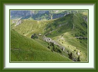
After a short walk up a closed road, the track took on a more alpine aspect above Schärpfenberg as it traversed the southern slopes of the Hohgant massif. Just below the tree limit, the Hohgant Hut lay silent and closed in the warm sunshine. This hut has no warden and needs to be reserved in advance, when they give you a code to open the lock on the door. Not unreasonable, with supplies of wine and beer maintained inside for the pampered overnight walker!
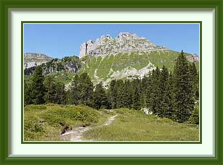
The summit has a clear view across the Bumbach Valley to the aforementioned Schibengütsch and the ridge stretching away to the Hengst on the left. As it's at the northern limit of the proper mountains, there's a great view over the Emmental countryside. You also get a fine panorama of the Bernese Oberland peaks, from the Schreckhorn on the left to the Jungfrau on the right. At places like this, you notice that some summits are affected by a craze for cairn building; there were quite a few apart from the one in the picture.
The Dreispitz mountain in the canton of Bern lies to the south of Lake Thun and to the east of Frutigen in the Kander Valley. It overlooks the Kien Valley and can be climbed from Kiental village or from the Suld Valley to the north.
 Time for something a little harder now. The ascents so far were no more than 1200 M, so
how about something nearer 1600? I had always wondered why the
Dreispitz
had no path marked on the walkers' maps, even though it is a prominent peak quite close to
Lake Thun. Well, on the upper stretches it's marked as a blue
route, which means it's considered harder than regular mountain paths, though in this
case not by much.
Time for something a little harder now. The ascents so far were no more than 1200 M, so
how about something nearer 1600? I had always wondered why the
Dreispitz
had no path marked on the walkers' maps, even though it is a prominent peak quite close to
Lake Thun. Well, on the upper stretches it's marked as a blue
route, which means it's considered harder than regular mountain paths, though in this
case not by much.
After the long ascent from Kiental Village to the saddle called the Renggpass, the track goes up the left-hand skyline in the picture, and it's not too bad, with some interesting side excursions (note the walker at upper right). The summit had a cross needing refurbishment and a great view over Lake Thun to the distant Jura mountains on the horizon. Oddly, there were clouds of flies on top, even though the summit is surrounded by bare scree and is a couple of hundred metres above anywhere farm animals would be likely to reach. The question is... what do they feed on when my sandwiches aren't there?
As I watched from the summit, some walkers tried to descend via the lovely ridge to the northeast. However, the little summit where the ridge turns hides a razor-sharp ridge on the other side with near-vertical towers. As the whole is of rotten and crumbling slate, the journey further is not just very difficult, but objectively dangerous. After peering over the edge for a while, they turned back.
The peak must be just about the best possible place for a view of the Blümlisalp Range, none of whose summits are walking territory, although there are many beautiful paths which approach them.
Notes:
- Boulder trundling can be an amusing diversion, but don't do it unless you can see the whole runout below. If it or its fragments disappear over a cliff, who is to know what harm might be caused to people or property? ↑