


The Bella Tola is a mountain in the Pennine Alps south of the Rhône Valley, lying between the side valleys Val d'Anniviers and Turtmanntal. An easy path up its southwest side leads to a summit which, while not particularly close to any major peaks, commands a panoramic view of almost the whole of the Bernese Oberland as well as the major Pennine tops.
 Punctually on the last day of August, the summer weather had ended with rain moving in. The
first day of September was coldish and rainy, and there had been snow to about 2000 metres
in much of central and eastern Switzerland. The Valais had so far escaped; a look at a few
webcams showed that there was little or no snow below 3000 metres. So... it would be
possible to find a peak that height, but wisest to pick an easy one in case the snow
decided to head west. There are few easier than the Bella Tola.
Punctually on the last day of August, the summer weather had ended with rain moving in. The
first day of September was coldish and rainy, and there had been snow to about 2000 metres
in much of central and eastern Switzerland. The Valais had so far escaped; a look at a few
webcams showed that there was little or no snow below 3000 metres. So... it would be
possible to find a peak that height, but wisest to pick an easy one in case the snow
decided to head west. There are few easier than the Bella Tola.
Once more I was up early, off well before seven down the Autobahn to Montreux to collect the Walking Friend, then back onto the Autobahn to Sierre in the Rhône Valley. Here, the main road climbed steeply up the Val d'Anniviers before a much narrower road zigzagged up to St-Luc, where the walk started. My attempts to memorise the layout of this alpine village turned out to be of little use because the road through the centre was closed to vehicular traffic, and we lost time circling below the town to reach a parking place close to the funicular station, where online maps indicated that a path began. Unfortunately, nothing like a marked path existed nearby. Enquiries by the WF at the ticket office secured us a map of the resort, but of the drawn-by-a-child variety popular only in the French areas. Nevertheless, a short walk to St-Luc's central square found us a signpost, and we were off. Instead of heading up the hill, however, this track, at times a road, led at a gentle slant so far northwards that we were on the point of giving up, when finally a more serious path forked left in the direction I was hoping for to the upper station of the funicular at Tignousa. The next waypoint, the Cabane Bella Tola lay directly above, but once more, the signposted route headed off northwards, barely climbing at all, until after some time a dogleg took us at last more directly to the Cabane.
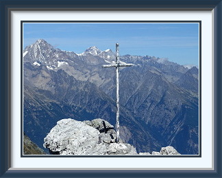
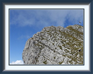
Beyond the Cabane, we were on less frustrating terrain, and soon we had a good view of the Rothorn and the ridge to the Bella Tola. After a while on a mixture of paths and jeep tracks (this being primarily a ski area), a steeper track turned left and ascended in hairpins to the ridge. Soon afterwards, we were looking at the final approach to the summit. The weather had stayed friendly, but a keen, cold breeze on top meant that I had to don a fleece jacket fairly quickly. The summit consisted of a short level stretch of boulders, at whose northeastern end a lackluster cross confronted a fine view of the western Bernese Oberland across the Rhône Valley. To the northwest along the aforementioned ridge on an easy track, the Rothorn had a covered belvedere to offer visitors, and to the south, one of the giants of the Swiss Alps, the Weisshorn towered over the Brunegghorn and the Barrhorn.
As we were enjoying the splendid views, a voice called up to us "Are you at the summit?", and we were happy to confirm that we were. Two Swiss walkers had come up by another, steeper path, and were soon beside us, whereupon we fell into conversation with Eric and Daniel Zangger. So far, so normal, until Daniel mentioned that Eric, his father, was 91! A stunning reminder that if you can keep your health, it is the case for mountain walking, unlike so many sporting activities, that you need almost never retire.
Buoyed by the thought that we probably had a few more years left in us, we headed back off the summit ridge and down the hairpins to the grassy terrace called the Roua with its backdrop of the high Valaisian peaks. From the Cabane, we could see the Tignousa funicular terminus directly below, so we went straight down to it on unmarked tracks, and it was here, reading the maps and diagrams on the wall of the station, that the penny dropped. The reason why we couldn't find a way directly up the hill from St-Luc was that the paths had been hijacked for mountain biking. Being unwilling to use the funicular, and there being no mountain bikers around, we set off down what had once been "our" path, but the U-shaped cross-section and the jumps constructed on the way made it an uncomfortable experience, and we used open clearings, bits of jeep track and service roads wherever we could. Back at the empty off-season car park, I decided that St-Luc was probably not the best place for those who want to walk the whole mountain.

The Nollenhorn is a mountain in the Pennine Alps at the head of the Saas Valley east of the Mattmark Reservoir. Unusually for a peak of no great dif ficulty, after a short and faintly-marked track off the main Ofental path, there are no paths to the summit. It is up to the walker to select a route. In poor visibility this a dangerous mountain for the inexperienced, as descending too directly leads to vertical drops onto the reservoir service road.
 It had been more than a week since the last walk, a week without settled
weather while a kink in the jetstream over Switzerland kept cold high-altitude
air over the country. As a result, snow was still falling as low as about 2000
metres on the northern side of the Alps. I would have to head south again. Time
and the cold conditions meant that camping wasn't an option, so it would be another
day trip. The Saas area would do; the road up was faster than many in the Pennine
Alps, and there was one more peak I knew should be doable, the Nollenhorn.
It had been more than a week since the last walk, a week without settled
weather while a kink in the jetstream over Switzerland kept cold high-altitude
air over the country. As a result, snow was still falling as low as about 2000
metres on the northern side of the Alps. I would have to head south again. Time
and the cold conditions meant that camping wasn't an option, so it would be another
day trip. The Saas area would do; the road up was faster than many in the Pennine
Alps, and there was one more peak I knew should be doable, the Nollenhorn.
After the usual early start and ride across the Lötschberg, I was once more parked at the Mattmark dam. On the same southward path along the side of the reservoir I had used to reach the Jazzihorn more than three weeks ago, conditions were unchanged, except that fresh snow had dusted the peaks along the Italian border. Twenty minutes or so along the track up into the Ofental, a couple of casual cairns were the only indication that a weakly-defined track led back northwards along the grassy slopes high above the way I had come. Eventually, a much more conspicuous cairn marked the point where the little path petered out, and I reckoned that this was the place to start aiming for the peak.
There followed a long session up stretches of boulder-filled grass. The scraps of disconnected path were so short that they had to have been made by wildlife, and the few random cairns provided no obvious guide to the way ahead. Whenever the grass ran out, it was always possible to traverse a neighbouring rockslide and find more. In this way, I ascended the Wysstal until I crossed a shallow, stonier saddle into the Rottal, where more thinning grass and boulders led up to a narrow terrace of mud and grass. With the entire ascent from the conspicuous cairn unmarked, both in the LK and on the ground, I had no exact idea where I was. The summit ridge stretched in front of me, its steepest part to the left; no doubt the summit was up there somewhere. Unfortunately, the ridge lay across a sea of boulders, and a test walk into them showed that I would not reach it in any reasonable time. To the right, a field of smaller boulders led to a slope of reddish grit below a saddle. Just to the left of the saddle was a small knoll on the skyline; with the summit apparently off the menu, it would serve as a consolation prize.
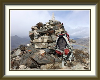
It was the work of a few minutes to cross the boulder field and climb the muddy grit to the crest. A few minutes more took me to the top of the knoll, where the summit ridge stretched off to the north... downwards. I was on the summit after all! As well as the orange lichen visible in the photograph, there were also clumps of green moss between the rocks and small tufts of grass, complete with seedheads, possibly carried up this height by walkers. The cairn fairy had done a decent job, but there was no cross, no summit book nor anything else. The 4000ers around Saas-Fee were all hidden behind a veil of fine snowfall, but there was a good view across the saddle to the south as far as the Stellihorn, looking rather different from how it had looked from the Jazzihorn.
Not long into the descent, cloud descended and the featureless, trackless slopes disappeared into the mist. The sound of the streams draining the Allalin Glacier on the other side of the reservoir served as a crude compass, but only the careful memorisation of some rock steps and boulder piles on the way up enabled me to find the saddle across to the Wysstal and the rest of the descent. Beneath the cloud at last, it was not long before I could make out the conspicuous cairn below and the start of the path back to the car.
The Hengst is one of the summits of the ridge called the Schrattenflue in the Emmental Alps at the southernmost extreme of Canton Lucerne. The eastern slopes of the Schrattenflue have the most extensive fields of exposed karst limestone in the area, requiring care when crossing them to reach the tops from the Sörenberg Road.
 The unsettled, coldish weather dragged on; in the lowlands the typical temperature
range for September is 16 to 24°, but for some time now it had been 13 to 16°
instead. Early mornings in town were not much above freezing on some days, a minor
nuisance there, but a bigger one in the mountains. With the zero-degree level hovering
around 2000 metres, every shower left a thin layer of snow on peaks even below that
level. The snow didn't survive much sunshine, but its gentle melting left behind
sodden, muddy tracks. One solution to the problem was, of course, to choose a peak
consisting of as little soil as possible. There were not many such nearby, but I had
been on the Schrattenflue many years ago, and I remembered its vast areas of bare
karst limestone. It reaches its highest point at two peaks, the Hächle and the
Hengst. The latter was more accessible.
The unsettled, coldish weather dragged on; in the lowlands the typical temperature
range for September is 16 to 24°, but for some time now it had been 13 to 16°
instead. Early mornings in town were not much above freezing on some days, a minor
nuisance there, but a bigger one in the mountains. With the zero-degree level hovering
around 2000 metres, every shower left a thin layer of snow on peaks even below that
level. The snow didn't survive much sunshine, but its gentle melting left behind
sodden, muddy tracks. One solution to the problem was, of course, to choose a peak
consisting of as little soil as possible. There were not many such nearby, but I had
been on the Schrattenflue many years ago, and I remembered its vast areas of bare
karst limestone. It reaches its highest point at two peaks, the Hächle and the
Hengst. The latter was more accessible.
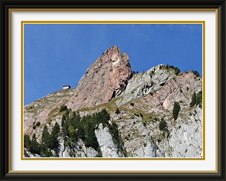
Off the road to Sörenberg, an easy mountain road became unsurfaced before it took me to Alp Schlund, where a small parking area behind the farm buildings wasn't explicitly marked as private, though it almost certainly was. In any case, nobody came to object. Not far into the belt of forest above the Alp, the first fingers of limestone seemed to bubble out of the ground, as if under pressure. The trees were soon left behind, and the well-marked path entered a full-blown karst landscape. In places, the route was a random walk through an endless variety of fixed and loose boulders of all sizes, but elsewhere some of the bigger channels provided a natural course for a path. In its most extreme manifestations, the erosion reduces the solid limestone to a sort of demented jigsaw. Not the sort of place to have a fall!
Emerging above the karst into somewhat greener surroundings, I could at last see the Hengst and the smaller tops along which the path would go. To the left of these, the ascent up grass to the saddle had the only real mud of the day, and in no time my boots were heavy with the stuff. Conditions were grey on the summit, and it was soon enveloped in mist. There was the expected summit cross as well as a neat freestanding summit book holder, complete with fresh book inside.
Not three minutes into the descent, the clouds suddenly cleared, and I looked back to see the summit in sunshine. In the improved conditions, there was a decent view of the Hengst's sister summit, the Hächle, and conditions remained friendly all the way back to Alp Schlund and the car.
The Gross Mythen and the Klein Mythen are a pair of distinctive free-standing peaks in the Schwyz Alps prominently visible from many locations around the lakes of Zug and Lucerne. The short but steep ascent from the saddle at Holzegg leads to a serviced mountain hut with splendid views. Despite its small size, the mountain is a Swiss icon, depicted on their first set of postage stamps to show landscapes, issued in 1914.
 Three weeks of cool and fickle weather were coming to an end. So, unfortunately, was
our stay in Switzerland; a single fine day was forecast before we would have to
start packing. The Old Work Colleague had been expressing an
interest in an outing, as well as another colleague from the old days, a
lady more usually occupied with golf who had only recently taken up hillwalking.
The Golfing Lady would welcome the chance to try something a little harder than
she was used to.
Three weeks of cool and fickle weather were coming to an end. So, unfortunately, was
our stay in Switzerland; a single fine day was forecast before we would have to
start packing. The Old Work Colleague had been expressing an
interest in an outing, as well as another colleague from the old days, a
lady more usually occupied with golf who had only recently taken up hillwalking.
The Golfing Lady would welcome the chance to try something a little harder than
she was used to.
Out of the limited list of mildly challenging summits nearby that none of us had done, I had been thinking of the Dent de Savigny near Bulle. However, the melting autumn snow and likely wet and silty rock surfaces (cf. its near neighbour, the Dent de Brenleire) were enough of a safety risk to make it inadvisable. In the same area, the Moléson presented no such risk, but we had all done it before. The last peak I could suggest was the Gross Mythen, but it was about 150 kilometres away in the other direction, and I had an unmissable dinner appointment that evening. To allow a decent safety margin, we would have to set out from Burgdorf at half past six, well before dawn. Were they up for it? They were.
Came the day, and the OWC and the GL arrived at the car park exactly on time. The journey to the town of Schwyz along four different motorways went without delays, but then something unexpected happened. The starting point for the the walk lay near Mythenbad, a hamlet at the end of a tiny road high above the town. But there were many such hamlets along various tiny roads, and there were no signposts for Mythenbad; indeed, there were very few signposts at all. Pressed into service, the GPS did the electronic equivalent of shrugging its shoulders. We spent an age on nerve-wrackingly narrow and steep lanes before one we had initially dismissed as unlikely turned out to be the right one, and we found the row of eight parking spaces and the walk signpost I knew existed.
The first five hundred metres of the ascent ran up through undistinguished grassy slopes and patches of forest as far as the Holzegg Saddle. There the Gross Mythen burst into view, no Everest at only another five hundred metres above us, but splendidly steep nonetheless. The saddle is served by a cable car from Brunni Village below, rendering access from the Zürich area easy, and the elaborate warning sign at the base of the peak was a hint that things might not be as quiet as I had been expecting. As the path gained height rapidly, the view down to the Holzegg became ever more precipitous. Many of the steeper stretches appeared to have been blasted out of the mountain with dynamite, and nearer the top, some parts were pleasantly airy.
The Mythen's summit cross stood on a boulder requiring a little clambering to reach it; few were deterred. On a peak as steep and well set off as this, the boulder and the terraces around it naturally offered magnificent views in every direction. To the north, the Alptal stretched off to distant Einsiedeln. To the west, small towns peppered the landscape around the little Lauerzersee. The Alps filled half the horizon from the Bernese Oberland giants at an unfamiliar angle in the west to the Glärnisch and beyond in the east. And when every peak had been identified, and every lake and every town below, those who had not brought their own sustenance could dine at the summit restaurant while drinking in the view.
The early start meant that we were able to leave the summit at midday, and the journey down was unremarkable except for the number of people on the path, now obviously in its busy hours. We were back at the car at two o'clock, early enough to beat the traffic jams and drop the OWC and the GL off at their car barely two hours later after a walk which, though not a heroic end to the season, was nonetheless a very pleasant one.