


The Hochstollen is a mountain in the Uri Alps. It can be approached from Wasserwendi to the east of the Brünig Pass in Canton Bern. Its summit lies just across the border in Canton Obwalden, and can be reached more directly from Melchsee-Frutt in that canton.
 With a planned holiday to the British Isles eating up the last week of
July and the first two of August, the year's walking had to start earlier
than usual to get enough done in the month. Something reasonably high was
desirable to escape the early July heat. At the same time, I needed a
starting point which wasn't too low, to keep the total ascent manageable;
it would be the first walk of the season after all. The choice went
to the Hochstollen, east of the Brünig Pass. To reach it, it was going to
be necessary to drive the the whole length of Lake Thun and Lake Brienz,
then up the pass and along narrow roads eastwards.
A drive of nearly two hours, but just about everything
nearer of a similar standard had been done long ago. As it happened,
the Congenial Swiss Lady was available at short notice, so it was the
work of a few minutes to leave the Autobahn and pick her up.
With a planned holiday to the British Isles eating up the last week of
July and the first two of August, the year's walking had to start earlier
than usual to get enough done in the month. Something reasonably high was
desirable to escape the early July heat. At the same time, I needed a
starting point which wasn't too low, to keep the total ascent manageable;
it would be the first walk of the season after all. The choice went
to the Hochstollen, east of the Brünig Pass. To reach it, it was going to
be necessary to drive the the whole length of Lake Thun and Lake Brienz,
then up the pass and along narrow roads eastwards.
A drive of nearly two hours, but just about everything
nearer of a similar standard had been done long ago. As it happened,
the Congenial Swiss Lady was available at short notice, so it was the
work of a few minutes to leave the Autobahn and pick her up.
The little road from the Brünig Pass grew steadily narrower and just after Hasliberg Wasserwendi ceased to be open to the general public. We parked in the grounds of a tourist chalet which was fairly clearly closed for the summer and headed up the rest of the road on foot. A couple of kilometres of asphalt brought us to Bidmi, where we were able at last to use a signposted Wanderweg. This led us up through the alpine forests with such a generous helping of space on both sides that we were obviously using the winter ski runs. Sure enough, the next waypoint at Käserstatt had a substantial lift, beyond which the path ran prettily through summer pastures. After this there were no more trees.
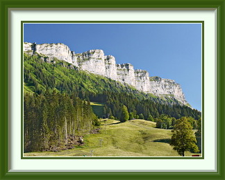
An uninspiring stretch up grassy slopes marred by another ski lift led to the first view of the peak. There were more green slopes before the path finally executed a wide curve towards the NW to reach a saddle called the Wit Ris, where the Hochstollen's much steeper eastern face was revealed. Here was a good example of how a mountain like this is laid down in a thousand layers over the aeons. Just at this spot, the path left Canton Bern. Barely inside Canton Obwalden, the same layers are exposed in a thin vertical slice; how many years remain before some critical stone erodes and the whole lot crashes down into the valley?
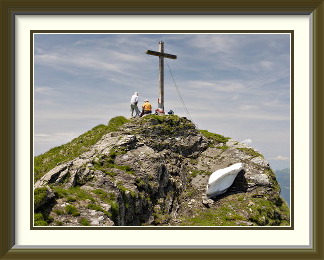
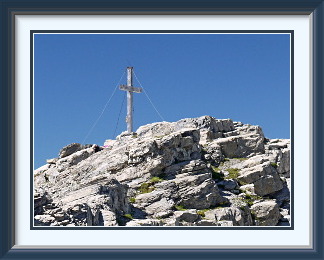
Not far beyond this spectacle, the rough stretch of the path ended and it broke out onto gentle grass slopes around the summit. There was the usual summit cross along with a few sculpted remnants of winter snow, still holding out against the early summer sun. Apart from the familiar views of the Bernese Oberland, there are fine views of mountain scenery in all directions, including that of the glaciated Titlis beyond the tourist spa of Melchsee-Frutt. Against appearances, the top lake in the photo is the lowest, not the highest, of the three; it alone lies in the Engstlen Valley, which drains off to the right of the picture.
After the customary hour or so in the sunshine, we headed off down the mildly interesting rocky part of the mountain's south ridge before tackling all that grass again.

The Sieben Hengste (Seven Stallions) are a line of Karst tops in the Emmental Alps south of the Eriz Valley. Paths approach them from the east and the west, but there is no defined track across the bare, furrowed limestone on the summits. The traverse is nevertheless not particularly dif ficult, though care is needed around various sinkholes and sharp limestone edges.
 More than a week had passed since the first walk of the year, occasioned by
a typical bout of bad summer weather for Switzerland. Three days after that
walk, a burst of lightning and hailstones heralded the end of the fine
weather as a cold front moved in from the Atlantic, and temperatures sank
until there were days where they barely reached twelve degrees and fresh snow
could be seen below 2000 metres in the Alps.
More than a week had passed since the first walk of the year, occasioned by
a typical bout of bad summer weather for Switzerland. Three days after that
walk, a burst of lightning and hailstones heralded the end of the fine
weather as a cold front moved in from the Atlantic, and temperatures sank
until there were days where they barely reached twelve degrees and fresh snow
could be seen below 2000 metres in the Alps.
When sunshine once more had the upper hand, it was time to choose a hill that wasn't too high while the fresh snow further up melted. One of the very few such left within a short driving distance was the strikingly even line of tops known as the Sieben Hengste (the Seven Stallions). Though none reached even 2000 metres, this area was one of only a few places in the Bernese Alps having karst fields, with their often weirdly eroded curves and gullies.
So it was that I parked the car at the end of the narrow road to Innereriz and headed up the popular track towards the curiously shaped saddle called the Sichel, with the towers of the Sieben Hengste still in morning shadow. At the Sichel, I turned up steep ground towards the sheer cliffs of the Schibe, the nearest of the Sieben Hengste, and left behind the busy world of the walkers going between Innereriz and Lake Thun via the Justistal. The path became more interesting as it skirted the Schibe, before ascending a rocky gully to the grassy top. On the way up I met three more walkers, the last I was to see all day, and the gully was the last place where there was any well-defined path.
The Schibe was a good place to stop for a lunch snack and enjoy another fine view of the Bernese Oberland. From here, the successive tops stretched off to the northeast, and each one offered a different view of vertical rock and distant Innereriz below. You could pick your own route across the main karst field, but care was necessary, for the whole area was riddled with holes, and this type of erosion can leave very sharp edges.
On the easternmost of the prominent tops stood a single large cairn, the only one, and indeed the only waymark of any kind since the Sichel. Descending at last away from the summit ridge, a lone chalet came into view. After hacking my way to it across a wilderness of loose stones, I asked the friendly guy sitting with his wife on the terrace about the way down. A good move... he led me a short distance away from the chalet and pointed eastwards over a stretch of tall grass, barely disturbed by human passage, mentioning a large boulder where I needed to leave this “path” later on to descend into the valley. Gradually the exiguous path began to take on a clearer outline and, after it rounded some cliffs, that boulder came into view. Since the weak paint marks on it were on the side facing further along the track, it could easily have been missed. In any case, it led the way to a steep descent on disconnected scraps of path through the woods, before I came out once again onto a marked trail leading down from the Grünenberg Pass.
The rest of the walk was over easy ground, with the cliffs of the Hohgant and the Trogenhorn lit by the late afternoon sun. Back at the car park in Innereriz, the Sieben Hengste caught a completely different light from that in the morning.
The Hutstock or Wild Geissberg is a mountain in the Uri Alps. It lies on the border between the western wing of Canton Obwalden and Canton Nidwalden. It is most commonly reached from Turrenbach in the Melchtal via the Juchli Pass and the Zahm Geissberg. The Juchli Pass can also be reached from the Engelberg Valley on its eastern side.
 Two days after the last walk, the weather was still warm and dry and the Congenial
Swiss Lady was once again free to come along. This time we chose a peak even further
to the east; since her place was not on the way to it, I would have the
luxury of being picked up and driven by her for a change. After a journey on
the Autobahn past Lucerne, we headed up the Melchtal and parked off the
valley road near the Turrenbach stream.
Two days after the last walk, the weather was still warm and dry and the Congenial
Swiss Lady was once again free to come along. This time we chose a peak even further
to the east; since her place was not on the way to it, I would have the
luxury of being picked up and driven by her for a change. After a journey on
the Autobahn past Lucerne, we headed up the Melchtal and parked off the
valley road near the Turrenbach stream.
Unable to find the path shown on the LK leading directly upwards, we settled for the boring walk along the closed road towards Fomatt, helped only by a shortcut path from Pt. 1224 which reduced the distance by at least a kilometre. At Fomatt we could see, behind the vertiginous stump called the Haupt, the dark northern slopes of the Hochstollen that we had walked ten days earlier. A steady slog up steep alpine meadows with plentiful cattle led us past the Unter Wend and Ober Wend mountain huts into the the stony Zigertal, with the Hutstock (also called the Wild Geissberg) and its milder twin, the Zahm (Tame) Geissberg filling the horizon. At a grassy shoulder called the Forstegg, we left the main track and headed straight up the ridge of the Zahm Geissberg. From this point, there were no more markings, but the route was reasonably obvious, and we were soon approaching the gentle summit of the Zahm Geissberg.
From this vantage point, we had an excellent view of the Hutstock. After negotiating our way past a notch in the rocks so narrow we had to remove our rucksacks, the way up its rubble-strewn slopes wasn't as hard as it looked, and soon we arrived at the summit cross. As we munched our sandwiches, we could see down past the Ober Wend Hut to the valley road and the car park of the (hidden) Melchsee-Frutt cable car not far from our starting point. At the end of the main road, the cable car spares motorists the eight-hundred metre ascent on a time-controlled single-lane road to the resort itself. There was a bird's-eye view of Engelberg to the east, and this summit is an even better viewpoint than the Hochstollen for the snowcapped Titlis.
On the way down, we stopped for a beer at the Ober Wend Hut, where Herr Ifanger, the exceptionally approachable hut guardian, regaled us with stories of mountain life and showed us chamois at a nearby salt lick through his binoculars. As we relaxed on the terrace, a half-ton boulder freed itself from its perch in the grass high above the hut and galumphed ponderously towards us, luckily stopping about thirty metres away. The CSL thought that its resting place might have been undermined by marmots. Whatever the case, it gave us something to speculate about on the long drive home.