


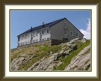
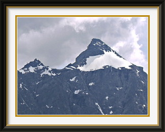
The Gleckstein Hut belongs to the Burgdorf Section of the Swiss Alpine Club. It lies on a rocky shoulder above the Upper Grindelwald Glacier with fine views across it to the Schreckhorn and its satellites. It is the starting point for the normal ascent of the Wetterhorn, 3690 M.
 We arrived to hot weather at the beginning of August in yet another year with
more than its fair share of days over 30°C. The snow had retreated to good
heights and would likely stay that way for some time. However, charging up at
once to great altitude would require a degree of fitness I hadn't built up yet.
A track which led into glacier scenery, but wasn't too demanding, would be ideal;
I chose the
Gleckstein Hut
on the slopes of the Wetterhorn above Grindelwald.
We arrived to hot weather at the beginning of August in yet another year with
more than its fair share of days over 30°C. The snow had retreated to good
heights and would likely stay that way for some time. However, charging up at
once to great altitude would require a degree of fitness I hadn't built up yet.
A track which led into glacier scenery, but wasn't too demanding, would be ideal;
I chose the
Gleckstein Hut
on the slopes of the Wetterhorn above Grindelwald.
The path started directly from a big car park opposite the Wetterhorn Hotel at the end of the public part of the road to the Grosse Scheidegg. At first, it headed unexceptionally through alpine meadows to the foot of the Wetterhorn's huge precipices. Here it made a hairpin turn towards the west and slanted up the western end of these precipices, sunless in the morning, with the Eiger's razor-sharp Mittellegi Ridge as a backdrop. As it climbed, the views of the Wetterhorn Hotel and the eastern "suburbs" of Grindelwald became ever more precipitous. Though the path is wide enough, this isn't a place for people with vertigo.
The journey so far had been shaded by the enormous bulk of the Wetterhorn, but the path suddenly turned a corner into the high Oberland and the slender Wyssbach waterfall and the Schreckhorn appeared in the morning glare. It continued for some time towards the southeast, following the lower part of the Upper Grindelwald Glacier, before turning northeast and becoming a little more challenging. The heat was quite noticeable by this stage a little after midday; the last time I had done this walk seventeen years earlier, helicopters had been collecting people overcome by the conditions, but now everybody seemed to be coping well.
At last the Gleckstein Hut appeared above, perched on a rocky promontory with a splendid view of the Upper Grindelwald Glacier. This a biggish hut, serving the Wetterhorn and other renowned peaks, but some of its operations have an engagingly domestic air. Note the fish! There was plenty of time to enjoy my sandwiches in the afternoon sunshine before I began to retrace my steps.

Le Grammont is a peak in the Chablais Alps lying across the eastern end of Lake Geneva from Montreux. The straightforward ascent from Le Flon is enlivened by the pretty Lac de Taney, and there are good views from the summit to Lake Geneva, more than a mile below. Arrive early at weekends, as the car park at the roadhead can fill quickly.
 The hot weather had petered out into days of cooler air and showers, but I
needed to get some more walking done. It was a murky day, allegedly
better towards the west, so I went about as far west as I could while
remaining in the Swiss Alps and drove past Montreux into the Rhône
Valley. A small road led from Vouvry up the slopes past Miex to the hamlet
of Le Flon, where it ended in a good-sized car park.
The hot weather had petered out into days of cooler air and showers, but I
needed to get some more walking done. It was a murky day, allegedly
better towards the west, so I went about as far west as I could while
remaining in the Swiss Alps and drove past Montreux into the Rhône
Valley. A small road led from Vouvry up the slopes past Miex to the hamlet
of Le Flon, where it ended in a good-sized car park.
From Le Flon a track led steeply northwest through forest to the even smaller hamlet of Taney. This also had road access, but via a road closed to all except four-wheel drive vehicles, so the great majority of casual tourists were excluded. The result was an exceptionally peaceful resort where a small number of visitors did mainly quiet things.
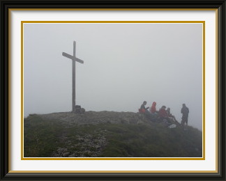
The weather report had been largely right about the murk, however; conditions didn't improve as I headed up towards the Col des Crosses behind the village, and cloud around the tops became thick mist shortly after I joined the handful of walkers on the grassy summit. Luckily I had memorised details of the tracks near the top, so I could descend through the fog without getting lost.
Back at Taney, the little lake of the same name gave a hint of how pretty it must be on a sunny day. Like many mountain hamlets, Taney has its own tiny chapel, locked, so I could take a photograph only through a window.
The Dent de Lys is a peak in the Fribourg Prealps lying between Châtel-St.-Denis and the upper Gruyère Valley. Being taller than any of its near neighbours, it has fine views in all directions. The usual ascent is up the southwest ridge, quite steep in places.
 The days since the last walk had not been promising, half cold and with more
rain than sun, but suddenly we had a morning of bright sunshine. The Congenial Swiss Lady
was free to do a walk, and it was time to get out. With the weather safer
towards the west, we chose the Dent de Lys, a peak at the extreme western
end of the Vaudois Alps looking out over the high farming country north of Montreux.
The days since the last walk had not been promising, half cold and with more
rain than sun, but suddenly we had a morning of bright sunshine. The Congenial Swiss Lady
was free to do a walk, and it was time to get out. With the weather safer
towards the west, we chose the Dent de Lys, a peak at the extreme western
end of the Vaudois Alps looking out over the high farming country north of Montreux.
The Dent de Lys is not a remote peak, and it can be approached from Les Paccots to the west or Montbovon to the east. Both approaches would be through actively farmed slopes, no doubt with a fair amount of cow dung en route. In the event, the western side looked more developed, with the roads reaching a higher altitude, so we decided to do it from the east. The drive took us past Lake Gruyere and along the Sarine Valley towards Château d'Oex, turning off the main road up the slopes to the village of Les Sciernes d'Albeuve, where there were convenient parking places.
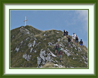
With the village and an initial walk up a road behind us, we could already just about make out the summit cross from the scattered houses at Chabloz. Another five hundred metres of ascent took us past the high grassy bowl at En Lys to the Col de Lys, where the surroundings grew more alpine and we could see up the ridge leading to the summit. The track skirted the worst part of the lower rock bands on the ridge, but still needed a section with chains before it could regain the ridge for the rest of the ascent. Nearing the summit, it became clear that we were far from alone on the mountain.
The summit had the regulation wooden cross and a fine view over Les Paccots and Châtel-St-Denis in the summer haze. Though a little crowded with walkers, we had space enough to enjoy our lunch in the sun.
To save time and to avoid the other walkers, we decided to descend via the trackless SE ridge. This was very steep in places, and it had views of the even steeper Grand Sex nearby, with a few plucky pine trees hanging on for dear life to what must be a very windswept crest at times. The route ended in a longish descent over an alpine meadow to Teraula d'Amont, tiring enough on steep grass without a track. Then we were once again on the mixture of roads and paths leading down to Les Sciernes d'Albeuve, pretty as a picture in the afternoon sun.
The Madom Gröss is a mountain in the Lepontine Alps near Sonogno at the end of the public road in the Verzasca Valley. It is the highest point on the Via Alta della Verzasca, a very dif ficult multi-day walk along the ridge separating the Verzasca Valley from the much busier Riviera and Leventina Valleys. It is directly accessed from the Alpe Costa Hut via at times ill-defined tracks.
 The time had come once again to take the wife and the relatives hosting us for
a trip. With the weather continuing cool and changeable, we chose the familiar
option of Locarno; being south of the Alps, we could expect it to be warmer
there at least. Also, while they roamed the shopping areas of the town and
took boat trips on Lake Maggiore, I could check out some of the hills I had
seen from
Monte Tamaro.
The time had come once again to take the wife and the relatives hosting us for
a trip. With the weather continuing cool and changeable, we chose the familiar
option of Locarno; being south of the Alps, we could expect it to be warmer
there at least. Also, while they roamed the shopping areas of the town and
took boat trips on Lake Maggiore, I could check out some of the hills I had
seen from
Monte Tamaro.
As the area was completely unknown to me, I drove up the Valle Verzasca to the end of the motorable road at Sonogno to scout out the peaks. In the upper reaches of the valley, the summits rise nearly 2000 metres above the road, making for precipitous views, but some of the very highest tops are hidden behind their lower slopes and not visible from the village.
When the day of the walk dawned, I left the hotel early and drove back up the valley to a convenient parking spot at Frasco. The weather looked reasonable; I would try the highest of the local peaks, the Madom Gröss. The first thousand metres of ascent proceeded through the usual mixture of forest and open grassland found at such heights. Finally the Rifugio Costa appeared at the top of a grassy slope. Behind the hut, the track ascended for a while before levelling off and beginning a wide curve along the 2000-metre contour towards the east. Forty or so minutes later and still at 2000 metres, it was clear that I had done something quite unusual for me... I had gotten lost. I knew that the peak lay to the north, and I had seen a fork in the path just behind the hut, but the hut was too far behind now; there was nothing for it but to force my way directly up the dense, low bush covering the steep slopes above the path to reach the wide terrace I knew lay below the summit. This succeeded - just - and soon I was facing the final ascent to the ridge between my destination and its neighbour, the Pizzo Cramoscino.
It was a relief to find white-blue-white markings once again, leading up a long boulder slide to the crux of the walk, a wet, near-vertical groove that needed body wedging to get enough grip on the slippery rocks. On the crest, the final, easy way to the summit was clear.
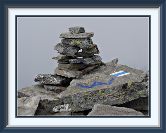
The summit boulders offered plenty of places to relax and eat my lunch snack. The blue paint markings in the photograph identify them as part of the Via Alta della Verzasca, a multiday trek along the summits which is rated as T6. Unfortunately the delays on the way up meant that afternoon cloud had risen enough to hide the views to the north of the peak, but I could see the village of Sobrio on the other side of the Leventina Valley and a train on the Gotthard Line nearly two and a half kilometres below.
On the descent, I was relieved to find a tarn I had seen mentioned in some walk descriptions, and more white-blue-white markings leading southwestwards. Iron discipline in following these, even when the next one was hard to find and the direction seemed wrong, led me back to the Rifugio Costa over more rockslides and rough ground than I was expecting. The path down to Frasco was easy by comparison, and offered some nice evening views of the Valle Verzasca.
The Hockenhorn is a summit on the ridge separating the upper Gastern Valley and the Lötschental. It lies near the Lötschen Pass and is the highest point on the ridge until it reaches the summits of the Lauterbrunnen Valley far to the northeast. It is also the highest point in the Bernese Alps reachable by what might be considered a walking trail.
 While we were away, the weather north of the Alps had reverted to more typical
levels of warmth for August, and daily maxima were once more above 30°C. It
was time to go high; where better than the highest conventionally walkable
peak in the Bernese Oberland,
the Hockenhorn? The northern approach
is from Kandersteg Village,
and part of the charm is that it is perfectly
practical to go down the other side of the Lötschen Pass into the
Lötschen Valley and make your way to Goppenstein, from where the train
takes you back to Kandersteg through one of the great old Alpine tunnels.
While we were away, the weather north of the Alps had reverted to more typical
levels of warmth for August, and daily maxima were once more above 30°C. It
was time to go high; where better than the highest conventionally walkable
peak in the Bernese Oberland,
the Hockenhorn? The northern approach
is from Kandersteg Village,
and part of the charm is that it is perfectly
practical to go down the other side of the Lötschen Pass into the
Lötschen Valley and make your way to Goppenstein, from where the train
takes you back to Kandersteg through one of the great old Alpine tunnels.
I had been more than once to this peak and had always eschewed taking the little bus to Selden at the foot of the final ascent to the pass, instead doing the full walk from the back of the valley behind Kandersteg. On the descent into the Lötschen Valley, however, a mixture of impatience and laziness had led me to stop when I reached the valley road and catch the bus for the last few kilometres down to Goppenstein. This time, it would be different; I would attempt to walk every bit of the way from the end of the free road beside the northern portal of the Lötschberg tunnel to Goppenstein station at the southern portal.
Accordingly, I made an early start from the Eggenschwand car park at the road's end and, an hour and a half later, I finally left the young Kander Stream and the easy part of the walk. The well-formed track snaked up the grassy slopes above Gfelalp, looking down on the Kander, its bed scoured and widened by last year's deluges. Along this stretch are some of the best views of the strange, turreted south face of the Doldenhorn. At only about 2400 metres, it is something of a surprise to step onto ice, but the path here is shaded from the afternoon sun by the enormous precipices of the Balmhorn to the west. The Lötschen Glacier is today mostly covered by rubble and is easily crossed where it is marked by poles. At last the track ascends cliffs to reach the Lötschen Pass and the eponymous hut, a splendid place to stop for a brief snack.
Heading northeast along the ridge from the hut, there is at first no sight of the Hockenhorn. There are scraps of path, but if in doubt, it is only necessary to take the easiest route up the gentle slopes. About seven hundred metres from the hut, you can enjoy the minor curiosity of standing on a point some 1585 metres vertically above the old Lötschberg railway tunnel and simultaneously a little over 2000 metres vertically above the new one where it crosses the old one at an acute angle far below. The exact spot lies less than fifty metres from the track (such as it is), but it is not marked. It seems to me that the builders of the new tunnel have missed an opportunity to remind walkers of their achievement here. Past the 3000-metre contour, the peak is in full view ahead and the walking is absolutely easy for a while, but the path eventually fades away and the terrain below the summit reverts to type for the altitude. The few patches of permanent snow pose little difficulty, however, and the route is soon making its way up through the layered rocks of the summit pyramid.
The summit has one of the most magnificent views imaginable of the Bernese Oberland. Far to the east, the great bulk of the Aletschhorn (at 4195 M. the second highest peak in the whole area) rises above the glaciated upper reaches of the Lötschen Valley. Turning towards the north, the Blümlisalp Range shows a less familiar aspect without the heavy glaciation that makes its northern faces so picturesque. Rounding to the northwest, the hamlet of Selden and my path through the upper Gastern Valley lay far below. And southwards, I could even see my ultimate destination, the railway station at Goppenstein in the gorge where the Lonza River flows down to the Rhône Valley.
I had an hour to relax and enjoy the warm sun and the wonderful panorama. On both previous visits to this lucky summit, conditions had been just as good, not something you expect at this altitude. Now with an eye on the clock, I retraced my steps to the hut, where I made another brief pause beside one more fine example of the Cairn Fairy's work as the shadows began to lengthen. Then I began the long trek down to Kummenalp and Ferden, arriving in Goppenstein as the last glimmer of light faded from the sky. My luck continued, with a train arriving as soon as I stood on the platform; the next and last one was an hour and a half later. In barely more than fifteen minutes, I was back at my car.