


The Honeggerhorn is a mountain on the south side of the Bernese Oberland. It lies above the village of Bellwald in the Goms, the uppermost stretch of the Rhône Valley in the Canton of Valais. Of modest size itself, it looks out on bigger peaks nearby, like the Täschehorn (3007 M.) and the Galmihorn (3506 M.).
 After a couple of days of rain early in September, a day of mist giving
way to sunshine followed, and the morrow promised to be cloudless and clear.
I thought I would try the Täschehorn above Bellwald; it was in an area
quite unknown to me, but there were various lower summits like the Honeggerhorn
around it in case it proved hard to access.
Accordingly I was off before dawn to put the car on an early train through
the Lötschberg Tunnel and drive down to Brig and back up to the tourist
resort of Bellwald on the southern slopes of the Bernese Oberland. The path
from the big free car park below the village led through the old centre,
where there was no shortage of
information for walkers.
After a couple of days of rain early in September, a day of mist giving
way to sunshine followed, and the morrow promised to be cloudless and clear.
I thought I would try the Täschehorn above Bellwald; it was in an area
quite unknown to me, but there were various lower summits like the Honeggerhorn
around it in case it proved hard to access.
Accordingly I was off before dawn to put the car on an early train through
the Lötschberg Tunnel and drive down to Brig and back up to the tourist
resort of Bellwald on the southern slopes of the Bernese Oberland. The path
from the big free car park below the village led through the old centre,
where there was no shortage of
information for walkers.
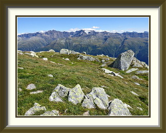
A somewhat charmless mix of paths and roads led to the chairlift station at Flesche, after which the path towards Chiebodma was more appealing. A little higher up, there were fine views of the big Valaisian peaks in the clear air. Still higher up, the track passed the Spilsee and the Mittelsee, then a nameless tarn a little below the summit of the Honeggerhorn.
At the saddle, just minutes away from the summit to the south, I turned instead towards the ridge extending at first gently towards the northwest. It ended at a range of summits about a mile away which looked down on the lower reaches of the Fiescher Glacier, one of the longest in the Alps. Though steep, they would be worth some effort for the view. I picked my route along the now pathless ridge, losing a little time in searching for the best way across the somewhat featureless, humpy terrain. There were fine views on the way of the Galmihorn, looking even taller than its 3500 metres, before I stood at the foot of the Täschehorn.
The terrain now became much stonier. A handful of red paint marks provided not so much guidance as the bare knowledge that I wasn't lost yet. At the foot of a smooth rock rib perhaps a hundred metres below the Täschehorn's summit, I was faced with a choice; I could skirt it on the left up mixed rubble and boulders, or head right up similar, but steeper and bigger material. Minutes of careful scanning failed to reveal any more paint marks on either side, and I had to face the fact that time had run out, given the long journey home from Bellwald.
Having retraced my steps to the saddle, I needed to cross only a few mildly interesting rocks to reach the Honeggerhorn's remarkably benign summit, where I had a late lunch to the spectacle of the endless peaks along the Italian border on the other side of the Rhône Valley. As I descended towards my car, the settlements of the Goms stretched into the distance in the afternoon sun.

The Grand Muveran is the westernmost 3000-meter peak of the Bernese Oberland, lying inside the ninety-degree angle made by the Rhône at Martigny. The summit lies on the border between the cantons of Vaud and Valais. The mountain presents steep, rocky faces on all sides, and there are no easy paths to the summit. The usual access is from the Rambert Hut to its southwest.
 With the warm and stable late summer weather continuing, it was time to
tackle something a little more interesting. Just before the Bernese Oberland
peters out in the elbow of the Rhône Valley at Martigny, it rises
for the last time to 3000 metres at the Grand Muveran, a peak I had seen
from various neighbours over the years. Too far west of the Lötschberg
for the tunnel to be worth it, getting there involved the same journey
down the Autobahn past Montreux and Martigny done so many times before.
From Leytron, a narrow road wound its way up to the little ski resort of
Ovronnaz. Once there, I needed to get to my destination at Chamosentse via Loutse, but
it was only on the third try that I found the turnoff for the latter. A
narrower road wound its way up the hill, but when I arrived at Loutse it
was to find that I had once again gone wrong; the junction for Chamosentse
was already below. Retracing my route, I found the unmarked turnoff onto
a gravel road. The rest of the journey was reminiscent of roads
in Southern Africa before the surprisingly comfortable parking beside the road's
end at Chamosentse Alp.
With the warm and stable late summer weather continuing, it was time to
tackle something a little more interesting. Just before the Bernese Oberland
peters out in the elbow of the Rhône Valley at Martigny, it rises
for the last time to 3000 metres at the Grand Muveran, a peak I had seen
from various neighbours over the years. Too far west of the Lötschberg
for the tunnel to be worth it, getting there involved the same journey
down the Autobahn past Montreux and Martigny done so many times before.
From Leytron, a narrow road wound its way up to the little ski resort of
Ovronnaz. Once there, I needed to get to my destination at Chamosentse via Loutse, but
it was only on the third try that I found the turnoff for the latter. A
narrower road wound its way up the hill, but when I arrived at Loutse it
was to find that I had once again gone wrong; the junction for Chamosentse
was already below. Retracing my route, I found the unmarked turnoff onto
a gravel road. The rest of the journey was reminiscent of roads
in Southern Africa before the surprisingly comfortable parking beside the road's
end at Chamosentse Alp.
The only problem for walkers here was picking a destination (..."Rambert" in my case). After an ascent up at times gentle grass slopes, the track began to skirt fields of boulders, and before the grass had faded away, I passed an interesting deconstruction of the concept of the Swiss Wanderweg signpost. A little further up, rising cloud was gracing the magnificent stone scenery, but though it remained all day, it gradually became more stable by afternoon and never hid the views entirely. Not long afterwards, I was standing at the Cabane Rambert, heavily modernised in 2015. The gleaming annex at the rear houses a compact nuclear power unit for the winter months1.
It had to be said that, seen from the hut, the south face of the Grand Muveran didn't look all that walkable. Where, for example, was the summit? (...It's the tiny rounded knoll a little to the left of centre and above a long shaded rib.) Heading up the path towards the mountain proper, I saw that I would not be alone. Soon the path turned left into a chimney leading onto the ridge and the face. Barely fifteen metres up the chimney, I was wedged in an increasingly narrow and tortuous slot, struggling to proceed. Then I noticed a red mark on the rocks well to the left... I had taken the implied steepness too literally. With a certain amount of gasping and grunting, I extricated myself carefully from my predicament and climbed the correct chimney with less fuss.
Once on the ridge, the way ahead was clear, complete with a small plaque commemorating a fallen walker pour encourager les autres, no doubt. Just alongside it, a solitary piece of chain provided security, the only one on the mountain. A rattle of stones nearby was a reminder that I wasn't the only species on the slopes that day. From this point on, the walk was a constantly interesting traverse of the Muveran's whole southern face along narrow ledges. Less obvious parts were generously marked with coloured paint splotches, but why all the different colours I have no idea. Once or twice the path, such as it was, became very indistinct, and then the splotches were quite useful.
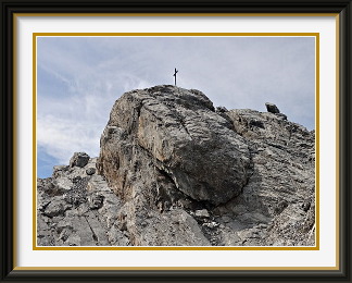
At last, the ledges gave way to a period of light scrambling, above which the summit rocks hove into view. The summit has a finely-crafted cross with a rather less finely-crafted lightning conductor. Just in case the infidels weren't getting the message, somebody had painted an explanation on the neighbouring rocks. I had plenty of time to enjoy the views, though the cloud hid many of the more distant peaks. The hut and the oddly-named Pointe de Chémo behind it were nicely visible, with the Rhône Valley in the distance more than than 2500 metres below, but I had to wait until I was back at the hut before I had a good view of the fine stony peaks to the east.
The Col de Tsarmine is a saddle between the Petite Dent de Veisivi and the Grande Dent de Veisivi (3419 M.). It is reached by a track from the hamlet of Satarma in the Arolla Valley. Though not dif ficult, the track was poorly marked in 2016 and little frequented, so it is not a place for beginners.
 Even mid-September, the warm weather was still holding out, so I needed to use
every precious opportunity. The most rewarding walks I could think of were all
in the Valais, so once again I drove down the same motorway to Martigny, then
further up the Rhône Valley to Sion, before turning into the high mountains
at the Val d'Hérens. A final stretch up the smaller Arolla Valley took me
to the tiny hamlet of Satarma, from which a track of sorts was said to lead to
the Col de Tsarmine. Lying between two fairly steep peaks, the col promised to be
at least moderately interesting.
Even mid-September, the warm weather was still holding out, so I needed to use
every precious opportunity. The most rewarding walks I could think of were all
in the Valais, so once again I drove down the same motorway to Martigny, then
further up the Rhône Valley to Sion, before turning into the high mountains
at the Val d'Hérens. A final stretch up the smaller Arolla Valley took me
to the tiny hamlet of Satarma, from which a track of sorts was said to lead to
the Col de Tsarmine. Lying between two fairly steep peaks, the col promised to be
at least moderately interesting.
From the unformed lay-by just above Satarma, it was a short walk down the valley to the start of the track across the road from the village. No Wanderweg signposts here, just a carved wooden pointer to Tsarmine, the alp below the pass. The modest path led steeply upwards through relatively bushy woodland, but the shrubbery was never quite enough to obscure the way. Near the tree line, it crossed the bed of a mountain torrent more than usually choked by boulders. As it climbed, I spied just a handful of ancient, faded paint marks, indicating that this track had once upon a time been more frequented. Though it appeared on the standard LK, it was not outlined in red in my walkers' version, as it would be if the mapmakers regarded it as popular. At this stage, there was a good view of tiny Satarma and the valley floor below.
Above the solitary chalet at Tsarmine Alp, the ground became ever more stony. Some of the boulders were quite colourful, and a few were very colourful indeed. The last stretch of the track climbed steeply along the foot of the precipices of the Petite Dent de Veisivi to reach the smooth rock slabs below the Col de Tsarmine ahead.
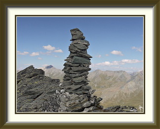
The first thing to notice on the col was a fine example of the Cairn Fairy's work, the only significant one all day. To one side of the pass, the Grande Dent de Veisivi reared into the sky, allegedly walkable, though looking rather daunting. In any case, there wasn't enough time to try the extra four hundred metres or so, given the long journey home. On the other side, the pinnacles of the Petite Dent de Veisivi were the territory of people with ropes, two of whom I had met on the way up. To the west, below the Aiguilles Rouges d'Arolla, I could trace much of the route of last year's walk up the Mont de l'Etoile. Further away to the north, the panorama included another old walk, the Sasseneire.
After a leisurely afternoon snack, I set off back down. The upper stretch of the path has fine views, not only of the Grande Dent de Veisivi, but of the Blanche de Perroc behind it. During the descent, the sky grew duller and cloud began to envelop the summits of the Pigne d'Arolla and Mont Blanc de Cheilon at the head of the Arolla Valley. Cloud, as it turned out, which heralded the true end of the summer; the next walk would take place in cooler conditions.
Mont Rogneux is a mountain in the Pennine Alps lying to the east of the Great St Bernard Highway in the Val d'Entremont. Access is from the roadhead at Chandonne via the Col de Mille. There are fine views of the Mont Blanc and Combin Massifs, though not on the day I was there. This mountain is not to be confused with the peak of the same name above Verbier.
 Autumn had announced itself with a series of rainy days, at times almost cold.
After nearly a week, a short break in the gloom offered the last chance to get
out. There was fresh snow on the heights of the Bernese Oberland; though September
snow almost always disappears again before the arrival of winter, I would not be
around long enough to take advantage of that. It would still be necessary to go to the
Valais, where the snow would at least start higher up.
Autumn had announced itself with a series of rainy days, at times almost cold.
After nearly a week, a short break in the gloom offered the last chance to get
out. There was fresh snow on the heights of the Bernese Oberland; though September
snow almost always disappears again before the arrival of winter, I would not be
around long enough to take advantage of that. It would still be necessary to go to the
Valais, where the snow would at least start higher up.
So it was that I drove yet again the long journey to Martigny, turning this time up the Great Saint Bernard road. At the village of Liddes, I left the highway for the hamlet of Chandonne near the end of the public road. Given two possible ways up to the Col de Mille a thousand metres above, I chose the Sentier des Éperviers, the "sparrowhawks' path", whose signs promised a selection of wildlife along the way. In the event, I didn't see anything all day; perhaps it was the wrong season. The well-maintained path gained height rapidly though forests before passing the picturesque ruins of the farm buildings at Erra d'en Bas.
At the Col, there was a plethora of choices for walkers, offering excursions from a few minutes up to seven hours. The way to Mont Rogneux was the only one marked in blue, and the rest of the track was well marked with the white-blue-white paint reserved for slightly harder walks2. Above the Col, the ridge became stonier while rising cloud began to eat away at the views. As the track climbed in broad hairpins up the long ridge, the last grass gave way to the first snow between the boulders. Not long afterwards, the snow cover was more extensive and, particularly on the eastern side of the ridge, the conditions demanded care. On the mountain's lower western summit, there was a sort of heavily constructed bivouac shelter. Whether it was built by the army, some alpine club or the Bivouac Fairy, I couldn't tell. In the damp and cold conditions, it didn't look very inviting, so I didn't explore.
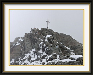
A short walk across flat terrain took me to the main summit where, despite all the snow, it wasn't hard to find a dry stone to sit on for lunch. Unusually, the mountain's name plaque wasn't mounted on the cross, but on a random boulder nearby. You could easily have missed it. "Cette croix est dédiée à la memoire d'amis disparus sur cette montagne. Montagnard respecte-la" said a small wooden plaque at the bottom of the cross. Whether this plea was a response to the recent chopping down of several mountaintop crosses by some clown wielding an axe wasn't clear; it looked too old for that. The rising cloud had not relented, and as I watched, the slightly higher Grand Aget along the ridge disappeared for good.
It was cold and, even with gloves, my hands were starting to freeze, so I did not remain on the summit as long as I would have liked. Though the snow extended well below the summit, it never posed a problem. It had lain long enough to be pleasantly crunchy, but not yet icy, and the walk's summer rating of T4 could stand. Descending the ridge, I could see distant Verbier through a hole in the thickening clouds. It did not bode well for walkers in the following days. The Southern Hemisphere beckoned.