


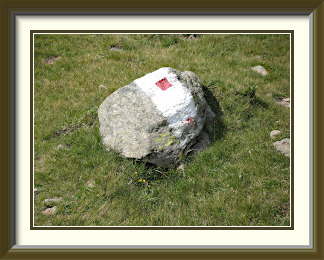
The Elsighorn is a mountain in the Bernese Oberland overlooking Frutigen at the fork of the Kander and Engstligen Valleys. From the hamlet of Elsigbach in the latter, a mix of paths and roads leads to Elsigenalp, where an easy track leads over gentle slopes to the summit, from which steep and impressive views down into both valleys are suddenly visible. This is a good place to see the loops of the old Lötschberg railway as it makes the ascent towards Kandersteg.
 A week's visit to Ireland and other things meant that it had been a fortnight
since the last walk, so I looked for something fairly easy to get things going
again. A check through my diaries showed that I hadn't done the Elsighorn for
more than twenty years. With its central position overlooking the junction of
the Kander and Adelboden valleys, there would be some precipitous views, and with
the warm weather just about holding, conditions looked good.
A week's visit to Ireland and other things meant that it had been a fortnight
since the last walk, so I looked for something fairly easy to get things going
again. A check through my diaries showed that I hadn't done the Elsighorn for
more than twenty years. With its central position overlooking the junction of
the Kander and Adelboden valleys, there would be some precipitous views, and with
the warm weather just about holding, conditions looked good.
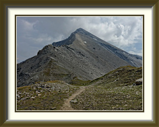
The walk could have started from the main Adelboden road, but there were no parking spots nearby, so I had to drive up a narrow side road to Elsigbach, losing a harmless couple of hundred metres from the total ascent. Here, a cable car to Elsigenalp offered free parking and the next best place to start. A mixture of alp roads and a typical forest path, steep at times, led to the upper station of the cable car. I contrived to miss the forest path bit on the way up, and so walked more road than necessary. Nearing the upper station, there was a new perspective on the Gsür (...described here). Behind the station, the Elsigenalp opened out, a gently-sloping area with a few restaurants and tourist chalets. The path above this towards the Elsighorn could best be described as harmless, and the summit made no impression as it was approached.
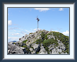
That all changed on arrival at the peak, when the Elsighorn revealed itself to be just about the best possible viewpoint over the lower Kander Valley. Below its steep northern slopes, Frutigen village and its railways were laid out like a map. The view down to the road to Kandersteg was even more precipitous. The loops of the old Kandersteg line, quieter now since through trains started using the new 35-Km. tunnel, could be seen a little further to the south. A local train can just be made out traversing the main loop.
Across the Engstligen Valley, the regular pattern of roads and houses up the slopes of the Hohniesen peak in the Niesen chain caught the eye. More striking by far, however, were the views of the high peaks behind Kandersteg. With rain on the way by evening, the clear air hid nothing of the detail of the Balmhorn and the Altels, and on the way down the Elsighorn's gentle southern slopes, the Blümlisalp Chain and the Doldenhorn made a splendid backdrop.

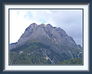
Piz Lischana is a mountain in the Sesvenna Alps, otherwise known as the Engadine Dolomites. It overlooks Scuol in the Lower Engadine and appears in many a calendar picture of that town. The track to the summit starts a little above the town in the woods and passes the Lischana Hut. The last part is along a ridge above 3000 metres. The summit rocks are unstable, and the last few metres of the track are nominally closed. There are fine views of the Lower Engadine below, although Scuol itself is obscured by a lower outcrop.
 Things had changed. The wife had gone overseas on family business for two
weeks; I could sit around doing the usual things (and the usual walks), or
I could make the most of the situation and go somewhere where I could try
peaks too far away to be considered normally. The most flexible way to do
this would be to camp again, so I decided to go back to the same campground
we had used last month. The facilities were good, and I would be able to manage
on my own. And Graubünden has loads of mountains...
Things had changed. The wife had gone overseas on family business for two
weeks; I could sit around doing the usual things (and the usual walks), or
I could make the most of the situation and go somewhere where I could try
peaks too far away to be considered normally. The most flexible way to do
this would be to camp again, so I decided to go back to the same campground
we had used last month. The facilities were good, and I would be able to manage
on my own. And Graubünden has loads of mountains...
Safely ensconced in Scuol, I cast around for a summit to start with. There was one of medium height not far up the valley, but I couldn't be sure of finding a parking place at its foot. With fickle weather in store, I decided instead to go straight for Piz Lischana, one of the dolomitic peaks making up Scuol's deservedly famous chocolate-box backdrop. The peak is served by a hut, and there are parking places at the foot of its track, just a few minutes up a small road from the campsite. The easy, marked track led up through woodland and then open, grassy slopes for more than a thousand metres, until the hut, the Chamanna Lischana was finally visible on a promontory between Piz Lischana and its equally steep neighbours.
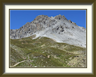
Beyond the hut, the terrain became stonier. Five hundred metres higher, the track skirted an impressive rock peak to the edge of a barren and surprisingly extensive plateau around the Fuorcla da Rims. There, however, it veered northwest, skirting the plateau, through an arctic-looking landscape to reach a top identified only as Point 3044. No great destination in itself, it is nevertheless the first place where one can see the rest of the way to the summit. The fine thread of the path across ridges and flanks can be seen in the picture. A brief, steep scramble led to the of ficial summit at 3100 metres, where the cairn and summit book were to be found. But... the peak is 3105 M. high, so what gives? Well, in 2011 part of the summit pyramid collapsed, so the local authorities not unreasonably want people to stay away from the edge of the vertical drop left behind. Given that nothing more had fallen away in the last eight years, I supposed that I could risk a couple of minutes up there. Apart from the 360° view, all I found was what I suppose were the untidy remains of the original summit cairn. It did provide a fine view back down the track from Point 3044, the tan-coloured hump to the left of centre in the picture. At the far end of the high, stony wilderness, the tallest of the rocky peaks is Piz Sesvenna, the highest point in this particular group of mountains. The snow-capped peaks half hidden by cloud include the Ortler (3905 M.), the highest point in the Alps east of the Bernina Group, and situated entirely in Italy. Point 3044 rises above a patch of ice and rubble, all that remains of the Lischana Glacier, which covered four square kilometres in 1850 and reached nearly down to where the Chamanna Lischana now stands on its promontory far below. Despite its prominence, the peak wasn't the best for valley views; the Lower Engadine's modest villages and roads were too far down to stand out much. Scuol was partly hidden, but I could capture a decent view of some villages further down the Lower Engadine in the afternoon light.
Leaving the summit, I could see that the local authorities were right to be concerned. Another big slice was separating; the crack was already some tens of centimetres wide and it was only a matter of time. The rest of the journey down was uneventful, even a little tedious in the forested stretches. It was relieved at times by Lischana's cliffs, now far above and glowing in the evening sun.
Munt da la Bes-cha (not to be confused with the peak of the same name above Pontresina) is a shoulder of the much steeper Piz Nair above Ardez in the Lower Engadine. Its summit is basically a meadow despite the altitude. It has a shoulder in turn, Crap Putèr, which has benches and a much better view along the Lower Engadine.
 Two days after the last walk, rain had come in during the night. When I walked into
Scuol town to get breakfast, I could see through a gap in the clouds fresh snow
on Piz Spadla, a peak above the town which was less than three thousand metres high.
The clouds were thinning fast, however. All I had to do was pick something lower.
Two days after the last walk, rain had come in during the night. When I walked into
Scuol town to get breakfast, I could see through a gap in the clouds fresh snow
on Piz Spadla, a peak above the town which was less than three thousand metres high.
The clouds were thinning fast, however. All I had to do was pick something lower.
An unspectacular summit nearby was Crap Putèr1, and just above and behind this was Munt da la Bes‑cha, still safely below any fresh snow. They would do.
Incidentally, what do the two hyphenated words Bes‑cha mean? Well, they are not two words at all, but one, meaning "sheep"; the German name for the mountain is "Schafberg". Without the hyphen, "sch" would sound as it does in "sheep". With it, the sound intended is like the "sch" in "eschew". This I discovered only from someone I met on the summit of Piz Minschun in July, after forty years of wondering what place names like S‑charl and Chamues‑ch meant!
Just a short drive from Scuol, I parked the car in the pretty hamlet of Fontana at the foot of the rocky promontory supporting the almost ridiculously picturesque Schloss Tarasp. A quarter of an hour up the road behind Fontana, there were more parking spots at the end of the public road; I should have been bolder! There followed well over an hour of ascent up sometimes quite wide and well-formed alp access roads. As ever, they converted a walk into a trudge, and it was with some relief that I found the start of a genuine walking track through the woods at 1,950 metres. Barely another four hundred metres were needed to arrive at Crap Putèr's modest summit, where a few placid sheep moved away as I arrived. Despite its lack of height, it had a perfectly decent view past Scuol to a still-snowcapped Muttler on the horizon. Though there were a couple of inviting bench seats, I didn't stay long. A series of modest rises behind Crap Putèr led to Munt da la Bes‑cha. Stony in part, they had no official path, but enough sheep tracks that there was little risk of getting stuck. On top, I was confronted by... a meadow, almost, not something I would expect to find at the same height in the Bernese Oberland. The lush grass was full of droppings, but there were no sheep in sight. Perhaps the recent snow had driven them down a bit?
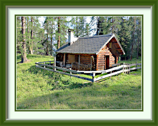
That was as far as I was going to get. The next thing along the ridge was Piz Nair, clearly not in the same league. I retraced my path through the stones and the sheep tracks and back into the woods, where in the middle of nowhere there was a charming little chalet, evidently in use, though there was nobody to be seen.
Piz Umbrail is a mountain on the Swiss-Italian border above the pass of the same name south of the Val Müstair (Münstertal). The great height of the pass means that the ascent from the road is quite short, but there are good views in all directions from the summit, including of the giant Ortler (3905 M.) across the border. There can be a nuisance from mountain bikers using the track at times reserved for walkers, also from those of the motorised kind riding dangerously on the tricky road to the pass from Santa Maria in the valley.
 The forecast for the day had been hot, with thunderstorms moving in. As it turned
out, the weathermen had been too fast on the trigger, and the weather in the morning
was warm, but cloudless and clear. I didn't feel that energetic, but it would
be a pity to waste such perfect conditions. Piz Umbrail is over 3,000 metres, but
the motorable pass of the same name where the walk starts is already at 2,500, so
that would make for an easy, but still alpine, day.
The forecast for the day had been hot, with thunderstorms moving in. As it turned
out, the weathermen had been too fast on the trigger, and the weather in the morning
was warm, but cloudless and clear. I didn't feel that energetic, but it would
be a pity to waste such perfect conditions. Piz Umbrail is over 3,000 metres, but
the motorable pass of the same name where the walk starts is already at 2,500, so
that would make for an easy, but still alpine, day.
It was a journey of over 75 Km. from Scuol to get there, over the Ofenpass and down into the Val Müstair, then up the narrow and difficult Umbrail road. Dozens of motorcyclists made for tense driving conditions at times. They overtook as if they were sure that I could see them in my rear-view mirror, but half the time they were already past before I noticed them. The border with Italy is at the crest of the Umbrail, and I ended up parking in Italy since all the places on the Swiss side were taken. With the Italian border post some distance down the road, nobody was checking documents.
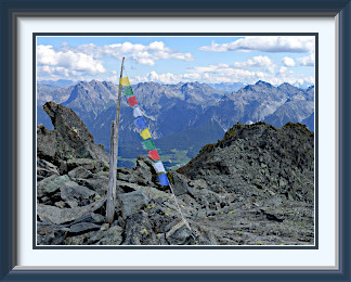
The track began right at the pass. Not far from the road, it was clear that Piz Umbrail was a perfectly reasonable target, even if the height difference wasn't great. The walk was distinguished by a significant number of old military structures, like this command post. These date from World War One, when the army was posted here to make sure that the fight didn't spill over into Switzerland. After a while, the track left the grass and proceeded up the mountain's stony eastern side. The rest of the ascent was in much the same vein, though it grew steeper near the summit. I arrived to a splendid view in all directions. Close by to the north were Piz Chazforà and Piz Rims and their colourful scree slopes. Standing here on the Swiss-Italian border, I could see between these two tops the distant pointed summit of the Fluchthorn on the Swiss-Austrian border beyond Scuol.
I was less than thrilled to find a number of mountain bikers cluttering the area with their machines, which they left lying here and there at random while they made noisy chatter. I had some justification in disliking them; the local authority had put up a sign politely inviting the bikers not to use the path in the middle of the day for the safety of walkers. Sorry, Cumün da Val Müstair, it's going to have to be prohibition…
Fortunately, the peak is at the end of a long ridge extending almost level for some distance to the west, so I could just stroll a short distance along it to take a photo of Piz Umbrail's summit with its background of South Tyrolean mountains. There is a fine view down to the uppermost hairpins of the Stelvio Pass road, the second highest surfaced pass in the Alps, but the best part of the view on a clear day is undoubtedly the hulking mass of the Ortler, at 3,905 metres the tallest mountain that far east in the Alps.
There were also small things to be seen; a surprising number of plants seem to be able to survive at 3,000 metres now, like this one, some sort of Yarrow perhaps?
Piz Chavalatsch is a mountain on the Swiss-Italian border above the village of Müstair in the Val Müstair; its summit is the easternmost point of Switzerland. Tracks access it from Müstair and also from the Italian side, where the way is suitable for mountain bikers. The summit area is also reachable by livestock despite the altitude.
 The plan had been to walk every second day, but the last three days had had
rain both morning and evening, often fairly heavy, and with lightning. Now the
fourth day began with milky skies, but only a modest amount of morning cumulus.
Better not miss a chance! To make the best of that chance, I decided to head back to
the Val Müstair; deeper into the Alps, it might escape any rogue showers
coming from the northwest. There was a peak there of no great distinction to
walkers, but a curiosity as the easternmost point of Switzerland… Piz
Chavalatsch. That was enough reason to try it.
The plan had been to walk every second day, but the last three days had had
rain both morning and evening, often fairly heavy, and with lightning. Now the
fourth day began with milky skies, but only a modest amount of morning cumulus.
Better not miss a chance! To make the best of that chance, I decided to head back to
the Val Müstair; deeper into the Alps, it might escape any rogue showers
coming from the northwest. There was a peak there of no great distinction to
walkers, but a curiosity as the easternmost point of Switzerland… Piz
Chavalatsch. That was enough reason to try it.
As much by luck as anything else, I found a parking spot for walkers by the banks of the Rom river with many Wanderweg signposts, though none directly referencing the peak. After ten minutes or so walking between the river and some wooded bluffs memorably called the Crippels, the real walk started with a perfectly standard slog up through pine woods. After a big zigzag up the hill, I was surprised to meet a track apparently coming more directly from where I had started, but thought no more of it. The path continued up through the woods, becoming steeper near an area called Plaun Radond. There was no quick end to the trees here, rather, they thinned out and asymptotically approached zero size as one approached the summit; some of the top ones were inches tall.
Above Plaun Radond, the markings became a bit odd; there were some all-white ones and ones like this. I could imagine an argument between Mr. White Paint and Mr. Red Paint. Mr. Red Paint: "Vertical lines!". Mr. White Paint: "No, we paint horizontal lines!". Mr. Red Paint: "No, vertical lines!". Mr. White Paint: "No, no, horizontal lines!". Mr. Red Paint paints a vertical red line. Mr. White Paint has to go along by painting the two white lines vertically. he plots revenge and sneaks back up that evening to make his horizontal lines leaving not a lot of Mr. Red Paint's work visible. Heaven knows what the real reasons were, but the conventional markings resumed along the grassy slopes below the summit.
A short walk up the mountain's western ridge from the saddle called La Scharta led to the summit, where the track (and the border) skirted an Italian customs hut to reach Piz Chavalatsch's flat top, all Swiss territory. Unfortunately, there were more noisy mountain bikers there. Couldn't blame them, as there was a more substantial path leading up from the South Tyrol (Italian) side, and no evidence of prohibition. They set off after a while, leaving me in the company of the most easterly cow in Switzerland; there was grass even at this altitude. The views were extensive, of mostly unknown mountains all around, and the border area from which I had set off below. (The border is not the neat line of trees in the picture, but the small, straight road to their left.)
The journey down was uneventful, except that I took the more direct path noticed on the ascent, which led steeply down through the forest and had some sunken sections which looked as if they had been cut. At the bottom, I was surprised to arrive right at the car park. There had been no reason to walk along the river at all, but for some reason they had carefully avoided signposting it. Fortunately, the Rom had not been forced into a deep channel at this point, so I enjoyed a pleasurable foot-cool before driving away.
The Muttler is the highest mountain of the Samnaun Group, a region of the Alps extending from the Lower Engadine across the border as far as Landeck in Austria. Access is from the village of Samnaun, where there is good parking because of its status as a duty-free zone. The ascent is via the saddle called the Rossbodenjoch and then more steeply over slabs of slate to the summit. As the highest point in the area, its views are impressive in all directions. Transmitter equipment west of the summit has been removed.
 The recent weather pattern continued. The evening of the last walk had had heavy
rain, and more rain had fallen on the next day. Now a humid morning was starting
with ragged scraps of cloud draped across the mountains at every level. Were they
the remnants of yesterday's weather or the start of today's? No point in waiting
to find out. There was a peak near the tax-free zone of Samnaun with, despite its
considerable height, path markings all the way to the top. The danger of being
caught in a storm would be less there.
The recent weather pattern continued. The evening of the last walk had had heavy
rain, and more rain had fallen on the next day. Now a humid morning was starting
with ragged scraps of cloud draped across the mountains at every level. Were they
the remnants of yesterday's weather or the start of today's? No point in waiting
to find out. There was a peak near the tax-free zone of Samnaun with, despite its
considerable height, path markings all the way to the top. The danger of being
caught in a storm would be less there.
The tourist haunt of Samnaun was soon left behind, and on the pleasantly green initial path, the morning clouds were still hiding the tops of the Muttler and its neighbour, the Stammerspitz. The element of suspense continued... would the clouds rise as the sun got higher, or would they grow to envelop more of the mountain? The easier part of the path ended at the saddle called the Rossbodenjoch, and to my enormous relief, the summit was still visible at least some of the time. The Muttler's north ridge loomed 550 metres above, getting steeper all the way. It was a long ascent through fields of slabby rock, the ground turning to dark, shaly mud as the summit grew closer.
With gratifying suddenness, the summit signpost came into view; it hadn't been visible fifteen metres below. The summit itself was a slightly cluttered but comfortable area, with enough places to sit down while the rising mist came and went. Alongside the signpost and summit book holder, there was evidence that the cairn fairy had been at work. While the clouds still hid most distant views, there was a fine view north to the Stammerspitz, and the whole ascent route from Samnaun appeared through the rising mist now and then.
I spent less time on the summit than usual. With the peaks beyond Scuol already hidden by rising cloud and haze, it was wise to begin the descent after only twenty minutes; weather conditions like these can quickly tip over into thunderstorms. A few drops of rain did fall just as I was starting, but fortunately it never came to anything worse. A couple of hours later, I was once more on that pleasantly green lower path above Samnaun. When it broadened to a motorable track just above the village, it was clear that something had happened since I had set off in the morning. A slow slip of mud and rock, which had been to one side of the road earlier, was now close to cutting it off entirely, even for walkers. With the slide extending about sixty metres up the slope, it wasn't going to be easy to halt its progress permanently.
Piz Cotschen (not to be confused with with the peak of the same name near the Umbrail Pass) is a mountain in the Silvretta Alps lying north of the architecturally significant village of Guarda in the Lower Engadine. Public parking is below the village. The path goes as far as the tiny Cler Hut, after which the journey up the mountain's southwest ridge is unmarked, but cairns guide the walker as far as the forepeak at 2972 metres. Crossing to the main summit requires care.
 The seemingly endless procession of weak high-pressure days, good enough
until afternoon, but turning to rain and thunder by evening, had finally
given way to a brief period of settled weather. There was time to do one
more walk before returning to Burgdorf. The walks so far this year had
been somewhat on the easy side, so the safer weather was an opportunity
to try something a little more difficult. The path towards Piz Cotchen
("Red Peak") began only a short drive away in the village of Guarda, so it
offered a good combination of distance and challenge.
The seemingly endless procession of weak high-pressure days, good enough
until afternoon, but turning to rain and thunder by evening, had finally
given way to a brief period of settled weather. There was time to do one
more walk before returning to Burgdorf. The walks so far this year had
been somewhat on the easy side, so the safer weather was an opportunity
to try something a little more difficult. The path towards Piz Cotchen
("Red Peak") began only a short drive away in the village of Guarda, so it
offered a good combination of distance and challenge.
Parking for non-residents was at the end of the public road, some eighty metres lower than the walking signpost at the upper end of the houses. The first part of the path traversed the "Schellen-Ursli" Way, with various displays related to a famous children's book about a boy from the village. Not far up the hill I missed the direct path and ended up at Alp Sura, where I needed a horizontal traverse costing a little time to get back on track. Here there was a first view of the peak. The track then climbed into alpine cattle pasture, never a great place to walk, with dung everywhere and small, fouled lakes. In the pasture, little attempt had been made to tend to the markings, some of which were barely recognisable. Note the photobombing marmot to the upper right in the picture. The marked path ended at Chamanna Cler, a small self-catering hut which did indeed have some visitors when I passed by.
The boggy ground behind the hut had to be traversed to get onto Piz Cotschen's SE shoulder, where the more alpine part of the ascent began. On the broad and stony ridge, cairns led the way pleasantly upwards for five hundred metres to the forepeak at 2973 M. The walk is T3 as far as the forepeak, but from this vantage point, it was clear that getting to the main summit would be another matter. The redoubtable SAC guide2 specified a route skirting the middle peak on its western (left) side to get onto the final ridge to the summit, identifiable only by faint bits of track and a few small, hard to find cairns. I had set out across the steep, loose ground and was seeing nothing of these clues, when to my astonishment, I heard a voice calling down to me from above; I had been sure I was alone on the mountain. "Obe goht's besser" said a fit-looking man. "It's better above". Then he moved on. I scrambled up loose rubble to get to where he had been in the hope of following him, but he was already out of sight by the time I arrived. Nevertheless, I continued the traverse somewhat higher on the side of the middle peak than I might otherwise have done. Halfway across, still having seen none of the clues mentioned in the guide, I saw him on the summit. Clearly he was a fast goer. It was at this point that I encountered the only marker (if that's what it was) of the whole journey. Perched upright between the rocks was a plastic stave of the kind that farmers use to make a movable electric fence.
On the summit at last, I was tucking into my Birchermuesli while looking at the view along the lower tops, when I saw the same guy back at the forepeak. Having neither seen nor heard a trace of him in the meantime, I could only conclude that he had been far above me as he passed, and therefore his advice had been to traverse the middle peak on top, not merely higher up the flank. After careful consideration, I decided to defy the guide and do the same thing. The risk paid off; the middle summit was mostly a heap of giant boulders loosely piled together. Stepping on a stretch of smaller stones at one point, I caused them to avalanche into the mountain, a curious experience. The bigger boulders formed some interesting configurations, but I was too busy to take photographs most of the time. Only the far end of the middle peak gave problems, needing a descent down its unfamiliar side to avoid a tricky part of the ridge, and a bit of luck finding a way back onto its lowest part, where I could scramble down to the route I had taken on the way up, just before the saddle and the way back to the forepeak.
Back on safer territory, I had a little time to look around at the view. Beyond Ftan and Tarasp on their sun terraces, the Lower Engadine Dolomite Peaks, including Piz Lischana, were lined up in the late afternoon sun. I didn't hang around too long, however; the days were getting shorter and I couldn't risk getting caught by nightfall. This time I found the direct path I had missed on the way up, and I arrived on the Schellen-Ursli path above Guarda in late evening light. By the time I got back to the car, the light was failing; I had cut it rather fine.
The SAC guide rates this walk as T5. I had some difficulty with this assessment; given any usable set of cairns at all to define the way, the terrain I found would be T4+. However, one of the criteria for T5 is "Oft weglos" (often without paths), and this certainly applied to the different routes I had to work out each way, so I decided to let it stand, for my experience at least.