


The Vanil Noir is a mountain in the Fribourg Prealps on the border between the cantons of Vaud and Fribourg. It is the highest point in the latter. The usual track starts from a parking spot at Les Baudes on a narrow road above the village of Grandvillard and proceeds via the Cabane de Bounavau to the Col de Bounavaletta, after which the going becomes more dif ficult over steep karst terrain. As might be expected, the summit commands fine views over the Fribourg lowlands. To avoid the karst, the summit can be traversed using a track descending to the southwest to Plan des Eaux, but the first part is extremely steep.
 The warm summer days had ended, as they so often do, right at the beginning of
September. A mild and sunny day was forecast, to be followed by about a week of
decidedly cool conditions; snow would likely fall as low as 2,000 metres.
Though it would definitely melt again, there was no telling when, so it would
be a crime to waste the day. Not feeling like the long drive
down to the Valais, I looked for something a bit closer. Amongst the busy ranks
of the Prealps behind the town of Bulle was the highest point in the canton
of Fribourg, the Vanil Noir. I had done it in 2005, and remembered some
arrestingly steep bits. It promised an interesting day.
The warm summer days had ended, as they so often do, right at the beginning of
September. A mild and sunny day was forecast, to be followed by about a week of
decidedly cool conditions; snow would likely fall as low as 2,000 metres.
Though it would definitely melt again, there was no telling when, so it would
be a crime to waste the day. Not feeling like the long drive
down to the Valais, I looked for something a bit closer. Amongst the busy ranks
of the Prealps behind the town of Bulle was the highest point in the canton
of Fribourg, the Vanil Noir. I had done it in 2005, and remembered some
arrestingly steep bits. It promised an interesting day.
The car park for the track was up a narrow mountain road behind the village of Grandvillard. Just like in 2005, I blundered around its warren of little streets for a while before I could find the one that led out the back and up the hill. Five kilometres or so of single-lane road, luckily with almost no oncoming traffic, led to the perfectly adequate car park, where a few other cars indicated that I wouldn't be alone.
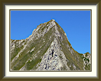
An easy walk led up to the Cabane de Bounavau, where there were the first good views of the Vanil Noir. At this point, blue Wanderweg signposts began to appear, indicating that the Vanil Noir and some of its neighbours were to be taken seriously1. The path continued easily to the Col de Bounavaletta2 on its way to the Motélon Valley; right at the Col, the track for the Vanil Noir turned steeply up much rougher ground. At times slightly exposed, it negotiated various easy rock steps before arriving on the northern ridge of the peak, where there were the first new views, including the Dent de Folliéran to the northeast. Of more interest, however, was the prospect in the other direction of the route to the summit in the distance. There wouldn't be a lot of level ground on the way.
Sure enough, there was a fair amount of skipping and balancing over typical karst terrain, reminiscent of the Schrattenflue, but generally steeper. Care was needed over a long stretch where it would be all too easy to twist an ankle. Some of the steepest parts offered an opportunity for harder, but actually less stressful, scrambling. More rough and very tilted ground led to the Pas de la Borière, the crux of the walk. This narrow saddle, precipitous downwards as much as upwards, needs to be crossed with a single awkward step at the bottom. The cable visible in the photo certainly helps. After that, a simple path through grass led to the summit.
A stout metal cross, not well oriented for photography, adorns the summit of the Vanil Noir. Being taller than anything else within ten kilometres, it is naturally a great viewpoint. To the northeast, Switzerland's busy Mittelland extends past the town of Bulle to the Jura Mountains. On the other side lies the valley bowl called the Gros Mont, the starting point for ascents of the Dent de Brenleire and the Dent de Savigny.
I had forgotten why, against normal practice, I had traversed the mountain back in 2005. Now I knew... I felt little urge to cross all that horrible karst again. Continuing down the SW ridge to the Plan des Eaux involved a lot less of it, but presented its own challenges. Off the steepest bit, there were one or two fairly tame ibex in no particular hurry to get out of the way and on the saddle itself, there was something of a rarity in the Alps, a misspelt Wanderweg signpost.
The journey from the Plan down to the Cabane was an unexceptional slog over a stony wilderness, but below the hut I thought I had spotted a small snake on the track; in fact it was a slow worm, a type of legless lizard which is fairly common, though I couldn't remember having seen one before.

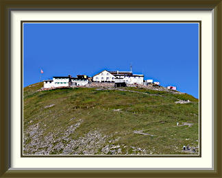
The Faulhorn is a mountain in the Bernese Alps overlooking Lake Brienz. The tourist facilities on its summit are of ancient lineage; the hotel and restaurant were built in 1830. Situated in the middle of the walking Eldorado between Interlaken and Grindelwald, it can be approached from all four points of the compass. There are no mechanical aids to reach the summit, though the lift to First above Grindelwald turns a long walk into a short one. The numerous views include the high peaks of the Bernese Oberland as well as the town of Brienz more than two kilometres below.
 The cold snap had happened as forecast after the last walk.
Just two or three much cooler days and a couple of bouts of
overnight rain meant that snow had fallen to below
2,000 metres and was holding out on north-facing slopes.
Fortunately (and again entirely in character for the middle of September),
the weather then reverted to increasingly warm and dry conditions. A week
later, the fresh snow was already in retreat, and it would be possible to
get quite high on sunnier slopes with no problems.
The cold snap had happened as forecast after the last walk.
Just two or three much cooler days and a couple of bouts of
overnight rain meant that snow had fallen to below
2,000 metres and was holding out on north-facing slopes.
Fortunately (and again entirely in character for the middle of September),
the weather then reverted to increasingly warm and dry conditions. A week
later, the fresh snow was already in retreat, and it would be possible to
get quite high on sunnier slopes with no problems.
But which sunnier slopes exactly? Casting around for the right ones, I hit upon the Faulhorn; two days earlier, it had looked like this, but the snow was going fast. Though it was in the middle of an area where I had done nearly everything else recently, I had not been to its summit since 2005. Starting from the Burglauenen station on the rail line to Grindelwald, it would be an ascent of nearly 1,800 metres, longer than any I had done this year. However, I knew from experience that the paths in this area lent themselves to gaining height quickly. That was enough.
After a reasonably early start, I was able to park near the tiny station and set out in clear, cool conditions around half past seven. There was the usual excellent signposting to guide me, and I was soon making good progress up the cattle pastures on the northern side of the Lütschental. I had to shoo quite a few cows out of my way, easy enough in a wide meadow, but trickier on a single-file path across a steep slope. There were already some fine views towards the Schilthorn area, but the stark morning light made for shadows so dark that photography was unrewarding. It was only at the Männdlenen Hut that sunnier ground arrived. I remembered being surprised to encounter this hut when I crossed the range in 2005; it has only existed in its current form since 2002.
Here at last, the summit of the Faulhorn was visible, now not much higher, but beyond quite a long ridge which would have to be traversed to reach it. Once on top of this ridge, the walking was easy and the views were uninterrupted. As I had expected, the snow was gone from the southern side of the Faulhorn's summit pyramid, and it was the work of a few minutes to reach the top. The summit is a great place to see the high Oberland peaks. While the dark bulk of the Reeti partially hides the Schreckhorn, the view to Eiger, Mönch and Jungfrau is untrammelled. A glance in the other direction towards the the nearby Schwarzhorn (dealt with here) showed that I had indeed gone as high as I could without encountering snow. It wasn't necessary to look up for great views; half hidden by nearer slopes, Brienz and its lake lay more than two kilometres below. And, right at my feet, where countless visitors mill, was a small patch of Edelweiss. A surprise, as this flower is more usually found on less frequented mountain slopes.
Like the last one, this walk was going to be a traverse, descending to Grindelwald via First. The wide path at the foot of the summit pyramid offers the best views of the Faulhorn's summit buildings. Constituting a "Berghotel" rather than a hut, they are some of the oldest of their type in the Alps, having been built in the early 1830s. Soon I had reached the Bachalpsee with its setting which has graced a thousand Swiss calendars. A little busy around the lake, the path was positively crowded as I neared First and its cable car from the valley. There was another surprise there... the cliff which had once been full of choughs now had a tourist gimmick stretched across it which probably wasn't a great development from the point of view of the choughs.
The rest of the walk was a somewhat tedious thousand-metre descent through a maze of paths to get to Grindelwald and catch the train back to my car.
Mont Buet is a mountain in the Chablais Alps in the département of Haute-Savoie in France. While commonly ascended within France from the Chamonix Valley or from Salvagny near Samoëns, it can be reached from the Emosson Reservoir in Switzerland by a somewhat long walk traversing the Cheval Blanc peak (q.v.). It lies some three kilometres from Swiss territory and commands a splendid view of the whole Mont Blanc massif.
 The standard cold snap at the start of September had ended, but
had been followed by unusually warm weather. Temperatures in the lower-lying
cities were around 28°. Up to 3,000 metres at least, the remnants of the
recent snow would be fighting a last-ditch battle in the most sheltered and
sunless spots. I had better use what were surely the last really warm days of
the year.
The standard cold snap at the start of September had ended, but
had been followed by unusually warm weather. Temperatures in the lower-lying
cities were around 28°. Up to 3,000 metres at least, the remnants of the
recent snow would be fighting a last-ditch battle in the most sheltered and
sunless spots. I had better use what were surely the last really warm days of
the year.
There were still plenty of peaks in the Valais if I didn't mind the long drive, but I wanted something... different. One way of being different would be if the peak were not in Switzerland at all. When I had done the Cheval Blanc on the French border in 2014, I had seen a higher, broad-backed mountain several kilometres into France along what looked like an easily walkable ridge. Mont Buet (also appearing in the literature as "Le Buet" or, absurdly, "Mont Blanc des Dames") looked promising. Discounting routes from the Chamonix Valley, none particularly attractive and all involving big ascents, the only appealing way up it would be to do the full Cheval Blanc walk from the Swiss side (...enough to qualify it as "a walk in the Swiss Alps"!), and set out along that ridge. It would be strenuous, and the drive to the starting point would be more than two hours; an early start would be needed.
I was duly on the road by five and at the Emosson Dam car park by a quarter past seven. The upper car park was closed for some sort of bike race; indeed the race was going to close the whole road up, but fortunately only in the middle of the day. Another surprise was that the raised walkway above the access road to the upper dam was gone. Work on the upper dam had been completed, and walkers could safely use the road again. There were no further novelties on the familiar route to the Cheval Blanc.
On top, there was a good view of the upper reservoir, empty when I last saw it in 2014. With the dam rebuilt to raise its height, three years of refilling of the reservoir had only just finished. There was also a clear view along the ridge to Mont Buet's massive east face. The route would stay below and to the east of that ridge all the way to the foot of a steep ascent onto the summit ridge of Mont Buet itself. After a brief rest, I set off, leaving the last waymarks behind and descending a little before crossing a strange area covered with stones of two distinct colours. Further along, the route skirted the modest peak on the ridge called the Pointe du Genévrier and here, with its absence of markings, it became quite hard to follow. At times, I needed to look twice to be sure I was still on it.
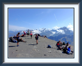
The little track finally arrived at a saddle identified only as Pt. 2808. Here the way onto Mont Buet loomed above. With high-quality steel cables anchored to the rock all the way, it was less dangerous than it looked, but it was still no place to be taking photographs. At its upper end, a big cairn marked the start of the easy path along Mont Buet's summit ridge. It was still a considerable walk, twenty minutes or so, before I was at the highest point. No mere cairn here, but a raised platform with a panorama table. Not much chance of photographing it unattended! Though there had been a few people coming and going along the way from the Cheval Blanc, nothing prepared me for the crowd on Mont Buet. There must have been more than fifty people on the whaleback slopes around the highest point. They picnicked, sunbathed, scanned the Mont Blanc Range, pored over their Fitbits... creating an almost parklike ambiance, despite the altitude. All but a handful of them would have made the ascent from the French side, typically from around Le Buet on the Chamonix - Martigny road, a bigger ascent over a shorter distance, but no harder than T3.
Tearing my gaze away from the crowds for a moment, I could look down Mont Buet's somber, crumbling east face, so impressive from the Cheval Blanc. Being higher than anything else nearby, the mountain was a great viewpoint in all directions, but haze hid many of the peaks to the east. To the south, across the Aiguilles Rouges, Mont Blanc was looking better. I could afford just three quarters of an hour to munch my sandwiches and take in the atmosphere before it was time to set out on the long journey back. By the time I got there, all was quiet around the summit cairn on the Cheval Blanc. Further down, near the dinosaur footprints high above the upper reservoir, I came across a striking remnant chunk of folded strata I hadn't noticed in 2014. The shadows were growing longer as I descended into the Veudale Gorge towards the lower dam and my still-distant car.
It was just the middle of the month, but with a planned trip to Spain and other social duties coming up, it was time for the curtain to come down on the 2019 walking season.