


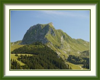
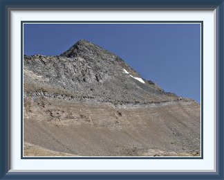
The Gantrisch is a mountain at the edge of the north-western Bernese Alps, overlooking the Aare River Valley and the flatter country to the north around Bern. It is a popular ascent from the Gurnigel Pass.
 Once again, we had arrived rather late in the season, so I needed to get a move on.
The late arrival mattered less than it might have, because local reports were that
it had not been a good summer so far. After a very warm April (of use neither to
skier nor walker), the weather had been changeable and cool.
I dismissed the jetlag as usual and set off for the starter walk up
the Gantrisch
the day after we had landed from NZ.
Once again, we had arrived rather late in the season, so I needed to get a move on.
The late arrival mattered less than it might have, because local reports were that
it had not been a good summer so far. After a very warm April (of use neither to
skier nor walker), the weather had been changeable and cool.
I dismissed the jetlag as usual and set off for the starter walk up
the Gantrisch
the day after we had landed from NZ.
The weather was as advertised, with a northwest flow piling clouds against the Prealps, and as I parked my car in the usual place the tops were hidden and a cold breeze blew. In spite of the poor conditions, the track wasn't completely empty. Along with a trio of extremely slow tourists there was a fun expedition of adults and children using goats as pack animals, not an idea I had seen in this area before. The little Morgetepass kiosk wasn't open for business; the absence of a flag on the pole is the clue to those starting out below that BYO is the order of the day. I had the summit to myself and my timing was fortunate, as the clouds lifted off the local summits while I was there. There were no distant views, but the gaps in the cloud allowed the sun to highlight parts of the landscape below, including the hill above the little Gantrischseeli, while passing cloud emphasised the forbidding contours of the Nünenen next door. Heading back down, I took a steep short cut off the normal path cutting out the trek over the Schibespitz and the Morgetepass just as the rain began. The journey down to retake the main trail became a slithery mud bath, demanding extra concentration to stay upright.

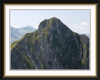
The Ochsen is a mountain in the Bernese Prealps near Schwefelbergbad on the road to the Gurnigel Pass. Though the highest point of the Gantrisch Chain, it is much less frequented than the Gantrisch itself.
 An area of fine weather had moved over Switzerland, so this next outing was just
two days after the first. Something new but modest was required, to match still
modest levels of fitness, so the searchlight fell on a peak close by the Gantrisch,
the Ochsen.
Just two peaks to the west in the same chain and of very similar size,
it could hardly have been more different in the number of visits; I could find
records of just two previous ascents, both in the nineties.
An area of fine weather had moved over Switzerland, so this next outing was just
two days after the first. Something new but modest was required, to match still
modest levels of fitness, so the searchlight fell on a peak close by the Gantrisch,
the Ochsen.
Just two peaks to the west in the same chain and of very similar size,
it could hardly have been more different in the number of visits; I could find
records of just two previous ascents, both in the nineties.
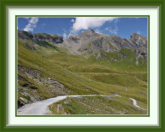
Like the Gantrisch, there is a comfortable roadside car park right at the start of the track, which passes through the grounds of the Schwefelbergbad Hotel complex before heading straight up the mostly grassy and slightly monotonous Louisgrat. This ridge affords fine views of the Ochsen summit before it ends on the crest of the range, well to the west of the peak. The traverse to the saddle below the summit would provide a pleasant break in exertions if it were not trampled into an obstacle course and fouled by the cattle grazing on the alp. The saddle has a fine view to the final peak and the track is clearly visible as it heads up to the summit rocks.
With the weather at its best, the summit had fine panoramas over the Niesen chain to the giants of the Bernese Oberland. To the north, the view extended to Bern and the Jura mountains beyond Solothurn, and the Schwefelbergbad Hotel at the start of the track was visible eight hundred metres below. Descent was by the same route as the ascent. Halfway down the Louisgrat is a small ski lift which with recent weather patterns must struggle to pay its way. Back at the hotel, ordering a coffee or a beer is enough to forestall a (very small) fine levied for use of the roadside car park belonging to them.
The Schopfenspitz is a mountain at the head of the valley bowl called the Breccaschlund in the Fribourg Prealps. It lies just south of the popular tourist resort of Schwarzsee and commands views to the south over the road to the Jaunpass.
 The Schwarzsee near Fribourg was an area where I had done very little over
the years. It lies in the rugged Prealps and is surrounded to the south
and east by peaks exceeding 2000 M. At the southern end of the lake lies
the high river valley called the Breccaschlund, and the tallest of the
peaks enclosing this slightly remote area is the Schopfenspitz. With a
short rainy spell drawing to an end, and cloud still wreathing the
higher peaks, this looked like a promising target.
The Schwarzsee near Fribourg was an area where I had done very little over
the years. It lies in the rugged Prealps and is surrounded to the south
and east by peaks exceeding 2000 M. At the southern end of the lake lies
the high river valley called the Breccaschlund, and the tallest of the
peaks enclosing this slightly remote area is the Schopfenspitz. With a
short rainy spell drawing to an end, and cloud still wreathing the
higher peaks, this looked like a promising target.
The walk begins from the southern shore of the lake, where there is a car park at the end of the public road. A jeep track heads around the forested slopes of Les Recardets ridge into the Breccaschlund. This mixture of French and German naming is characteristic of an area right on the linguistic border between French and German Switzerland. The hordes of tourists, bikers and campers were soon left behind, and a short cut up through the forest was memorable for the delicious smell of a thicket of raspberry bushes. Soon the track rejoined the jeep roads for the journey up to the head of the valley. Here, there is a choice of paths either directly towards the peak, or up to a saddle with a traverse to the summit. As the choice is not signposted at the Combi Chalet, I ended up on the somewhat poorly marked track to the saddle; to find the direct track, you need to stay low until you reach the scree slope on the left a little beyond the chalet. After the saddle, the rest of the way to the top is a pleasant trek up a grassy ridge towards the tiny figures of walkers already on top and the inevitable cross, this peak being in a Catholic canton. From the narrow summit, there is a fine view of Jaun Village below. Of course, from the summit it was easy to see where the direct descent to Combi Chalet lay, so I was spared the journey back to the saddle.
After Combi Chalet, the rest of the journey was a pleasant trek in the afternoon sunshine through a mixture of stony pine forest and alpine farmland.
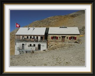
The Wildstrubel Hut belongs jointly to the Kaiseregg and Wildhorn sections of the Swiss Alpine Club. The original 1927 building was massively extended in the early 2000s. It lies near the western end of the Plaine Morte Glacier, which can be crossed to reach the Wildstrubel summit. Ask at the hut about a safe route across the ice!
 A spell of very warm weather was beginning, fairly typical for
the second half of August in Switzerland, so targets higher up
were in order, like the Wildstrubel Hut, not five hundred
metres lower than the eponymous mountain it serves.
The starting point for the track to the hut is at
If figenalp at the end of an alternating
one-way road, so the day began with a tense drive through the
Simmental to the beginning of the road above Lenk, hoping not to
miss a slot and have to wait three quarters of an hour for the next one.
A spell of very warm weather was beginning, fairly typical for
the second half of August in Switzerland, so targets higher up
were in order, like the Wildstrubel Hut, not five hundred
metres lower than the eponymous mountain it serves.
The starting point for the track to the hut is at
If figenalp at the end of an alternating
one-way road, so the day began with a tense drive through the
Simmental to the beginning of the road above Lenk, hoping not to
miss a slot and have to wait three quarters of an hour for the next one.
The track begins by traversing a vast sunless cliff before a series of hairpin bends up grass slopes high above the If figenalp settlement and car park. An hour or so later, the landscape is stonier as you pass the little Rawil Lake and its Wildhorn backdrop. Behind the lake, the track begins to ascend steep, rubble-strewn cliffs, and the hut comes into view. Odd, I didn't remember anything like that... and indeed, as I stood in front of the Wildstrubel Hut at last, it seemed only half familiar. This is what it looked like in 1977. One could argue the architectural merits of the extension, but unfortunately the ridge above the hut is the site of an extensive military installation, destroying the wilderness feel of a once remote area and fouling every second photograph with the wires of the cable car that serves it, making details of the hut's appearance seem suddenly less important. I was going to fulminate on the desecration of the landscape since my last visit until I noticed that the shadows of the same wires are visible in the 1977 photograph. Clearly the military have been there for a long time.
The cairn fairy had been active at this hut too.
Far better than hanging around the hut is to continue the short distance to the crest of the Bernese Alpine range in this area, and enjoy the splendid panorama from the gentle summit of what appears on the LK as Pt. 28851. Well off to the east, the summits of the Wildstrubel overlook the Plaine Morte Glacier. This unusual bowl of ice contains nearly a cubic Km. of it, but is now forecast to be gone completely by 2100 if climate trends don't change. To the south, there is a panoramic view of the Valaisian Alps and the Huiton wilderness below.
The journey down from the hut in the afternoon light has fine rocky scenery before the final cliffs with their view down to the If figenalp roadhead and distant Lenk.
The Wasenhorn is a mountain in the Lepontine Alps on the Swiss-Italian border to the east of the Simplon Pass, from which it is usually walked. In good weather, thre are splendid views of the high Valaisian peaks and Brig, more than 2500 metres below.
 The spell of very warm weather was nearing its peak, with temperatures
on the plains well over thirty degrees, so altitude was even more at
a premium. At 2000 M. it was likely to be about 23°C after midday,
so I needed to go higher than that. Nearest to my home base, there
were various candidate peaks in the Bernese Oberland,
but in every case they involved ascents
of around two thousand metres from the lowlands and a sweat-drenched
descent into the afternoon heat, or cheating by
taking a cable car to the middle levels. This was therefore the day
for a longer drive to fresh pastures, in this case using the vital
short cut afforded by the drive-on trains through the Lötschberg
Tunnel to reach the Simplon Pass. Starting from there at 2005 M., the
Wasenhorn looked like enough effort for a decent day.
The spell of very warm weather was nearing its peak, with temperatures
on the plains well over thirty degrees, so altitude was even more at
a premium. At 2000 M. it was likely to be about 23°C after midday,
so I needed to go higher than that. Nearest to my home base, there
were various candidate peaks in the Bernese Oberland,
but in every case they involved ascents
of around two thousand metres from the lowlands and a sweat-drenched
descent into the afternoon heat, or cheating by
taking a cable car to the middle levels. This was therefore the day
for a longer drive to fresh pastures, in this case using the vital
short cut afforded by the drive-on trains through the Lötschberg
Tunnel to reach the Simplon Pass. Starting from there at 2005 M., the
Wasenhorn looked like enough effort for a decent day.
The Lötschberg train was the usual turn-up-and-drive-straight-on experience, and I was parking the car on the pass by ten o'clock. A few minutes above the road, the track runs alongside a channel laid to take water from the glacier-fed streams ahead. These flow from the imaginatively-named Chaltwasser (Cold Water) Glacier on Monte Leone. Most of them have crude bridges, but one or two don't and could be dif ficult to cross without getting water in your boots when in full flow in the afternoon. After a slog up the lateral moraine of a long-gone glacier, the Wasenhorn finally comes into view above the wilderness surrounding the Monte Leone Hut, which is situated at one of the numbered survey points demarcating the border with Italy.
The marked track ends at the hut, and conditions become much tougher, though traces of a path are still visible in the dusty rubble leading up to the south ridge. The upper stretches of this ridge are a jumble of frost-shattered boulders which look as if they might slump into the valley at any moment, and it is a welcome relief to stand at last on the summit, not that is much better held together. The summit is, not surprisingly given its height, a tremendous viewpoint. Towards the sun, the giant Valaisian peaks were lost in the summer haze, but nearby Monte Leone had no such problems. Across the Rhône Valley, two of the great Bernese Oberland glaciers could be glimpsed, the Aletsch on the left and the Fiescher on the right.
Even at this height, humans weren't the only form of life enjoying the view. What looked like a bumblebee on a summit boulder was probably a hoverfly evolved to do just that.
There was more time to enjoy the scenery on the way down, including the delightfully situated but nameless lake below the hut and the protected all-year Simplon Pass road far below.
The Grindelwald Schwarzhorn is a mountain in the Bernese Alps between Grindelwald and Brienz. It is the highest point in the ranges north of Grindelwald, which also include the Faulhorn and the Reeti. It has magnificent views of the Bernese Oberland summits of the Wetterhorn, the Schreckhorn and the Eiger. The walk up it can be shortened by taking the gondola lift to First.
 The spell of very warm weather was still hanging on, but becoming more
thundery by the day. A peak with an option to retreat was needed. The
Schwarzhorn,
the tallest of the forepeaks around Grindelwald sprang to
mind. While the ascent from the end of the motorable road behind the
village was 1700 metres, the descent could be halved and a drenched
trek across the lower slopes avoided by cutting across to the nearby
First lift if thunderstorms threatened.
The spell of very warm weather was still hanging on, but becoming more
thundery by the day. A peak with an option to retreat was needed. The
Schwarzhorn,
the tallest of the forepeaks around Grindelwald sprang to
mind. While the ascent from the end of the motorable road behind the
village was 1700 metres, the descent could be halved and a drenched
trek across the lower slopes avoided by cutting across to the nearby
First lift if thunderstorms threatened.
With the car parked at the Hotel Wetterhorn park, where a modest charge covers the whole day, I set off across the verdant slopes of the upper Grindelwald area. This is relatively tedious; mass tourism means that there are lots of walking paths, but they cater to a larger market by running along the contours and seldom if ever heading straight up the hill. Thus there is a plethora of choices to reach the upper slopes, but none of them are quick, and you run the risk of finding yourself on an asphalt road.
Above the summer hamlet of Oberläger, the tracks become more interesting and direct. As the grass fades, the Schwarzhorn summit comes into view, some five hundred metres of scree and rubble above. There is quite lot of this to overcome, and one short vertical step with a small chain for the nervous, before the narrow summit rocks. On top, the Eiger North Face on the other side of Grindelwald serves as a fine background for tourist photos. With the dark tint of the local rock, much of the summit area resembles a mining slagheap. Though the summit is a viewpoint to rival the Schilthorn, nothing has been constructed here and you can enjoy the magnificent panorama in relative solitude.
The Bürglen is a mountain in the Gantrisch Chain between the Ochsen and the Gantrisch. Its easy ascent can be made as a side trip from the journey up the latter.
 The last hot weather of the year had come to an end,
if not with a whimper, then with much less of a bang than forecast.
A cold front had moved over Switzerland, but
in place of violent evening winds and widespread heavy thunderstorms,
Burgdorf at least had only a period of calm rain and a few lightning flashes
in the small hours, and things were already clearing by the next
morning. Why do meteorologists so often stick their necks out like
this? Don't memories of past cock-ups ever prompt caution?
The last hot weather of the year had come to an end,
if not with a whimper, then with much less of a bang than forecast.
A cold front had moved over Switzerland, but
in place of violent evening winds and widespread heavy thunderstorms,
Burgdorf at least had only a period of calm rain and a few lightning flashes
in the small hours, and things were already clearing by the next
morning. Why do meteorologists so often stick their necks out like
this? Don't memories of past cock-ups ever prompt caution?
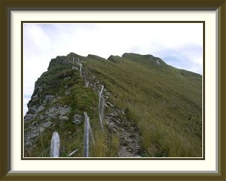
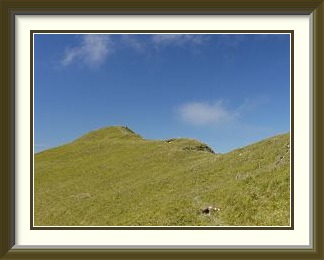
A day later, the consequences for walkers were still there... wonderful visibility in the mountains, but wet snow on higher tracks. Something in the Prealps would do nicely. Between the Gantrisch (done scores of times) and the Ochsen (done thrice) lies the peak called the Bürglen. Seen from the Morgetepass on the way to the Gantrisch, it appears as a harmless grassy slope, so I had always ignored it, but now was the time to tick it off. To make a day of it, I would do the Gantrisch first, then return to the Morgetepass and go up the Bürglen.
Of the Gantrisch, little more needs to be said, except that the locals know their climate well, and crowds of walkers knew that this was the perfect day to climb the mountain. It took patience to get this view of the Bernese Oberland peaks from the summit with only two walkers in the picture.
The surroundings remained grassy even on the approach to the Bürglen summit. Looking back along one's tracks, however, provided a view to the Oberland peaks in fresh snow even better than that from the Gantrisch. The summit was crowded and noisy, and its main point of interest was a new perspective on the trackless northern slopes of the Gantrisch. Seen in profile, they look daunting, but not impossible. Descending at last, you look down on the Morgetepass and the Upper Morgete Alp.