


The Albristhorn is a mountain lying between Lenk and Adelboden in the Bernese Oberland. It is the southernmost summit and the highest point on the long ridge stretching southward from the Niesen near Lake Thun.
 July's terrible weather had continued into August, with less outright flooding,
but with thunderstorms still as likely as sunshine. A wait of a few days
would have been perfectly in order, but the Congenial Swiss Lady was about
to go back to work and was eager to walk if possible.
July's terrible weather had continued into August, with less outright flooding,
but with thunderstorms still as likely as sunshine. A wait of a few days
would have been perfectly in order, but the Congenial Swiss Lady was about
to go back to work and was eager to walk if possible.
So it was that I drove though patches of low mist and generally dull skies to collect her from Bern and continue to Adelboden. Up the little road into the back of the valley behind the town, we found the perfect parking place right at the start of the path to the Albristhorn, the last peak and the highest of the long chain beginning with the Niesen far to the northeast. With the forecast for the day having been unvaryingly mixed during the preceding three, the plan was just to proceed as long as the weather didn't turn against us.
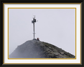
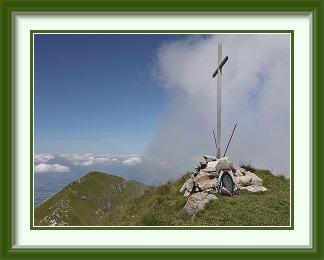
The path headed up steep, wet grass towards our first waypoint at the little Furggi Alp, where I remembered from walks in the late nineties that the farmer kept a few pigs in addition to the usual cattle. The pigs were still there; the CSL explained that they were probably kept to eat scraps that would otherwise have had to be disposed of as garbage. As we gained height, we had a view southwards to the green slopes of the Sillerenbühl, with the stony peaks bounding the western end of the Plaine Morte Glacier on the horizon. Behind the Alp, the path ascended more steep grass to the Furggeli Saddle, but it reached the crest some fifty metres higher than the lowest point, marked by the big cairn in the picture.
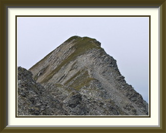
We could still see the Furggi Alp below, and the road to our parking place much further down, but it was clear that cloud was going to be a problem. Nevertheless, there were walkers ahead of us, so we decided to continue up the track towards the mountain. The last grass was soon left behind, and amidst all the boulders, there were some interesting remnants of folded strata. It took only an hour or so to get to the summit of the Albristhorn, where we ate our sandwiches as the mist came and went. Now the question was whether we should descend the same way, or do a traverse of the mountain by taking the much longer south ridge called the Sattligrat? Once again, the sight of walkers on the Sattligrat nearby made up our minds for us, and we walked the next four kilometres between scenery and fog. Along the way, the cairn fairy had been experimenting with a new cairn design, involving a central spike holding the whole structure together. The long descending ridge mixed stony and grassy stretches until it became entirely green below the last peak on the ridge, the Tierberg. A short distance further on, we could finally leave the ridge at the Lavey chairlift, where we had a view back to the now distant Furggi Alp and the saddle above it before the long journey down alpine meadows past the Sillerenbühl to the valley and our car park. The weather had failed to deter us, and had in the end not even spoiled the experience, apart from interfering a little with photography.

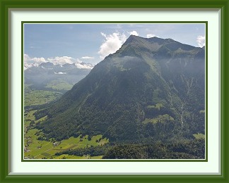
The Niesen is a prominent peak on the shores of Lake Thun in the canton of Bern. It forms the northern end of a ridge that stretches some twenty kilometres from the Albristhorn near Adelboden. Its pyramidal shape makes it a popular calendar subject and its summit is accessible by funicular.
 A promised stable high had failed to materialise, and the weather continued
mixed; there was a lot less rain, but conditions were humid and cloudy. At
least it wasn't cold.
A promised stable high had failed to materialise, and the weather continued
mixed; there was a lot less rain, but conditions were humid and cloudy. At
least it wasn't cold.
It probably wasn't a great strategy to wait for the weather to improve, and I needed the exercise. A "safe" peak with a decent elevation would fit the bill. The Niesen sprang to mind, unsurprisingly, since I passed it so often on the way to other walks. There are about half a dozen main tracks up this prominent peak, all moderately long, but barely exceeding T2 because they are so well trodden. Three of them I had done (like this one), and I felt no particular urge to complete the list. On the other hand, I had seen at least one walker arrive at the summit from the northwest, where none of the main tracks ended. Sure enough, the SAC guide1 included an unmarked track branching off the most direct common route from Wimmis to tackle the northwest ridge. It did mention that it was indistinct.
I parked the car by the Burgflue, a forested hill on a back road out of Wimmis, and headed up a motor track for a while before finding the direct path from Wimmis to the Niesen via Stufenstein. The track was broad, but unusually wet underfoot for the time of year. Some 750 metres up, at a little alp called Im Vorderen Ahorni, the ridge was visible above the forest, but the peak was still a long way away. Just how wet the season had been became clear a little further on, where the track had been cut by a substantial landslip; luckily the mud had settled enough to be walkable. Not far above this, a hairpin bend with a bench served as a waypoint; a hundred metres beyond, the unmarked track up the northwest ridge was supposed to begin. I counted my steps to avoid missing the point where a brief interruption in the ground cover indicated the start of the track. It really was indistinct; there were just one or two splashes of red paint as it worked its way through woodland up to the ridge proper, much of the time barely visible under tall, ungrazed grass.
There was quite a tiring half-hour or so where the dripping undergrowth uttered clouds of mosquitoes at every step, forcing me to keep moving to stop them from settling. In the event, I exited onto the zone of open grass on the ridge puffed but unbitten. From there, it was a straightforward ascent up the increasingly stony ridge to the summit. Near the top, I passed some strange military installations I had often wondered about as I drove past on the lakeside motorway below.
The summit area is heavily developed, and the funicular railway up the eastern side of the peak brings large numbers of visitors. Cloud came and went over the heads of the crowd, and there wasn't much of a view. This crowd contained a welcome surprise, however, a colleague from my time working in China not seen in fifteen years, and his Swiss counterpart. What would have been a dull summit experience turned into an hour and a half of engrossing conversation about the events of the intervening years. I had plenty of food for thought as I headed down the Stufenstein track to Im Vorderen Ahorni and the car.
La Pare (or La Para or La Tornette...) is a mountain north of Les Diablerets in the canton of Valais, from which it is fairly easily reached. It commands fine views of the Diablerets Massif to the south.
 The weather continued terrible; the days since the last walk had either
ended in thunderstorms or had had substantial rain during the daylight
hours. A single day of partial sunshine was now forecast before the
next band of rain arrived. Even in this case, the outlook was more
uncertain for the centre and east of the country. It would be best to
go as far west as possible, and not too high.
The weather continued terrible; the days since the last walk had either
ended in thunderstorms or had had substantial rain during the daylight
hours. A single day of partial sunshine was now forecast before the
next band of rain arrived. Even in this case, the outlook was more
uncertain for the centre and east of the country. It would be best to
go as far west as possible, and not too high.
The spotlight fell on a peak above the village of Les Diablerets called La Pare, little known in the German-speaking part of the country. It is called La Tornette or La Para on my old LK from about 1977. Perhaps it is little known because the attempt to confuse people by abandoning one name and changing the other was successful? In any case, I drove for about two hours to get to the railway terminus in Les Diablerets, which had parking places endearingly free of meters, and set off up the usual tangle of zigzags through the holiday chalets.
The going was soft, indeed at times sodden, on the tracks through the forests above the village, but they soon gave way to a mixture of alp roads and tracks higher up. The view opened out in the morning sunshine to reveal the peaks along the Rhône Valley beyond the local hills. After its one steep stretch, the path arrived at the little Arpille Alp, attractively situated under a prominent rock stump known as the Cape au Moine and the only really stony part of the walk.
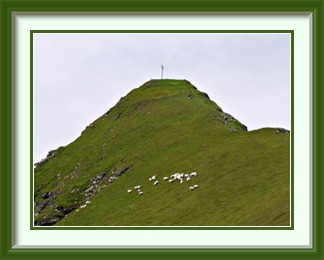
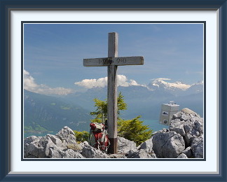
Instead of heading for the saddle at the back of the alp, the path turned west and took a more direct route towards the peak. Despite the height, the rest of the ascent was on grass and the summit even came with a flock of sheep. The immediate area around it had been fenced off, however, so that there was no fouling for once. This is not a place for solitude; it's a popular walk with people from the French side, and there were eight other walkers on top when I arrived. It has good views in most directions, notably towards Les Diablerets village and its eponymous peak.
The Mettelhorn is a mountain in the Pennine Alps near Zermatt, from which it can be walked. A snowfield has to be crossed to reach the summit; ask in Zermatt if crampons are necessary. The nearby summit of the Platthorn is a perfectly good alternative if the snow is not in condition. Views are peerless - nearly all of the Pennine 4000ers can be seen from this one point.
 In the middle of the month we were in Zermatt for a few days for a little
family gathering. The hotel rooms had been booked months in advance, so
there was no chance to second-guess the weather. In the event, it was cold
and rainy on the northern side of the Alps as we arrived, with snow falling as
low as 2000 metres. The effect on the high valleys south of the Rhône
Valley was somewhat different, as it often is. Thick cloud mantled the
spectacularly glaciated peaks like the Matterhorn, but the resort itself
and the lower slopes were bathed in sunshine most of the time. It was
unseasonably cold, however.
In the middle of the month we were in Zermatt for a few days for a little
family gathering. The hotel rooms had been booked months in advance, so
there was no chance to second-guess the weather. In the event, it was cold
and rainy on the northern side of the Alps as we arrived, with snow falling as
low as 2000 metres. The effect on the high valleys south of the Rhône
Valley was somewhat different, as it often is. Thick cloud mantled the
spectacularly glaciated peaks like the Matterhorn, but the resort itself
and the lower slopes were bathed in sunshine most of the time. It was
unseasonably cold, however.
At the top of the (overpriced) Gornergrat cog railway, it was well below zero in the early afternoon. Luckily, the sun was making the difference between pleasant enough conditions and real cold, and the thick cumulus was scattered enough that one or other of the ice giants was always visible. I had my eye on the intermediate peaks, including the Mettelhorn. The previous evening's drizzle in Zermatt had left them with a thin covering of fresh snow; would it have disappeared by the morrow? In the event, I was able to watch the thin grey veil fade completely from the similarly sized Oberrothorn in just a couple of hours, so the outlook for the Mettelhorn was good.
The day dawned fine and, a rare treat, the start of the walk, the big signpost at the railway station, was two hundred paces from my hotel. A quick walk along the main shopping street, a brief ascent through the peripheral chalets, and Zermatt's cosmopolitan world was receding beneath me. The comfortable path entered the gorge of the Triftbach stream, constrained by rock walls at first, but quickly widening enough to offer a glimpse of the splendours ahead. The landscape opened out at the top of the gorge as the path entered the wide, grassy landscape of the high valley called the Triftchumme. On this fairly easy ground the view grew ever more impressive in the morning sunshine, while thin veils of rising cumulus failed to spoil the day.
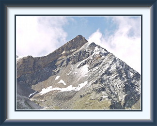
The track climbed steadily into stonier ground and then up a rubble slope with big patches of old snow until it reached the the Furggji saddle, where the Mettelhorn came into view across the Hohlicht Glacier. Crossing this wasn't a problem, as the summer had not been warm enough to expose the bare ice, and I was soon on the final ascent above a pretty frozen pond at the edge of the glacier. There remained only a stretch of steep, shaly ground before I was able to throw my rucksack down on the Mettelhorn's summit rocks and look around.
And what a viewpoint this is! Of the ten tallest mountains in Switzerland, only one, the Grand Combin, is not visible from here. Just to the north is the Weisshorn and even closer is the Zinalrothorn. To the south, beyond Zermatt and the Gornergrat, lie Monte Rosa and the Liskamm, while the route over the glacier was clearly visible below as it skirted the cliffs of the Platthorn in grandiose surroundings. You could spend hours on this summit, but it is composed of slanted boulders that are not very comfortable to sit on!
On the way back down below the Furggji, I encountered some people whose idea of getting around in the Alps was quite different from mine. The weather remained lovely as I stopped for a beer at the Hotel du Trift, really more of a mountain hut, despite its claims of hotelness. The rest of the walk down to Zermatt went without incident, and I was back in my hotel room by late afternoon after a day that would be hard to beat.
The Drunengalm is a mountain near the northern end of the Niesen Chain in the Bernese Alps. It is the highest point on the northern part of the Chain, and is approached by a path from the lower Diemtigtal Road.
 The fickle and unpredictable weather continued. Even the forecasters on
Swiss Television were looking resigned. With the weekend ahead, I looked
at the teletext on Friday morning to see which day would be better for an
outing. The answer was neither; today's day looked like a much better bet
than either of them. Nothing for it then but to gulp a quick breakfast,
throw my stuff into the rucksack and head off. I would try the Drunengalm;
unlike its next-door neighbour in the Niesen chain,
the Fromberghorn,
it has a recognised path all the way to the top and no particular challenge.
The fickle and unpredictable weather continued. Even the forecasters on
Swiss Television were looking resigned. With the weekend ahead, I looked
at the teletext on Friday morning to see which day would be better for an
outing. The answer was neither; today's day looked like a much better bet
than either of them. Nothing for it then but to gulp a quick breakfast,
throw my stuff into the rucksack and head off. I would try the Drunengalm;
unlike its next-door neighbour in the Niesen chain,
the Fromberghorn,
it has a recognised path all the way to the top and no particular challenge.
I drove to the Diemtigtal and parked the car at the bottom of the valley at a spot called Grund. This would give me an ascent of more than a vertical mile, a reasonable day's work. Soon I had climbed out of the riverside forests and the typical Simmental views opened up. The path was at times fairly undistinguished. Above Gsäss, it was sporadically unmarked and invisible up steep meadows; in situations like this, where you can't see the next marker, keeping going in the same direction is the best policy. At Obere Drune, five hundred metres higher, the path was again difficult to follow. In places, what looked like the obvious path ahead turned out to be a dead end, and I had to backtrack to find the mystery turn. At the start of the final ascent to the crest, the track was barely discernible in the summer grass. In no time, I was looking across at the Fromberghorn's steep northwest face, and a little later the path arrived at the crest of the range and the Kander Valley burst into view on the other side.
The true summit of the Drunengalm lay a short distance along the ridge, only thirteen metres higher. Just like so many other peaks, it had the regulation furniture, though not of particularly durable quality. It was high enough to see the Eastern Simmental laid out like a map below. Indeed, as the highest point on the first ten kilometres of the Niesen chain, it had panoramic views in every direction, though only about half of them were visible this time due to rising cloud.
The Niwen (also “Einigs Alichji”) is a mountain to the west of Goppenstein in the lower Lötschental in the Bernese Alps. It can be walked directly from Goppenstein railway station, and has good views into the upper Lötschental.
 The last walk was three days ago; another day or two's rest would have been
welcome, but the weather continued along its familiar track. Just as with
the last walk, the forecast for the present day was doubtful, but the next
two looked worse. It was best to take the opportunity.
The last walk was three days ago; another day or two's rest would have been
welcome, but the weather continued along its familiar track. Just as with
the last walk, the forecast for the present day was doubtful, but the next
two looked worse. It was best to take the opportunity.
As ever when poor weather was approaching, I chose to go a little further into the Alps, gaining a few extra hours before any rain might arrive. In this case, I needed only to go to Goppenstein, at the southern portal of the Lötschberg tunnel. With a path up the Niwen starting directly from the station, I could park the car at the northern portal in Kandersteg and take the ordinary passenger train for once.
The path ascended the side of the V-shaped valley of the Lonza River in mixed rough grass and woodland, leaving Goppenstein's car train complex quickly behind. It was a full seven hundred metres of steep and frequent hairpins before it emerged suddenly onto a gravel road not far below the mountain hamlet of Faldumalp. This would not be a path to pick as the first of a walking season, unless you want a bad case of what the Japanese call "laughing knees".
The road near the hamlet had a fine view of the Lötschen Valley under a somewhat leaden sky. At a bend in the road, Faldumalp's little Mary of the Snows Chapel turns its back on the panorama. It reminded me strongly of a medieval Norwegian stave church, though it dates only from 1923. The two wreaths by its front door gave it an owl-like appearance from a distance.
The grass ended above Faldumalp and was replaced by a slope of boulders and a kind of heath. When the boulders were covered with lichen and moss, this made for some colourful compositions. It was on this stretch that I came across a pine sapling whose trunk executed a perfect loop on its way upwards. What on earth could cause it to do that? The path finally reached a summit, not yet the Niwen, where there was quite a bit of military construction. Walls and embankments were scattered over the mountaintop in a disjointed fashion, and it was hard to see what they were for; indeed they looked as if they had been abandoned long ago. Then I was walking along a high ridge and skirting another nameless top, and there was a fine view of the Faldumrothorn, a genuinely reddish Rothorn for once and a target for another day. At last I stepped onto the true summit of the Niwen, with its cross and view along the ridge I had just traversed. The cross was quite new and the pieces of the old one were still lying around at its foot. The Niwen has great views of the Bernese and Valaisian Alps, but that leaden sky hid all the tops, and the best views were downwards to places like the little hamlet of Galm in the upper Bachalp Valley to the west. By now, a few flakes of snow as fine as dust were falling. I munched my sandwiches and got out of there before my fingers froze.
The Sonnighorn is one of the tops of the precipitous Simmenfluh ridge which guards the entrance to the Simmental at Wimmis near Lake Thun. The route up largely bare and steep rock is secured for much of its length by a steel cable. Descent is possible via a woodland path down the back of the ridge.
 After more rain, a single really sunny day was forecast. Not a chance to be
missed in a summer like this one! However, I had acquired a Tageskarte
(day card) for Swiss Railways for the morrow, and I intended to get the
maximum value out of it. Thus I couldn't make myself too tired. Most of
the smaller peaks in the vicinity I had done too many times already, and
they were anyway trivial affairs. There was one ascent I had never thought
of trying, though.
The Simmenfluh is the
scantily forested cliff which guards the entrance to the Simmental.
Of its several tops, the Sonnighorn confronted the plains best. Though short,
its ascent via the cliffs towering over the valley road would not be trivial.
After more rain, a single really sunny day was forecast. Not a chance to be
missed in a summer like this one! However, I had acquired a Tageskarte
(day card) for Swiss Railways for the morrow, and I intended to get the
maximum value out of it. Thus I couldn't make myself too tired. Most of
the smaller peaks in the vicinity I had done too many times already, and
they were anyway trivial affairs. There was one ascent I had never thought
of trying, though.
The Simmenfluh is the
scantily forested cliff which guards the entrance to the Simmental.
Of its several tops, the Sonnighorn confronted the plains best. Though short,
its ascent via the cliffs towering over the valley road would not be trivial.
From the road into the Simmental, the route to the Sonnighorn looms interestingly overhead, with the notch of the Grippeli saddle clearly visible to the left of the peak itself. There are parking places just south of the village of Brodhüsi, right at the start of the approach track through the forest. It was a matter of a few minutes to reach the beginning of the route, from here on excellently marked in white-blue-white paint, with steel cables providing security on the many exposed stretches. For much of the time, my free hand count was too low to allow the taking of photographs, but now and then, a respite in the steepness let me get my camera out. At one point, the track looked vertiginously down to the highway entering the Simmenfluh Tunnel below. Slowly the angle of the slope relented, and the now more conventional path reached the Grippeli saddle, a tight little jumble of stones and pine trees. It only remained then to traverse the vertical west face of the peak before the final short and steep ascent to the summit.
Half a dozen hikers had arrived before me, so that I had to wait nearly an hour to get a clear picture of the narrow, bouldery summit area, with the obligatory cross and a summit book holder. (Despite appearances, the latter has not been Photoshopped in; it is bolted to the only suitable boulder around.) At this modest elevation, the tops nearby seemed to have a tree in every crevice. The Sonnighorn is a good illustration of the fact that height is not necessary for great views, such as that along Lake Thun toward the Oberland peaks. Descending via the same route would have been tedious, but fortunately there was a more conventional woodland path down the other side of the Grippeli saddle, and the journey around the base of the mountain didn't take long.